world.wikisort.org - United_Kingdom
Kirkoswald (Scots: Kirkossald)[1] is a village and parish in the Carrick district of Ayrshire, Scotland, 1+3⁄4 miles (3 kilometres) from the coast and four miles (six kilometres) southwest of Maybole. It takes its name from its kirk (church), dedicated to Oswald of Northumbria, who is said to have won a battle here in the 7th century. The old church, which was built in 1244 and houses the baptismal font of Robert the Bruce, is now a ruin in the grounds of the modern church, which was built in 1777 to a design by Robert Adam. Kirkoswald is also noted for its connection with Robert Burns, whose maternal ancestors, the Brouns, were from the village. Burns also attended school here, and would later base the characters Tam o' Shanter, Kirkton Jean and souter Johnnie on village locals Douglas Graham, Jean Aird and John Davidson, the shoemaker.
Kirkoswald
| |
|---|---|
 The Main Street | |
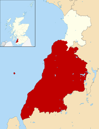
 Kirkoswald Location within South Ayrshire | |
| Population | 194 |
| OS grid reference | NS240075 |
| Council area |
|
| Lieutenancy area |
|
| Country | Scotland |
| Sovereign state | United Kingdom |
| Post town | MAYBOLE |
| Postcode district | KA19 |
| Dialling code | 01655 |
| Police | Scotland |
| Fire | Scottish |
| Ambulance | Scottish |
| UK Parliament |
|
| Scottish Parliament |
|
Kirkoswald village had a population of 194 in 1991. Kirkoswald parish is 23.3 square miles (60 square kilometres) in area, and also contains the coastal village of Maidens. Landmarks include Turnberry Castle, the ancient seat of the Earls of Carrick, Culzean Castle, Thomaston Castle and Crossraguel Abbey.
Rev Robert Hunter Arbuckle was minister of the Free Church from 1860 and 1897.[2]
Gallery
 View of the village from the neighbouring moorland
 The old church
 The War memorial
 The grave of 'Kirkton Jean'
 Grave marker for former slave Scipio Kennedy
 Souter Johnnie's cottage, now owned by the National Trust
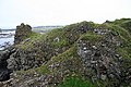 The remains of Turnberry Castle
 View of Maidens village
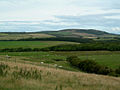 View towards Mochrum Hill


References
- The Online Scots Dictionary
- Ewing, William Annals of the Free Church
- The geographic coordinates are from the Ordnance Survey.
External links
- The Gazetteer for Scotland - Kirkoswald
- Kirkoswald Parish Profile
 Media related to Kirkoswald, South Ayrshire at Wikimedia Commons
Carrick | ||
|---|---|---|
| Settlements |
|  |
| Administration |
| |
| Culture |
| |
| Geography |
| |
| History |
| |
| Sport | ||
| Transport |
| |
South Ayrshire | ||
|---|---|---|
| Towns |  | |
| Villages |
| |
| Other settlements and suburbs |
| |
| Scottish Parliament |
| |
| UK Parliament |
| |
| See Also |
| |
| ||
This South Ayrshire location article is a stub. You can help Wikipedia by expanding it. |
На других языках
[de] Kirkoswald (South Ayrshire)
Kirkoswald ist eine Ortschaft in der schottischen Council Area South Ayrshire beziehungsweise in der traditionellen Grafschaft Ayrshire. Sie liegt rund acht Kilometer nordöstlich von Girvan und 13 Kilometer südwestlich von Ayr unweit der Küste des Firth of Clyde.[1]- [en] Kirkoswald, South Ayrshire
Другой контент может иметь иную лицензию. Перед использованием материалов сайта WikiSort.org внимательно изучите правила лицензирования конкретных элементов наполнения сайта.
WikiSort.org - проект по пересортировке и дополнению контента Википедии