world.wikisort.org - United_Kingdom
Itchingfield is a small village and civil parish in the Horsham district of West Sussex, England. It lies on the Barns Green to Broadbridge Heath road 2.7 miles (4.3 km) southwest of Horsham.
| Itchingfield | |
|---|---|
 Itchingfield Location within West Sussex | |
| Area | 10.91 km2 (4.21 sq mi) [1] |
| Population | 1,477 [1] 2001 Census 1,565 (2011 Census)[2] |
| • Density | 135/km2 (350/sq mi) |
| OS grid reference | TQ131287 |
| • London | 33 miles (53 km) NNE |
| Civil parish |
|
| District |
|
| Shire county |
|
| Region |
|
| Country | England |
| Sovereign state | United Kingdom |
| Post town | HORSHAM |
| Postcode district | RH13 |
| Dialling code | 01403 |
| Police | Sussex |
| Fire | West Sussex |
| Ambulance | South East Coast |
| UK Parliament |
|
| Website | Parish Council |
The main settlement in the parish is Barns Green.
The village's origins may lie with the Romans. This is suggested by the discovery of tiles in the parish.[3]
Gallery
 St. Nicolas c. 1830
 St. Nicolas 2017
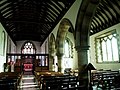 St. Nicolas Interior
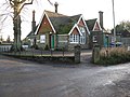 Itchingfield School


References
- "2001 Census: West Sussex – Population by Parish" (PDF). West Sussex County Council. Archived from the original (PDF) on 8 June 2011. Retrieved 12 April 2009.
- "Civil Parish population 2011". Neighbourhood Statistics. Office for National Statistics. Retrieved 1 October 2016.
- "Itchingfield | British History Online". www.british-history.ac.uk. Retrieved 25 February 2020.
External links
![]() Media related to Itchingfield at Wikimedia Commons
Media related to Itchingfield at Wikimedia Commons
This West Sussex location article is a stub. You can help Wikipedia by expanding it. |
Текст в блоке "Читать" взят с сайта "Википедия" и доступен по лицензии Creative Commons Attribution-ShareAlike; в отдельных случаях могут действовать дополнительные условия.
Другой контент может иметь иную лицензию. Перед использованием материалов сайта WikiSort.org внимательно изучите правила лицензирования конкретных элементов наполнения сайта.
Другой контент может иметь иную лицензию. Перед использованием материалов сайта WikiSort.org внимательно изучите правила лицензирования конкретных элементов наполнения сайта.
2019-2026
WikiSort.org - проект по пересортировке и дополнению контента Википедии
WikiSort.org - проект по пересортировке и дополнению контента Википедии