world.wikisort.org - United_Kingdom
Hamstead Marshall (also spelt Hampstead Marshall)[lower-alpha 1] is a village and civil parish in the English county of Berkshire. The village is located within the North Wessex Downs.[1] The population of this civil parish at the 2011 census was 275.[2]
| Hamstead Marshall | |
|---|---|
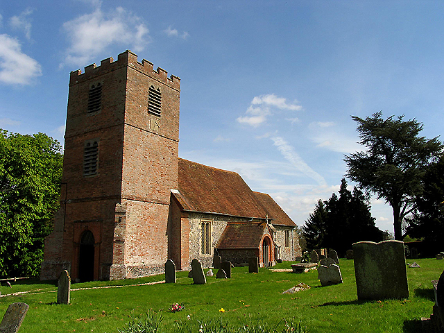 St Mary's Church | |
 Hamstead Marshall Location within Berkshire | |
| Population | 275 (2011 census) |
| Civil parish |
|
| Unitary authority | |
| Shire county |
|
| Region |
|
| Country | England |
| Sovereign state | United Kingdom |
Location and amenities
In the west of West Berkshire (a unitary authority area), south-west of Newbury, on the Berkshire-Hampshire border, the parish covers 7.78 square kilometres (3.00 sq mi), having lost territory in a boundary change of 1991. The village contains scattered settlements such as Ash Tree Corner, Chapel Corner, Holtwood and Irish Hill. There is a 12th-century[3] church (St Mary's),[4] a Dogs Trust canine rescue kennels, the White Hart Inn, Hamstead Marshall's pub for several centuries. There is a village hall (until 1933 it was the village primary school) in which community events are held regularly, and it is also used for private bookings. The Organic Research Centre at Elm Farm closed in 2019 and its land and buildings sold off.
History


Hamstead Marshall has three sites of medieval motte-and-bailey castles, all on private land, with one a possible site of Newbury Castle. All are registered historic monuments. William Marshall, who became Earl of Pembroke, was a loyal knight to four kings: Henry II, Richard I, King John, and Henry III and this is when the Marshall suffix was added to the village. The manor house continued to be owned and used by kings and queens throughout the centuries, until it was sold in 1613.
The village was from 1620 until the 1980s the seat of the Earls of Craven. William Craven built a mansion there, originally intended as a residence for Charles I's sister, Elizabeth of Bohemia, although she died before construction began. It burnt down in 1718. The Cravens later expanded a hunting lodge to live in instead, and this still stands, privately occupied, in the centre of Hamstead Park. Until the mid-twentieth century the Craven family owned most of the village, but successive sales by the estate put almost all the houses into private ownership by 1980, most of them now owner-occupied. About 17 houses are owned by Sovereign Housing Association.
Geography
The village landscape comprises farmland, woodland and parkland. No A or B roads dissect this but Hamstead Marshall has bus services. The river Kennet and the Kennet and Avon Canal pass through the northern edge of the village, and the river Enborne marks the southern boundary. About half the property pre-dates 1900, and 32 buildings or structures such as walls are listed under the national planning law and conservation legislation. The village has four areas designated sites of Special Scientific Interest (SSSI), these are Hamstead Marshall Pit, Irish Hill Copse, Redhill Wood and the River Kennet.[5]
Demography
| Output area | Homes owned outright | Owned with a loan | Socially rented | Privately rented | Other | km2 roads | km2 water | km2 domestic gardens | Usual residents | km2 |
|---|---|---|---|---|---|---|---|---|---|---|
| Civil parish | 45 | 31 | 17 | 15 | 10 | 0.083 | 0.185 | 0.176 | 275 | 7.78 |
Notes
- The spelling of the village's name that is used on road signs and that is accepted by most of the village's organisations is Hamstead Marshall; an alternative, Hampstead Marshall, was preferred from time to time, but is not used by the local authority today, although it is the official name of the civil parish.[citation needed]
References
- "The civil parish comprises 1,900 acres/769 hectares" (PDF). Retrieved 5 March 2017.
- "Civil Parish population 2011". Neighbourhood Statistics. Office for National Statistics. Retrieved 30 November 2016.
- "Heritage Gateway - Results".
- Historic England. "Church of St. Mary (1117223)". National Heritage List for England. Retrieved 19 July 2020.
- "HAMSTEAD HORNET Issue 72" (PDF). Retrieved 5 March 2017.
- Key Statistics: Dwellings; Quick Statistics: Population Density; Physical Environment: Land Use Survey 2005
External links
Другой контент может иметь иную лицензию. Перед использованием материалов сайта WikiSort.org внимательно изучите правила лицензирования конкретных элементов наполнения сайта.
WikiSort.org - проект по пересортировке и дополнению контента Википедии