world.wikisort.org - United_Kingdom
Ewell (/ˈjuːəl/ (![]() listen) YOO-əl, inf. /ˈjuːl/ YOOL) is a suburban area with a village centre in the borough of Epsom and Ewell in Surrey, approximately 12 miles (19 km) south of central London and 1.5 miles (2.4 km) northeast of Epsom.
In the 2011 Census, the settlement had a population of 34,872, a majority of which (73%) is in the ABC1 social class, except the Ruxley Ward that is C2DE.[2]
listen) YOO-əl, inf. /ˈjuːl/ YOOL) is a suburban area with a village centre in the borough of Epsom and Ewell in Surrey, approximately 12 miles (19 km) south of central London and 1.5 miles (2.4 km) northeast of Epsom.
In the 2011 Census, the settlement had a population of 34,872, a majority of which (73%) is in the ABC1 social class, except the Ruxley Ward that is C2DE.[2]
This article needs additional citations for verification. (April 2022) |
| Ewell | |
|---|---|
 Dog Gate to Bourne Hall gardens, Ewell | |
 Saint Mary the Virgin, parish church | |
 Ewell Location within Surrey | |
| Area | 14.09 km2 (5.44 sq mi) |
| Population | 34,872 (2011 census)[1] |
| • Density | 2,475/km2 (6,410/sq mi) |
| OS grid reference | TQ2263 |
| • London | 12.1 mi (19.5 km) |
| District | |
| Shire county | |
| Region | |
| Country | England |
| Sovereign state | United Kingdom |
| Post town | EPSOM |
| Postcode district | KT17 KT19 |
| Dialling code | 020 |
| Police | Surrey |
| Fire | Surrey |
| Ambulance | South East Coast |
| UK Parliament |
|
Ewell was founded as a spring line settlement, where the permeable chalk of the North Downs meets the impermeable London Clay, and the Hogsmill River (a tributary of the River Thames) still rises at a spring close to Bourne Hall in the village centre. Recorded in Domesday Book as Etwelle, the settlement was granted a licence to hold a market in 1618.[3] The opening of railway stations to the east and west of the centre, in 1847 and 1859 respectively, facilitated the creation of extensive residential areas, which are now contiguous with the Greater London suburbs.
History
The name Ewell derives from Old English æwell, which means river source or spring.
Bronze Age remains have been found in Ewell[4][5] and the Romans are likely to have encountered an existing religious site when they first arrived leaving pottery, bones, and a few other remains, which have been taken to the British Museum.[3] Ewell is on a long line of spring line settlements founded along the foot of hills on a geological line between the chalk of the North Downs to the south, and the clay of the London Basin to the north.
The Roman road Stane Street from Chichester deviates from straight slightly at Ewell to pass by the central spring. Its successor, the A24 (London Road) runs from Merton to Ewell along the course of the Roman road, and leaves Ewell also with a by-pass connecting it to Epsom.[n 1]
Ewell was traditionally located within the Copthorne hundred.
Ewell appears in Domesday Book of 1086 as Etwelle. It was held by William the Conqueror. Its assets were: 13½ hides; 2 mills worth 10s, 16 ploughs, 14 acres (5.7 ha) of meadow, woodland and herbage worth 111 hogs. It rendered £25 per year to its feudal system overlords; also £1 from the church in Leatherhead, it was held by Osbert de Ow and was attached to his manor.[6] In the 13th century Ewell's current spelling appears, in the Testa de Nevill.[3]
King Henry VIII established here in 1538 Nonsuch Palace on the borders of Cheam, considered one of his greatest building projects. The estate, now Nonsuch Park, a public park, was one of his favourite hunting grounds, although no trace of the palace remains, having been destroyed during the 17th century. In the same park, is Nonsuch Mansion a Grade II* listed 18th-century house occasionally open to visitors.[7]
In 1618 Henry Lloyd, lord of the manor, was granted licence to hold a market in Ewell.[3] The market died away in the early 19th century.[3]
Samuel Pepys visited Ewell on numerous occasions in the 17th century and the area is mentioned several times between 1663 and 1665 in his diary, in which he spells it Yowell.[8]
The enclosure (privatisation) of its common fields of 707 acres (286 ha) in the east and its infertile land ('waste') of 495 acres (200 ha) was carried out in 1801.[3] In 1811 a National School was established sponsored by Mr. White and Mr. Brumfield. Thomas Calverley built the large architecturally listed home Ewell Castle in 1814 in an imitation castellated style and gave the school financial benefaction, which became available in 1860.[3][9] In 1879 Ewell Court House, latterly a library was built with a grotto that survives.[10]
Ewell was largely developed woth semi detached housing in the 1930s, with a minority of the Ewell area built on after World War 2. In the 1980s, an elderly lifelong resident of Ewell, named Digeance, recalled the pasture land and orchards that stretched north and west right across to Berrylands in the Royal Borough of Kingston upon Thames. This radical transformation is documented in the photography collected in the book Archive Photos – Epsom and Ewell.[11] The suburban residential development across that area is mainly 1930s/40s semi-detached houses, although some Edwardian, Victorian and earlier architecture is still present. The Hogsmill Open Space gives an indication of Ewell's rural prewar history.
Government and politics
The town lies entirely within the parliamentary constituency of Epsom and Ewell, and is currently represented in parliament by Conservative Chris Grayling.
Landmarks
Bourne Hall
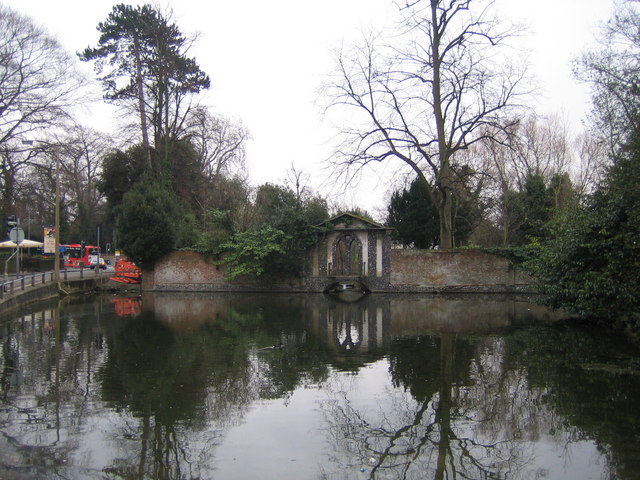

Ewell's largest landmark is Bourne Hall in the centre of the town. It is a modernist circular structure with a central glass dome, built in 1967–70 to a design by A. G. Sheppard Fidler and Associates. The building, which is reminiscent of an immense flying saucer, houses a public library, subterranean theatre, gymnasium, café and local museum, and holds gatherings such as fairs, yoga and karate lessons. It was Grade II listed by English Heritage in 2015 for reasons of architectural interest and also for historic interest as "an ambitious example of the expansion of the library service and the integration of community facilities and disabled access".[12]
Bourne Hall is surrounded by a stream-side public park with a pond at one end and a fountain; these were formerly the grounds of Garbrand Hall, an 18th-century mansion, later used as a school and also called Bourne Hall, which the new building replaced.[12] The garden wall,[13][14] a 19th-century entrance arch to the gardens,[15] the nearby lodge,[16] and an 18th-century bridge inside the gateway[17] were Grade II listed in 1954 and a waterwheel in 1976.[18]
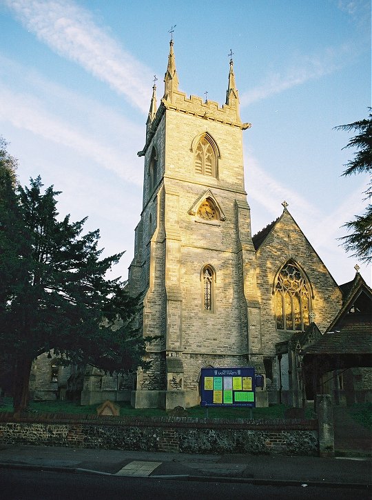
St Mary's Church
Ewell has a C of E Parish Church (Saint Mary the Virgin, Ewell), which was designed by Henry Clutton and consecrated in 1848. The current building stands in a prominent position near the centre of the village on the old London Road. A replacement for an earlier church building on the site, it was built in a form of the Decorated Neo-Gothic style and faced with Swanage stone with Bath Stone mullions and tracery. The church is home to the 1889 'Father' Henry Willis pipe organ. The ruins of the old church's early medieval tower stand alone in parkland and are a Scheduled Ancient Monument.[19]
Other Landmarks
St Paul's Howell Hill is situated in East Ewell and is known locally due to its prominent presence on a roundabout and its contemporary design.
Unlike most parts of its borough, Ewell has telephone numbers using the London 020 area code, alongside Stoneleigh .[n 2] Ewell also has an unusually large telephone exchange, beside The Spring pub, fitted with underground facilities designed to survive a nuclear conflict during the later years of the Cold War. It was transferred in 2000 from the Metropolitan Police, in whose district it had been placed since 1839, to the jurisdiction of Surrey Police.[citation needed]
Economy
Ewell's commercial centre, the High Street is 400 metres long and contains two chain convenience stores, Sainsbury's Local and Nisa (formerly Co-op), in addition to a post office. There are no longer any banks in Ewell. The Green Man public house is located on the High Street, with three other pubs: The Eight Bells, The Wheatsheaf and the Spring located nearby on Kingston Road in the north of the Village.
Neighbourhoods
Ewell Village
The central, historic centre of Ewell containing the High Street, Bourne Hall, Ewell Castle School and immediate surrounding areas.
Ewell Court
Ewell Court is a residential area and ward to the northwest of Ewell Village. In the centre of the area is Ewell Court Park, which contains Ewell Court House and Ewell Court Lake. The volunteer-run Ewell Court Library is inside Ewell Court House. A large portion of The Hogsmill Open Space, a local nature reserve is in this area, from the railway line near Ewell Village to Ruxley Lane. This contains several tributaries of the Hogsmill River, including the confluence with the Horton Stream near Ruxley Lane. Ewell Court is bounded to the northeast by the A240 (Kingston Road).
West Ewell
West Ewell is a large residential area with several local centres. Its main centre is the area around Ewell West railway station, which contains a parade of shops. Its principal roads are Chessington Road and Ruxley Lane. These are both B-roads which contain several parades of shops. A section of the Hogsmill Open Space, including the Bonesgate Stream is in the northern fringes of the area. Ruxley Farm Bridge is in the centre of Ruxley Lane over the Hogsmill River, replacing a ford, Ruxley Splash. West Ewell is served by buses travelling between Epsom and Kingston, as well as Chessington.
West Ewell covers two wards: West Ewell Ward, to the south of Ruxley Lane and Ruxley Ward, to the north.
East Ewell
This is an area of predominantly semi-detached housing dating from the 1930s. This area, to the east of the A24 Ewell Bypass is served by Ewell East railway station. The A232 runs through the suburban area.
A large part of Nonsuch Park, including the old Nonsuch Palace, can be found in East Ewell as can the remains of the derelict Cuddington Church. Warren Farm Local Nature Reserve is also in the East Ewell area.
Ewell Downs
An area of detached housing with several private roads. Located in the south of Ewell, between the centre and Epsom Downs
Surrounding Area
Surrounding areas of Surrey and London | ||||||||||||||||
|---|---|---|---|---|---|---|---|---|---|---|---|---|---|---|---|---|
| ||||||||||||||||
Education

Closest to the town are at senior (secondary) level:
- private day school Ewell Castle School, on Church Street, Ewell Village
- boys (Mixed in Sixth Form) Academy Glyn School, on The Kingsway, just west of Ewell Village[20]
- mixed comprehensive school Blenheim High School, Longmead Road, between West Ewell and Epsom.
- mixed comprehensive school Epsom and Ewell High School on Ruxley Lane, West Ewell
At further education level:
- North East Surrey College of Technology, East Ewell.
For the wider list of all schools in the borough, see borough of Epsom and Ewell.
Parks and Open Spaces
Nonsuch Park
A historic park to the east of Ewell Village, extending into Stoneleigh and Cheam. Former site of 16th Century Nonsuch Palace, current site of Nonsuch Mansion. Home to Nonsuch parkrun, a free weekly 5 kilometre run.
Warren Farm
A local nature reserve in East Ewell owned by the Woodland Trust. Heathland bordered by woodland. Located adjacent to Nonsuch Park and Nonsuch High School.
Hogsmill Open Space
An extensive wildlife corridor, stretching from the Hogsmill source in Ewell Village and extending downstream along the course of the river. This stretches north-west through Ewell Court and West Ewell, extending out to Kingston. Contains three enclosed parks, including Bourne Hall (detailed above in the Landmarks section) and:
Ewell Court Park
An enclosed area incorporating Ewell Court lake and Ewell Court House (with a cafe) . The house was restored after the 2014 fire. The Ewell Court stream flows into the main Hogsmill River on the edge of the park. The Hogmsill acts as a natural park boundary, with fences containing pedestrian gates around the rest of the perimeter.
Poole Road Recreation Ground
An area of green space containing a playground and two grass football pitches.
The Harrier Centre can be found there, containing Ewell Athletics Track, home to Epsom and Ewell Harriers Athletics club. Found in 1890 (the oldest in Surrey), the club have trained at this track since the 1950s. Gauntlett Boxing Club have trained at the Harrier Centre since 2017
Priest Hill Local Nature Reserve
Located in East Ewell, near to the A240.
London Road Recreation Ground
A small park on the northern edge of Ewell Village, containing a large playground and 2.3 hectares of open space
Gibraltar Recreation Ground
A park just west of Ewell Village, next to Ewell West railway station. Contains a bowling green, tennis courts, football pitches and a large playground. Ewell Tennis Club are based next to the Rec.
Sports, recreation and leisure
In Ewell Court, there is a King George's Field in memorial to King George V. Also at the King George's Field, there is Ewell Athletics Track, a UK Athletics Class B track where Epsom and Ewell Harriers , founded in 1890, have trained since the 1950s.[21] The Harrier Centre, a small sports centre also containing a children's soft play area, was built as an addition to the athletics track in 2000. Ewell Tennis Club is also in the Ewell, on the western edge of Ewell Village.[22]
Ewell is also home to Ewell St Mary's Morris Men. Founded in 1979, further to a bequest from the then Vicar, Peter Hogben, for the annual Village Fete – the Team danced into The Morris Ring in the late eighties and now have many unique dances in their repertoire. They dance Cotswold Morris and sport black top hats, red and white baldrics and ribbons.
Ewell is on the London Outer Orbital Path (London Loop) walking route. The path heads through South Cheam into Warren Farm and Nonsuch Park via East Ewell, before crossing into Ewell Village passing Ewell Castle School. It passes through Bourne Hall (at the main source of the Hogsmill River) before heading along the Hogsmill Open Space past the Kingston borough border.
Transport
Ewell is served by two railway stations: Ewell West, which has services towards London Waterloo, Dorking and Guildford, and Ewell East, which has services towards London Victoria, Dorking and Horsham. Both stations are in TfL Fare Zone 6.
Bus services in Ewell include the 293, 406, 418, 467, 470, E5 and E16 providing links to Morden, Kingston Upon Thames and Chessington.
Demography and housing
| Ward | Detached | Semi-detached | Terraced | Flats and apartments | Caravans/temporary/mobile homes/houseboats | Shared between households[1] |
|---|---|---|---|---|---|---|
| Cuddington | 627 | 782 | 435 | 520 | 0 | 2 |
| Ewell | 799 | 482 | 402 | 756 | 0 | 0 |
| Ewell Court | 666 | 1,200 | 127 | 225 | 2 | 0 |
| Nonsuch | 1,733 | 114 | 22 | 60 | 0 | 0 |
| Ruxley | 342 | 690 | 501 | 980 | 12 | 0 |
| West Ewell | 272 | 1,257 | 562 | 307 | 1 | 0 |
| Ward | Population | Households | % Owned outright | % Owned with a loan | hectares[1] |
|---|---|---|---|---|---|
| Cuddington | 5,934 | 2,366 | 39 | 43 | 135 |
| Ewell | 5,532 | 2,439 | 38 | 37 | 155 |
| Ewell Court | 5,417 | 2,220 | 49 | 40 | 146 |
| Nonsuch | 5,438 | 1,929 | 52 | 44 | 610 |
| Ruxley | 6,174 | 2,525 | 29 | 43 | 240 |
| West Ewell | 6,377 | 2,399 | 35 | 46 | 123 |
In art
Pre-Raphaelite artist William Holman Hunt married and produced several artistically and conceptually outstanding works here. The doorway linking St Mary's church yard and the grounds of Glyn House reproduced as the door on which Christ is knocking is arguably his most praised painting, The Light of the World.
Similarly, the background for John Everett Millais' oil on canvas Ophelia was painted at Ewell.
In film, fiction and the media
In August 2005 the borough of Epsom and Ewell was rated the most desirable place to live in the United Kingdom by the British television programme The Best and Worst Place to Live in the UK; the following year's edition figured it in 8th place. The borough's low crime rate, good education results and large number of open spaces were all cited as its particularly attractive features, although being less commercial than the centres of Kingston or London, having a relative 'lack of entertainment facilities'.
Notable residents
Popular singer Petula Clark was born in Ewell in 1932, as well as the broadcaster James Whale, and TV presenter Michaela Strachan. Playwright John Osborne lived in Ewell as a boy.[23] Michael Frayn, author and playwright, lived as a child in Hillside Road, off Queensmead Avenue, East Ewell.
In sport, footballer Ron Harris[n 3] lived in Ewell during the 1970s, cyclist Sean Yates in childhood, Trevor "Tosh" Chamberlain[n 4] lived in the town, and Michael "Venom" Page was a former resident.[24]
See also
- Fitznells Manor
- List of places of worship in Epsom and Ewell
Notes and references
- Notes
- It continues as since Roman times to Leatherhead and Dorking however terminates at the more modern resort of Worthing, 5 miles (8.0 km) east of the small port and cathedral city of Chichester on the coast.
- Anomaly shared with East Molesey and Thames Ditton in Surrey, Chigwell and Loughton in Essex
- Played for Chelsea Football Club
- Played for Fulham Football Club
- References
- Key Statistics; Quick Statistics: Population Density Archived 11 February 2003 at the Wayback Machine United Kingdom Census 2011 Office for National Statistics Retrieved 20 December 2013
- "Location report for Ewell". NS Database. Archived from the original on 26 April 2014. Retrieved 26 April 2014.
- H.E. Malden, ed. (1911). "Parishes: Ewell". A History of the County of Surrey: Volume 3. Institute of Historical Research. Archived from the original on 17 September 2013. Retrieved 5 July 2013.
- Walls, Tom K. "Prehistoric and Roman Settlement in Reigate Road, Ewell". Epsom & Ewell History & Archaeology Society. Archived from the original on 10 February 2015. Retrieved 9 February 2015.
- B Matthews; R Bashford. "Glyn House, Ewell, Surrey: Phase 1 Evaluation Report". British and Irish archaeological bibliography. Oxford Archaeology. Archived from the original on 10 February 2015. Retrieved 9 February 2015.
- Surrey Domesday Book Archived 30 October 2007 at the Wayback Machine
- Nonsuch Park House Historic England. "Details from listed building database (1378198)". National Heritage List for England. Retrieved 5 July 2013.
- "Pepys' Diary Yowell References". Archived from the original on 21 February 2014. Retrieved 4 December 2013.
- Ewell Castle Grade II Historic England. "Details from listed building database (1214625)". National Heritage List for England. Retrieved 5 July 2013.
- Ewell Court House Grade II Historic England. "Details from listed building database (1392614)". National Heritage List for England. Retrieved 5 July 2013.
- Richard Essen, The Archive Photographs Series: Epsom and Ewell (Stroud: The Chalford Press, 1994)
- Historic England. "Details from listed building database (1425772)". National Heritage List for England. Retrieved 1 March 2021.
- Historic England. "Details from listed building database (1288435)". National Heritage List for England. Retrieved 1 March 2021.
- Historic England. "Details from listed building database (1231855)". National Heritage List for England. Retrieved 1 March 2021.
- Historic England. "Details from listed building database (1288436)". National Heritage List for England. Retrieved 1 March 2021.
- Historic England. "Details from listed building database (1214955)". National Heritage List for England. Retrieved 1 March 2021.
- Historic England. "Details from listed building database (1214741)". National Heritage List for England. Retrieved 1 March 2021.
- Historic England. "Details from listed building database (1232225)". National Heritage List for England. Retrieved 1 March 2021. (1976)
- Historic England. "Details from listed building database (1003721)". National Heritage List for England. Retrieved 5 July 2013.
- "Glyn School". Archived from the original on 21 July 2012. Retrieved 23 January 2021.
- "Epsom and Ewell Harriers". Archived from the original on 29 November 2020. Retrieved 23 January 2021.
- "Ewell Tennis". Archived from the original on 27 February 2011. Retrieved 21 November 2010.
- Osborne, John (1981). A Better Class of Person. London: Faber and Faber. pp. 59 et sec. ISBN 0-571-11785-6.
- "MICHAEL PAGE "VENOM"". badboy.com. Archived from the original on 25 April 2016. Retrieved 13 April 2016.
External links
![]() Media related to Ewell, Surrey at Wikimedia Commons
Media related to Ewell, Surrey at Wikimedia Commons
| Towns, villages and hamlets |
|  |
|---|---|---|
| Parks |
| |
| Places of worship |
| |
| Education |
| |
| Transport | ||
| Buildings and structures |
| |
| Sport |
| |
| People |
| |
| Authority control |
|
|---|
Другой контент может иметь иную лицензию. Перед использованием материалов сайта WikiSort.org внимательно изучите правила лицензирования конкретных элементов наполнения сайта.
WikiSort.org - проект по пересортировке и дополнению контента Википедии