world.wikisort.org - United_Kingdom
Cowcaddens (Scots: Coucaddens, Scottish Gaelic: Coille Challtainn)[1] is an area of the city of Glasgow, Scotland. It is very close to the city centre and is bordered by the newer area of Garnethill to the south-west and old Townhead to the east.
Cowcaddens
| |
|---|---|
 McPhater Street | |
 Cowcaddens Location within Glasgow | |
| OS grid reference | NS587662 |
| Council area |
|
| Lieutenancy area |
|
| Country | Scotland |
| Sovereign state | United Kingdom |
| Post town | GLASGOW |
| Postcode district | G4 |
| Dialling code | 0141 |
| Police | Scotland |
| Fire | Scottish |
| Ambulance | Scottish |
| UK Parliament |
|
| Scottish Parliament |
|
Cowcaddens was originally a village and became an industrious and thriving part of the expanding Glasgow, being close to Port Dundas and the Forth and Clyde Canal immediately to its north. Its boundaries merged into the City of Glasgow in 1846. By the 1880s, the area was becoming a slum district with the highest level of infant mortality (190 per thousand births) in the city, a figure which was three times that of the West End.[2]
Cowcaddens is served by Cowcaddens subway station on the Glasgow Subway system,[3] and by bus services through it and emanating from Buchanan Bus Station. Glasgow Caledonian University is nearby.[4]
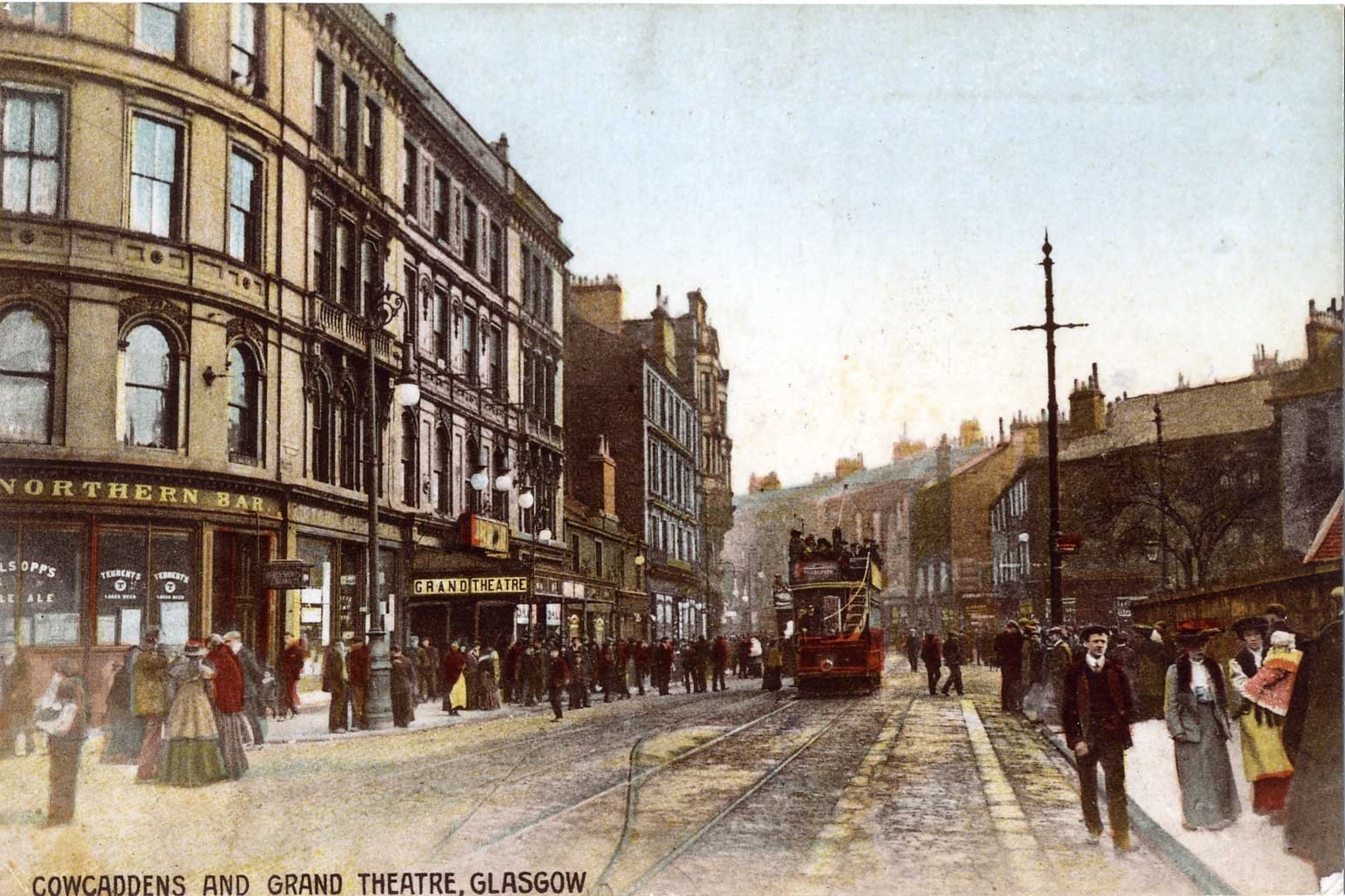
The southern fringes of Cowcaddens have historically housed one of Glasgow's premier entertainment districts, with theatres and cinemas dotted throughout the neighbourhood. Notable venues included: the Theatre Royal on Hope Street;[5] The Royalty Theatre on Sauchiehall and Renfield Streets;[6] The Grand Theatre at Cowcaddens Cross;[7] The Scottish Zoo and Hippodrome on New City Road;[8] The Pavilion Theatre on Renfield Street;[9] Green's Playhouse, later the Apollo music hall on Renfrew Street; The Glasgow Film Theatre on Rose Street; The STV headquarters, built in 1974 on Renfield Street. As of 2021, only the Royal, Pavilion, and GFT remain, and the site of the old Apollo is now home to a Cineworld. Since 1988 the Royal Conservatoire of Scotland's main campus has been on Renfrew Street, with another facility on Garscube Road. The former Cowcaddens Free Church now houses the National Piping Centre.
Housing in the area is primarily ex-council housing (there are no council houses in Glasgow since their transfer to the Glasgow Housing Association).
In 2007 the Cowcaddens pedestrian underpass was decorated with 15 screen prints by artist Ruth Barker.[10]
Cowcaddens Road
Cowcaddens Road appeared on maps since at least 1560,[11] as one continuous road that connected the small village of Cowcaddens to the burgeoning town of Glasgow. This was, until 1766, the Cow Lone, an unpaved road where herders would take their cattle up the hill to Cowcaddens where the animals would graze and be milked in the evening. This path would follow the alignment of current-day Queen Street, veering northwest off of George Square where Queen Street railway station is today. From there, it would join up with Buchanan Street, following toward Port Dundas before turning west into Cowcaddens Street.
The alignment of Cowcaddens Street was altered slightly during a redevelopment beginning in 1968[12] and continuing into the late 1970's.[13] Several tenement blocks were demolished, and the road was brought slightly up the slope of Garnethill, and elevated. This facilitated new connections with Cambridge and Rose Streets, which both previously veered northwest into New City Road instead, as well as a new route into Great Western Road via West Graham Street, another new connection created by this new alignment. Other connections were severed however -- New City Road chiefly among them. Itself vastly transformed by the construction of the M8 motorway, New City Road now leads into an underpass below Cowcaddens Road to the Subway -- all that remains of Cowcaddens Cross. The road was also straightened and lengthened eastward to meet North Hanover Street, through where Buchanan Street railway station once stood. However, the original alignment of Cowcaddens Street is still preserved somewhat in Dundasvale Road, between the National Piping Centre and Garscube Road.
After the redevelopment, Cowcaddens Road passes through the neighbourhood with the traits of a "Stroad", failing to provide any streetspace amenity by plowing through with aggressive traffic, whilst failing to move traffic quickly by allowing too many interweaving connections to the main route, requiring many traffic lights and low speeds for yielding.
Notable People
The socialist politician Edward Hunter, who was instrumental in helping build the Left in New Zealand, was a Labour councillor for Cowcaddens from 1937 until 1959.
Jimmy Barnes and his elder brother John Swan (aka Swanee) spent their early childhood living in Cowcaddens before emigrating to Australia.
See also
- Glasgow tower blocks
References
- List of railway station names in English, Scots and Gaelic – NewsNetScotland Archived 22 January 2013 at the Wayback Machine
- Scott Graham - ABACUS. "TGS - 1830s to 1914 - Neighbourhoods - Cowcaddens". theglasgowstory.com.
- "Maps & Stations - SPT". spt.co.uk.
- "Caledonian University". list.co.uk.
- "The Theatre Royal, 282 Hope Street, Cowcaddens, Glasgow".
- "The Royalty Theatre, Corner of Sauchiehall Street and Renfield Street, Glasgow".
- {{cite web|url=http://www.arthurlloyd.co.uk/Glasgow/MiltonColosseum.htm%7Ctitle=The Milton Colosseum, Cowcaddens Cross, Glasgow
- "The Scottish Zoo and Variety Circus, and Glasgow Hippodrome, New City Road, Glasgow". Arthurlloyd.co.uk. Retrieved 28 December 2018.
- "The Pavilion Thatre, 121 Renfield Street, Glasgow".
- "Cowcaddens Underpass Art". glasgowcanal.co.uk.
- "Sketch plan of the City of Glasgow about 1560 - The Glasgow Story".
- "Cowcaddens Comprehensive Development Area, Phase I -- The University of Edinburgh".
- "Cowcaddens Comprehensive Development Area, Phase II -- The University of Edinburgh".
This Glasgow location article is a stub. You can help Wikipedia by expanding it. |
Другой контент может иметь иную лицензию. Перед использованием материалов сайта WikiSort.org внимательно изучите правила лицензирования конкретных элементов наполнения сайта.
WikiSort.org - проект по пересортировке и дополнению контента Википедии