world.wikisort.org - United_Kingdom
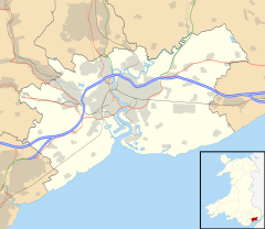
Coedkernew (Welsh: Coedcernyw) is a community in the south west of the city of Newport, South Wales, in the Marshfield ward.
| Coedkernew | |
|---|---|
 Coedkernew Location within Newport | |
| Population | 2,183 (2011 census[1]) |
| OS grid reference | ST280840 |
| Community |
|
| Principal area |
|
| Country | Wales |
| Sovereign state | United Kingdom |
| Post town | NEWPORT |
| Postcode district | NP10 8 |
| Dialling code | 01633 Maesglas and Castleton exchanges |
| Police | Gwent |
| Fire | South Wales |
| Ambulance | Welsh |
| UK Parliament |
|
The parish is bounded by Percoed reen to the south, Nant-y-Selsig to the southwest, and Pound Hill to the west. The northern boundary is formed from Gwern-y-cleppa to junction 28 of the M4, then the A48 Cardiff Road. The eastern boundary is formed from the Ebbw River Bridge roundabout to the west of the International Rectifier plant, Duffryn Drive, along the southern edge of Tredegar House country park, Pencarn Lane and Percoed Lane.
Despite being a mostly rural parish to the south and west, the north and east is a continuation of the Duffryn built-up area, and has seen large increases in population in recent years due to the continued suburbanisation of Newport; it grew from 574 in 2001 to 2,183 in 2011.[1] This built-up area of Coedkernew forms a crescent around Duffryn and as such, much newly built housing in the Duffryn area actually falls within Coedkernew.
This area contains the landmark Coedkernew footbridge over the A48,[2] the giant LG plant, three business parks or industrial parks: Imperial Park,[3] Celtic Springs[4] and Cleppa Park, the Patent Office, Office for National Statistics, Tredegar House as well as the large Celtic Horizons estate and St. Josephs RC High School.
At the northern boundary near Gwern-y-cleppa, the remains of a pre-historic burial chamber can be found which is believed to be neolithic.[5] It is also considered to be one of the possible sites for Early Medieval activity in Gwynllwg, as well as a potential site for the church of Gwladys due to its proximity to the abandoned settlement of Pencarn.
Government
The area is governed by the Newport City Council and the Coedkernew community council.
References
- "Coedkernew population". citypopulation.de. Retrieved 7 September 2018.
- Coedkernew Footbridge:: OS grid ST2784 :: Geograph Britain and Ireland – photograph every grid square!
- Imperial Park, Newport:: OS grid ST2884 :: Geograph Britain and Ireland – photograph every grid square!
- Celtic Springs Business Park, Newport:: OS grid ST2784 :: Geograph Britain and Ireland – photograph every grid square!
- "GWERN-Y-CLEPPA, LONG BARROW | Site Details | Coflein". Archived from the original on 19 May 2012. Retrieved 2 April 2009.
Другой контент может иметь иную лицензию. Перед использованием материалов сайта WikiSort.org внимательно изучите правила лицензирования конкретных элементов наполнения сайта.
WikiSort.org - проект по пересортировке и дополнению контента Википедии
