world.wikisort.org - United_Kingdom
Arnside is a village and civil parish in Cumbria, historically part of Westmorland, near the border with Lancashire, England. The Lake District National Park is located a few miles North. Travelling by road, Arnside is 22 miles (35 km) to the south of Kendal, 25.3 miles (40.7 km) to the east of Ulverston, 35.2 miles (56.6 km) to the east of Barrow-in-Furness, 15.7 miles (25.3 km) to the west of Lancaster and 14.3 miles (23.0 km) to the east of Grange-over-Sands. In the 2001 census the parish had a population of 2,301,[2] increasing at the 2011 census to 2,334.[1]
| Arnside | |
|---|---|
 Arnside on the River Kent | |
| Population | 2,334 (2011)[1] |
| OS grid reference | SD4578 |
| Civil parish |
|
| District | |
| Shire county | |
| Region | |
| Country | England |
| Sovereign state | United Kingdom |
| Post town | CARNFORTH |
| Postcode district | LA5 |
| Dialling code | 01524 |
| Police | Cumbria |
| Fire | Cumbria |
| Ambulance | North West |
| UK Parliament | |


It faces the estuary of the River Kent on the north-eastern corner of Morecambe Bay, within the Arnside and Silverdale Area of Outstanding Natural Beauty and is overlooked by Arnside Knott, a hill that rises out of the estuary. Up to the 19th century, the village was a port, but building the viaduct caused the estuary to silt up.[citation needed] A detailed account of the wildlife of the Arnside and Silverdale AONB is provided by John Wilson and Peter Lennon.[3] Mammals include red squirrel and otter, breeding birds at the time of publication included the bittern which is still found in the area.
Buildings

The oldest building in the parish is Arnside Tower, a Peel tower built in the 14th/15th century as a refuge against raids from Scots and the Border Reivers.
The now defunct Arnside Golf Club was founded in 1906, the club closed around World War II.[4]
Arnside viaduct
The railway line is carried over the River Kent on a viaduct 552 yards (505 m) long, it was built in 1857 and rebuilt in 1915.[5]
Governance
Arnside is part of the Westmorland and Lonsdale parliamentary constituency, of which Tim Farron is the current MP representing the Liberal Democrats.[6][7]
Before Brexit, it was in the North West England European Parliamentary Constituency.
For Local Government purposes, it is in the Arnside + Milnthorpe Ward of South Lakeland District Council and the Kent Estuary Division of Cumbria County Council.
The village has its own Parish Council; Arnside Parish Council.[8]
Transport
Arnside has its own railway station; Arnside railway station, which lies on the Furness Line giving connections to Lancaster, Barrow-in-Furness, Ulverston, Grange-over-Sands, Carnforth and Carlisle. The Furness Line passes over the River Kent via the Arnside Viaduct.
The village is connected to Kendal by the 551 and 552 bus services.[citation needed]
Tides
| This video size: 360x240 500 kbit/s |
| Alternative size: 720x480 2000 kbit/s |
With each high tide, the coast of Arnside is subjected to a very fast rising tide. Because of the potential danger warning notices are posted at the pier, and an audible warning is sounded before every high tide (in daylight). The sequence of warnings is:-
- Eight sounds on the siren - around 2.25 h before high tide
- Eight sounds on the siren - around 1.75 h before high tide
- Twelve sounds on the siren - around 1.25 h before high tide, when the incoming tide is just visible from the Coastguard station (location of the siren 54.199°N 2.841°W )
The cause of this fast tide is a combination of the large area of Morecambe Bay, which narrows rapidly at Arnside, plus the second highest tidal range (at Barrow-in-Furness, which can be as much as 32 feet (9.8 m) on a spring tide nearest the spring and autumn equinox: these typically give rise to a tidal bore, which may be as high as 12 inches (30 cm), and are often used by canoeists.[9]
Notable people
- Robert Wilson (1922-1980), first-class cricketer and Royal Air Force officer
See also
- Listed buildings in Arnside
- St James' Church, Arnside
Image gallery
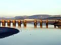 Railway viaduct over the Kent estuary near Arnside

References
- UK Census (2011). "Local Area Report – Arnside Parish (E04002442)". Nomis. Office for National Statistics. Retrieved 25 April 2021.
- UK Census (2001). "Local Area Report – Arnside Parish (16UG003)". Nomis. Office for National Statistics. Retrieved 25 April 2021.
- John Wilson and Peter Lennon 'The Wildlife of the Arnside-Silverdale Area' 1978
- "Arnside Golf Club", "Golf's Missing Links".
- "Arnside station and viaduct". VisitCumbria.com. Retrieved 18 April 2013.
- "Tim Farron". theyworkforyou.com. Archived from the original on 1 June 2013.
- "Westmorland & Lonsdale general election 2019".
- "Arnside Parish Council".
- "The Arnside Bore". Archived from the original on 11 September 2011. Retrieved 13 January 2009.
External links
- Arnside Gateway - local on-line resources
- Arnside Photos Photos of Arnside
- Cumbria County History Trust: Arnside (nb: provisional research only – see Talk page)
- On an 1862 "6 inch" map. This is from the Ordnance Survey of Westmorland. (The view on the 1848-1850 map of Lancashire and Furness is misleading - it was outside the surveyors' area and they have left it as an outline only.)
Places adjacent to Arnside | ||||||||||||||||
|---|---|---|---|---|---|---|---|---|---|---|---|---|---|---|---|---|
| ||||||||||||||||
Authority control | |
|---|---|
| General | |
| National libraries | |
Другой контент может иметь иную лицензию. Перед использованием материалов сайта WikiSort.org внимательно изучите правила лицензирования конкретных элементов наполнения сайта.
WikiSort.org - проект по пересортировке и дополнению контента Википедии