world.wikisort.org - Ukraine
Sobornyi District (Ukrainian: Соборний район) is an urban district of the city of Dnipro, in southern Ukraine.[3] It is located in the city's center on the right-bank of the Dnieper River.
Sobornyi District
Соборний район | |
|---|---|
Urban district | |
 Coat of arms | |
| Coordinates: 48°27′00″N 35°04′00″E | |
| Country | |
| Municipality | Dnipro Municipality |
| Established | 16 March 1936[1] |
| Government | |
| • Chairman of District Council | Anton Zhosul |
| Area | |
| • Total | 44.093 km2 (17.024 sq mi) |
| Population (2001 census) | |
| • Total | 167,645 |
| • Density | 3,800/km2 (9,800/sq mi) |
| Time zone | UTC+2 (EET) |
| • Summer (DST) | UTC+3 (EEST) |
| Area code | +380 562 |
| KOATUU | 1210136900[2] |
| Website | sobornarada |
 |
History
According to archeological finds, in the Paleolithic period (7—3 thousand Anno Domini) human settlements appear on Monastyrskyi Island; which is located in Sobornyi District.[4] Traces of Cimmerian settlements during the Bronze age have been found near today's Sobornyi District's Taras Shevchenko Park.[4]
The current district Sobornyi District was created on 16 March 1936 out of the Kirovskyi and Fabrychno-Chechelivskyi districts.[1] In 1973, a portion of its territory was annexed to the newly created Babushkinskyi District. Before 26 November 2015 the district was named Zhovtnevyi (Ukrainian: Жовтневий район); on that day the district was renamed to comply with decommunization laws.[5][6]
Neighborhoods
- Nahirny
- Laherny
- Vuzivsky
- Mandrykivka
- Lotskamianka
- Peremoha
- Sokil
Gallery
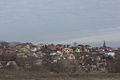 View of a part of Sobornyi District
 Peremoha microdistrict is a part of Sobornyi District
 Sicheslav Embankment in Sobornyi district, Dnipro
 Monastyrskyi Island with a church and steep cliffs
![Panorama view of Nahirniy [uk] neighbourhood](//upload.wikimedia.org/wikipedia/commons/thumb/4/48/%D0%92%D0%B8%D0%B4_%D0%BD%D0%B0_%22%D0%9D%D0%B0%D0%B3%D1%96%D1%80%D0%BD%D1%83%22_%D1%87%D0%B0%D1%81%D1%82%D0%B8%D0%BD%D1%83_%D0%BC%D1%96%D1%81%D1%82%D0%B0_%D0%B7_%D0%BB%D1%96%D0%B2%D0%BE%D0%B3%D0%BE_%D0%B1%D0%B5%D1%80%D0%B5%D0%B3%D1%83.jpg/120px-%D0%92%D0%B8%D0%B4_%D0%BD%D0%B0_%22%D0%9D%D0%B0%D0%B3%D1%96%D1%80%D0%BD%D1%83%22_%D1%87%D0%B0%D1%81%D1%82%D0%B8%D0%BD%D1%83_%D0%BC%D1%96%D1%81%D1%82%D0%B0_%D0%B7_%D0%BB%D1%96%D0%B2%D0%BE%D0%B3%D0%BE_%D0%B1%D0%B5%D1%80%D0%B5%D0%B3%D1%83.jpg) Panorama view of Nahirniy neighbourhood
Panorama view of Nahirniy neighbourhood![Khrushchyovkas on Gagarina Avenue [uk; ru]](//upload.wikimedia.org/wikipedia/commons/thumb/e/e0/%D0%9F%D1%80%D0%BE%D1%81%D0%BF._%D0%93%D0%B0%D0%B3%D0%B0%D1%80%D0%B8%D0%BD%D0%B0%2C_%D0%B4%D0%BE%D0%BC_99._-_panoramio.jpg/120px-%D0%9F%D1%80%D0%BE%D1%81%D0%BF._%D0%93%D0%B0%D0%B3%D0%B0%D1%80%D0%B8%D0%BD%D0%B0%2C_%D0%B4%D0%BE%D0%BC_99._-_panoramio.jpg) Khrushchyovkas on Gagarina Avenue
Khrushchyovkas on Gagarina Avenue


![Panorama view of Nahirniy [uk] neighbourhood](http://upload.wikimedia.org/wikipedia/commons/4/48/%D0%92%D0%B8%D0%B4_%D0%BD%D0%B0_%22%D0%9D%D0%B0%D0%B3%D1%96%D1%80%D0%BD%D1%83%22_%D1%87%D0%B0%D1%81%D1%82%D0%B8%D0%BD%D1%83_%D0%BC%D1%96%D1%81%D1%82%D0%B0_%D0%B7_%D0%BB%D1%96%D0%B2%D0%BE%D0%B3%D0%BE_%D0%B1%D0%B5%D1%80%D0%B5%D0%B3%D1%83.jpg)
![Khrushchyovkas on Gagarina Avenue [uk; ru]](http://upload.wikimedia.org/wikipedia/commons/e/e0/%D0%9F%D1%80%D0%BE%D1%81%D0%BF._%D0%93%D0%B0%D0%B3%D0%B0%D1%80%D0%B8%D0%BD%D0%B0%2C_%D0%B4%D0%BE%D0%BC_99._-_panoramio.jpg)
References
- "History of the Zhovtnevyi Raion". Council of the Zhovtnevyi Raion of the city of Dnipropetrovsk (in Ukrainian). Archived from the original on 2016-08-29. Retrieved 4 February 2015.
- "Zhovtnevyi District Council". Informational portal of the self-government in Ukraine (in Ukrainian). Rada.info. Retrieved 5 February 2015.
- "Zhovtnevyi Raion, Dnipropetrovsk Oblast, City of Dnipropetrovsk". Regions of Ukraine and their Structure (in Ukrainian). Verkhovna Rada of Ukraine. Retrieved 4 February 2015.
- Yuri Pakhomenkov (2000). "History of Nadporizhe - Prydniprovye (from the first people to the 17th century)". gorod.dp.ua (in Ukrainian). Retrieved 16 October 2022.
- (in Ukrainian) Street signs were Dnipropetrovsk nedekomunizovanymy, Radio Svoboda (2 December 2015)
- "In Dnepropetrovsk, the main highways and five districts of the city were renamed" (in Ukrainian). depo.ua. Retrieved 27 November 2015.
External links
- Official website (in Ukrainian)
| Districts | |||||
|---|---|---|---|---|---|
| Urban-type settlements | |||||
| Neighborhoods |
| ||||
| |||||
This article about a location in Dnipropetrovsk Oblast is a stub. You can help Wikipedia by expanding it. |
Другой контент может иметь иную лицензию. Перед использованием материалов сайта WikiSort.org внимательно изучите правила лицензирования конкретных элементов наполнения сайта.
WikiSort.org - проект по пересортировке и дополнению контента Википедии