world.wikisort.org - Ukraine
Samarskyi District (Ukrainian: Самарський район) is an urban district of the city of Dnipro, in southern Ukraine.[4] It is located at the confluence of the Dnieper and Samara rivers in the eastern and southeastern parts of the city.
Samarskyi District
Самарський район | |
|---|---|
Urban district | |
| Coordinates: 48°25′01″N 35°07′04″E | |
| Country | |
| Municipality | Dnipro Municipality |
| Established | 6 April 1977[1] |
| Area | |
| • Total | 66.83 km2 (25.80 sq mi) |
| Population (2001 census) | |
| • Total | 78,997 |
| • Density | 1,200/km2 (3,100/sq mi) |
| Time zone | UTC+2 (EET) |
| • Summer (DST) | UTC+3 (EEST) |
| Area code | +380 562 |
| KOATUU | 1210138400[3] |
|
 |
History
The district was created on 6 April 1977[5] out of the neighborhood of Samar previously in the Industrialnyi District and the newly added cities of Prydniprovsk (1956–1977) and Ihren (1959–1977) as well as a historic Cossack settlement of Chapli.[1][5] Archeologic founds suggest that Samar existed in 1524.[6] Archaeologists of the Dnipro National University have discovered artifacts there dated around 1520s.[7]
The town of Prydniprovsk was created around the Prydniprovsk State District Power Station (DRES), today a thermal power station that was built in 1954, while the town of Ihren was created around the Ihren Rail Station, which still exists since 1873.[5] They were both absorbed into the boundaries of the Samarskyi District.[5]
Neighborhoods
- Chapli
- Ihren
- Kseniivka
- Nyzhnodniprovsk-Vuzol
- Odynkivka
- Pivnichnyi
- Prydniprovsk
- Samar, Dnipro
- Shevchenko
- Stara Ihren
Gallery
 Prydniprovsk Power Plant
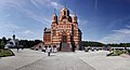 Church
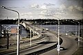 South bridge


References
- "Samarskyi Raion". Official Internet-portal (in Ukrainian). Dnipro City Council. Archived from the original on 8 February 2012. Retrieved 4 February 2015.
- "Samarskyi Raion". gorod.dp.ua/ (in Ukrainian). Retrieved 4 February 2015.
- "Samarskyi District Council". Informational portal of the self-government in Ukraine (in Ukrainian). Rada.info. Retrieved 5 February 2015.
- "Samarskyi Raion, Dnipropetrovsk Oblast, City of Dnipropetrovsk". Regions of Ukraine and their Structure (in Ukrainian). Verkhovna Rada of Ukraine. Retrieved 4 February 2015.
- "Historical Background of Samarskyi District" (in Ukrainian). Dnipro city council. Retrieved 5 October 2021.
- (in Ukrainian) Dnipro: pages of the city's history. The first page is Cossack, dnipro.libr.dp.ua (21 September 2017)
- (in Ukrainian) Iryna Reva, Oleh Rypan. The Old Samar (Cтара Cамар). The Ukrainian Week. 18 July 2011
External links
- Samarskyi District at the Dnipro City Council website (in Ukrainian)
| Districts |
| ||||
|---|---|---|---|---|---|
| Urban-type settlements |
| ||||
| Neighborhoods |
| ||||
| |||||
This article about a location in Dnipropetrovsk Oblast is a stub. You can help Wikipedia by expanding it. |
Другой контент может иметь иную лицензию. Перед использованием материалов сайта WikiSort.org внимательно изучите правила лицензирования конкретных элементов наполнения сайта.
WikiSort.org - проект по пересортировке и дополнению контента Википедии