world.wikisort.org - Turkmenistan
Baýramaly (formerly Bayram-Ali, Turkmen: Baýramaly, earlier Bahrām Ali [1]) is a city in and the seat of Baýramaly District, Mary Province, Turkmenistan. It lies about 27 km east of the provincial capital Mary, along the main railway line from Ashgabat to Tashkent. In 2009, its population was estimated at 88,486 (up from 43,824 in the 1989 census).[2]
Baýramaly | |
|---|---|
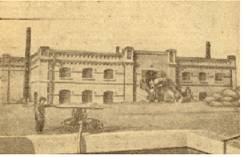 Baýramaly in the late 1800s | |
 Baýramaly Location in Turkmenistan | |
| Coordinates: 37°37′N 62°09′E | |
| Country | |
| Province | Mary Province |
| District | Baýramaly District |
| Elevation | 233 m (764 ft) |
| Population (2009) | |
| • Total | 88,486 |
| Time zone | UTC+5 (+5) |
Etymology
Baýramaly is a masculine name. It is named after Bayram 'Ali Khan Qajar, the most prominent ruler of the Qajar Principality of Merv.[3] According to Atanyyazow, Bayramaly ruled Mary in the 18th century, from 1782 to 1785.[4] However, the actual length of his reign remains disputed.[5]
Overview
The city is located in a dry oasis formed by the Murghab River. Baýramaly is a climatic spa and visitors are often sent to the city for treatment of chronic kidney disease, acute forms of nephritis and nephrosis, hypertension, renal tuberculosis, and problems of blood circulation.[6] The Baýramaly Sanitorium (Turkmen: Baýramaly Şypahanasy) has been in operation since 1933. In 2010 the sanitorium underwent renovation and two new buildings were added. The sanitorium specializes in ailments of the kidneys and urinary tract, diseases of the cardiovascular system, and diseases of the musculoskeletal system.[7]
Climate
Baýramaly has a cold semi-arid climate (Köppen climate classification BSk), with cool winters and very hot summers. Rainfall is generally light and erratic, and occurs mainly in the winter and autumn months.
| Climate data for Baýramaly | |||||||||||||
|---|---|---|---|---|---|---|---|---|---|---|---|---|---|
| Month | Jan | Feb | Mar | Apr | May | Jun | Jul | Aug | Sep | Oct | Nov | Dec | Year |
| Record high °C (°F) | 28.0 (82.4) |
31.8 (89.2) |
37.0 (98.6) |
40.5 (104.9) |
50.0 (122.0) |
50.0 (122.0) |
47.5 (117.5) |
45.7 (114.3) |
44.0 (111.2) |
39.6 (103.3) |
35.2 (95.4) |
29.0 (84.2) |
50.0 (122.0) |
| Average high °C (°F) | 8.4 (47.1) |
11.4 (52.5) |
16.9 (62.4) |
24.7 (76.5) |
31.4 (88.5) |
36.2 (97.2) |
38.1 (100.6) |
36.1 (97.0) |
31.0 (87.8) |
24.1 (75.4) |
16.8 (62.2) |
10.3 (50.5) |
23.8 (74.8) |
| Daily mean °C (°F) | 1.9 (35.4) |
4.6 (40.3) |
9.9 (49.8) |
17.2 (63.0) |
23.6 (74.5) |
28.5 (83.3) |
30.5 (86.9) |
28.1 (82.6) |
22.1 (71.8) |
15.0 (59.0) |
8.7 (47.7) |
4.0 (39.2) |
16.2 (61.1) |
| Average low °C (°F) | −2.7 (27.1) |
−0.5 (31.1) |
4.1 (39.4) |
10.2 (50.4) |
15.3 (59.5) |
19.5 (67.1) |
21.7 (71.1) |
19.2 (66.6) |
12.9 (55.2) |
7.0 (44.6) |
2.1 (35.8) |
−1.0 (30.2) |
9.0 (48.2) |
| Record low °C (°F) | −26.3 (−15.3) |
−24.8 (−12.6) |
−16.8 (1.8) |
−3.6 (25.5) |
2.2 (36.0) |
7.6 (45.7) |
11.7 (53.1) |
7.4 (45.3) |
−1.8 (28.8) |
−8.3 (17.1) |
−21.5 (−6.7) |
−23.0 (−9.4) |
−26.3 (−15.3) |
| Average precipitation mm (inches) | 28.7 (1.13) |
24.9 (0.98) |
35.3 (1.39) |
26.0 (1.02) |
13.3 (0.52) |
1.1 (0.04) |
0.1 (0.00) |
0.1 (0.00) |
0.8 (0.03) |
6.7 (0.26) |
13.6 (0.54) |
23.2 (0.91) |
173.8 (6.82) |
| Average precipitation days (≥ 0.1 mm) | 7.2 | 6.2 | 5.9 | 3.8 | 2.3 | 0.5 | 0.2 | 0.3 | 0.3 | 2.2 | 5.1 | 6.1 | 40.1 |
| Average relative humidity (%) | 73.5 | 67.3 | 57.7 | 51.6 | 40.6 | 31.7 | 30.3 | 29.4 | 34.7 | 46.1 | 63.1 | 72.8 | 49.9 |
| Mean monthly sunshine hours | 129.7 | 137.4 | 168.9 | 217.2 | 304.7 | 356.2 | 371.7 | 355.0 | 302.4 | 249.0 | 185.1 | 128.7 | 2,906 |
| Source 1: climatebase.ru[8] | |||||||||||||
| Source 2: NOAA (sun only, 1961-1990)[9] | |||||||||||||
Economy
The economy is based around food and construction materials industries.[6] Natural gas is also extracted in the area.
Sights
- Close to Baýramaly are the ruins of ancient Merv.
- 28 kilometres (17 mi) to the north is the mausoleum of Hudaýnazar Öwlüýä (early 12th century).[6]
Notable people
- Mähri Hojaniyazova
- Nury Halmammedov
- Suleyman Nazarov Berdiyevich
- Dzhamaldin Khodzhaniyazov
- Alvina Shpady
References
- 1929 Soviet Turkmenistan map
- Population census 1989 Archived 2012-01-18 at the Wayback Machine, Demoscope Weekly, No. 359-360, 1–18 January 2009 (search for Туркменская ССР) (in Russian)
- "The Sariq Turkmens of Merv and the Khanate of Khiva in the early nineteenth century - ProQuest". www.proquest.com. Retrieved 2022-06-02.
- Atanyýazow, Soltanşa (1980). Түркменистаның Географик Атларының Дүшүндиришли Сөзлүги [Explanatory Dictionary of Geographic Names in Turkmenistan]. Ashgabat: Ылым. p. 54.
- The length of his reign is disputed. Mir 'Abd al-Karim Bukhari states he reigned from 1782 to 1785. However, William Wood considers that to be a typo; Bayram 'Ali Khan's son, Hajji Mohammad Husayn, states he either reigned for 31 years or 50 years. Mohammad Sadeq Mervezi states that Bayram 'Ali Khan was chosen by the local leaders to lead after the collapse of the Afsharids (sometime after 1747). Christine Noelle-Karimi doesn't give a specific date, but mentions that Bayram 'Ali Khan's father Shah Qoli Beg Qajar was appointed governor in c.1741, and that by 1751 'Ali Naqi Khan Qajar was ruler of Merv before it switched to Bayram 'Ali Khan.
- Great Soviet Encyclopedia (in Russian)
- ""Baýramaly" şypahanasy" (in Turkmen). Turkmenportal. 1 September 2012.
- "Bayram-Ali, Turkmenistan". Climatebase.ru. Retrieved 10 February 2013.
- "Climate Normals for Bayramaly". National Oceanic and Atmospheric Administration. Retrieved 10 February 2013.
Capital: Ashgabat | |
|
На других языках
[de] Baýramaly
Baýramaly (russisch Байрамали .mw-parser-output .Latn{font-family:"Akzidenz Grotesk","Arial","Avant Garde Gothic","Calibri","Futura","Geneva","Gill Sans","Helvetica","Lucida Grande","Lucida Sans Unicode","Lucida Grande","Stone Sans","Tahoma","Trebuchet","Univers","Verdana"}Bairamali) ist mit 91.713 Einwohnern die sechstgrößte Stadt Turkmenistans[1]. Sie liegt 390 km östlich der Hauptstadt Aşgabat in der Provinz Mary an der Transkaspischen Eisenbahn und an der Europastraße 60. Die Wirtschaft stützt sich auf die Lebensmittel- und Baustoffindustrie. Außerdem wird in der Region Erdgas gefördert.- [en] Baýramaly
[ru] Байрамали
Байрамали[2] (туркм. Baýramaly) — город в Марыйском велаяте Туркмении. Расположен в Мургабском оазисе, в 375 км к востоку от Ашхабада. Хяким — Какамырат Аманмырадов (2013)[3].Другой контент может иметь иную лицензию. Перед использованием материалов сайта WikiSort.org внимательно изучите правила лицензирования конкретных элементов наполнения сайта.
WikiSort.org - проект по пересортировке и дополнению контента Википедии