world.wikisort.org - Turkey
Karabük is a town and the capital district of Karabük Province in the Black Sea region of Turkey. According to the 2009 census, population of the city is 108 167.[3][4] The district covers an area of 760 km2 (293 sq mi),[5] and the town lies at an elevation of 354 m (1,161 ft).
Karabük | |
|---|---|
Municipality | |
 | |
 Karabük  Karabük  Karabük  Karabük | |
| Coordinates: 41°11′55″N 32°37′35″E | |
| Country | Turkey |
| Province | Karabük |
| Government | |
| • Mayor | Rafet Vergili (MHP) |
| Area | |
| • District | 759.63 km2 (293.29 sq mi) |
| Population (2012)[2] | |
| • Urban | 110,537 |
| • District | 123,616 |
| • District density | 160/km2 (420/sq mi) |
| Climate | Cfa |
| Website | www.karabuk.bel.tr |
Karabük was built in the 1930s as the seat of the iron and steel industry of Turkey. Thus it has one of the worst- if not the worst - air pollution in the country, with a hazardous Air Quality Index of 328.[6] Karabük lies in a location near Filyos River formed by the merge of Araç and Soğanlı rivers.
Name
There are no known records of the origin of its name; in Turkish kara means "black" or "land" and bük means "bush" or "blackberry bush" ("bramble"). So Karabük means "blackbush".
History
Karabük is situated on an important trade route between Amasra on the coast and central Anatolia. The history of the city goes back to the early years of the Turkish Republic, when it was a small sub-village formed by 13 houses in the Öğlebeli village of Safranbolu. There was also a small train station on the Ankara–Zonguldak route. The town started to develop with the industrialization of the country. One of the first steel factories of the Republic was built here in 1939, after which it grew rapidly and incorporated Öğlebeli village as a quarter. Karabük became a municipality and then a township in the Safranbolu district in 1941. It became a district center in 1953 and a provincial center in 1995.
Hadrianapolis (now Eskipazar), is an ancient city from the Roman Empire of the 4th century, located about 3 km from Karabük. There are many fountains, churches, and Roman baths. Although most of it is recently excavated, illegal excavations which have been going on for many years and have damaged Eskipazar's chances of becoming a major tourist attraction.[7]
Climate
Karabük has a humid subtropical climate (Köppen: Cfa) or a relatively warm oceanic climate (Trewartha: Do) with hot, humid summers and chilly, wet winters.
| Climate data for Karabük (1991–2020, extremes 1965–2020) | |||||||||||||
|---|---|---|---|---|---|---|---|---|---|---|---|---|---|
| Month | Jan | Feb | Mar | Apr | May | Jun | Jul | Aug | Sep | Oct | Nov | Dec | Year |
| Record high °C (°F) | 20.1 (68.2) |
23.5 (74.3) |
29.7 (85.5) |
32.4 (90.3) |
37.0 (98.6) |
37.6 (99.7) |
41.4 (106.5) |
39.6 (103.3) |
40.9 (105.6) |
33.3 (91.9) |
26.9 (80.4) |
19.3 (66.7) |
41.4 (106.5) |
| Average high °C (°F) | 7.3 (45.1) |
12.2 (54.0) |
16.3 (61.3) |
21.1 (70.0) |
24.7 (76.5) |
28.6 (83.5) |
31.7 (89.1) |
32.8 (91.0) |
29.2 (84.6) |
22.3 (72.1) |
15.0 (59.0) |
9.0 (48.2) |
20.8 (69.4) |
| Daily mean °C (°F) | 2.3 (36.1) |
5.8 (42.4) |
8.8 (47.8) |
12.2 (54.0) |
16.8 (62.2) |
20.5 (68.9) |
23.3 (73.9) |
23.9 (75.0) |
20.2 (68.4) |
14.6 (58.3) |
8.1 (46.6) |
3.9 (39.0) |
13.4 (56.1) |
| Average low °C (°F) | −0.9 (30.4) |
1.5 (34.7) |
3.4 (38.1) |
5.4 (41.7) |
10.8 (51.4) |
14.6 (58.3) |
16.3 (61.3) |
16.7 (62.1) |
13.5 (56.3) |
9.5 (49.1) |
3.6 (38.5) |
0.7 (33.3) |
7.9 (46.2) |
| Record low °C (°F) | −11.5 (11.3) |
−11.8 (10.8) |
−4.8 (23.4) |
−2.1 (28.2) |
0.5 (32.9) |
0.7 (33.3) |
10.4 (50.7) |
10.8 (51.4) |
4.6 (40.3) |
0.8 (33.4) |
−5.4 (22.3) |
−10.9 (12.4) |
−11.8 (10.8) |
| Average precipitation mm (inches) | 44.1 (1.74) |
41.8 (1.65) |
42.9 (1.69) |
38.1 (1.50) |
66.3 (2.61) |
82.0 (3.23) |
22.6 (0.89) |
18.0 (0.71) |
31.4 (1.24) |
50.7 (2.00) |
34.9 (1.37) |
49.3 (1.94) |
522.1 (20.56) |
| Average precipitation days | 14.29 | 12.71 | 13.43 | 11.14 | 15.71 | 15.57 | 5.71 | 5.43 | 7.14 | 10.71 | 10.71 | 13.86 | 136.4 |
| Mean monthly sunshine hours | 58.9 | 93.2 | 139.5 | 216.0 | 198.4 | 225.0 | 291.4 | 282.1 | 222.0 | 164.3 | 126.0 | 77.5 | 2,094.3 |
| Mean daily sunshine hours | 1.9 | 3.3 | 4.5 | 7.2 | 6.4 | 7.5 | 9.4 | 9.1 | 7.4 | 5.3 | 4.2 | 2.5 | 5.7 |
| Source: Turkish State Meteorological Service[8] | |||||||||||||
Economy
Karabük has its own resources of dolomite and limestone, while coal and manganese is brought from Zonguldak and iron ore from Divriği. This allows a varied, yet basic industry in Karabük, including a coking plant, blast furnaces, a foundry and tube works. There are also chemical plants that produce sulfuric acid and phosphates. Nearby are the Zonguldak coal fields.
One of the major steel producers in Turkey, namely Kardemir (Karabük Iron and Steel Works), is located in Karabük.
Gallery
 Karabük station
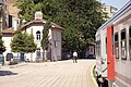 Karabük station
 Karabük general view
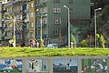 Karabük general view
 Karabük otogar
 Kaymakamlar Museum
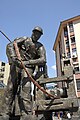 Karabük labourers monument
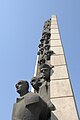 Karabük Atatürk monument
 Karabük at railroad
 Karabük view


Notes
- "Area of regions (including lakes), km²". Regional Statistics Database. Turkish Statistical Institute. 2002. Retrieved 2013-03-05.
- "Population of province/district centers and towns/villages by districts - 2012". Address Based Population Registration System (ABPRS) Database. Turkish Statistical Institute. Retrieved 2013-02-27.
- Archived 2013-08-01 at the Wayback Machine
- GeoHive. "Statistical information on Turkey's administrative units". Retrieved 2008-11-20.
- Statoids. "Statistical information on districts of Turkey". Retrieved 2008-11-20.
- aqicn.org 25 February 2020
- Ramazan Uyumaz. "The Antique City of Hadrianapolis (Turkish)". Retrieved 2011-03-11.
- "Resmi İstatistikler: İllerimize Ait Mevism Normalleri (1991–2020)" (in Turkish). Turkish State Meteorological Service. Retrieved 6 July 2021.
References
- Falling Rain Genomics, Inc. "Geographical information on Karabük, Turkey". Retrieved 2008-11-19.
External links
- District governor's official web site (in Turkish)
- Karabük Haber Sitesi (in Turkish)
- Karabük Internet Magazine (in Turkish)
- Kardemir official web site (in English)
- University Of Karabük (in Turkish)
- Karabük Municipality (in Turkish)
- University Of Karabük (in Turkish)
Karabük in Karabük Province of Turkey | |||||||||||||||||||||||||||
|---|---|---|---|---|---|---|---|---|---|---|---|---|---|---|---|---|---|---|---|---|---|---|---|---|---|---|---|
| Districts |
|   | |||||||||||||||||||||||||
||
Metropolitan municipalities are bolded. | |||||||||||||||||||||||||||
| Authority control: National libraries |
|---|
На других языках
- [en] Karabük
[ru] Карабюк
Карабюк (тур. Karabük) — город и район в Турции, административный центр ила Карабюк. Находится в 200 км к северу от Анкары и в 115 км к юго-востоку от Зонгулдака. В Карабюке расположен один из крупнейших производителей стали в Турции - «Kardemir».Другой контент может иметь иную лицензию. Перед использованием материалов сайта WikiSort.org внимательно изучите правила лицензирования конкретных элементов наполнения сайта.
WikiSort.org - проект по пересортировке и дополнению контента Википедии