world.wikisort.org - Thailand
Phon Phisai (Thai: โพนพิสัย, pronounced [pʰōːn pʰí.sǎj]) is a district (amphoe) in Nong Khai province, northeastern Thailand.
Phon Phisai
โพนพิสัย | |
|---|---|
District | |
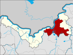 District location in Nong Khai province | |
| Coordinates: 18°1′19″N 103°4′38″E | |
| Country | Thailand |
| Province | Nong Khai |
| Area | |
| • Total | 642.7 km2 (248.1 sq mi) |
| Population (2008) | |
| • Total | 96,580 |
| • Density | 149.1/km2 (386/sq mi) |
| Time zone | UTC+7 (ICT) |
| Postal code | 43120 |
| Geocode | 4305 |
History
The district was originally part of Mueang Phon Phaeng, now part of Rattanawapi district. In 1906 it was established as a district.
Geography
Neighboring districts are (from the east clockwise) Rattanawapi and Fao Rai of Nong Khai Province; Ban Dung, Sang Khom, and Phen of Udon Thani province; and Mueang Nong Khai of Nong Khai. To the north across the Mekong River are the Laotian Vientiane Prefecture and Bolikhamxai province.
Administration
The district is divided into 11 sub-districts (tambons), which are further subdivided into 151 villages (mubans). Chumphon is a sub-district municipality (thesaban tambon) which covers parts of tambon Chumphon. There are a further 11 tambon administrative organizations (TAO).
| No. | Name | Thai | Villages | Pop.[1] |
|---|---|---|---|---|
| 1. | Chumphon | จุมพล | 24 | 19,738 |
| 2. | Wat Luang | วัดหลวง | 16 | 9,200 |
| 3. | Kut Bong | กุดบง | 14 | 8,681 |
| 4. | Chum Chang | ชุมช้าง | 19 | 9,498 |
| 6. | Thung Luang | ทุ่งหลวง | 12 | 5,172 |
| 7. | Lao Tang Kham | เหล่าต่างคำ | 13 | 6,376 |
| 8. | Na Nang | นาหนัง | 16 | 11,129 |
| 9. | Soem | เซิม | 10 | 7,426 |
| 13. | Ban Pho | บ้านโพธิ์ | 12 | 10,281 |
| 21. | Ban Phue | บ้านผือ | 7 | 5,440 |
| 22. | Sang Nang Khao | สร้างนางขาว | 8 | 3,639 |
Missing numbers are tambon which now form the districts Fao Rai and Rattanawapi.
References
- "Population statistics 2008". Department of Provincial Administration. Archived from the original on 2009-08-20. Retrieved 2009-10-11.
External links
- amphoe.com (Thai)
This Nong Khai Province location article is a stub. You can help Wikipedia by expanding it. |
Другой контент может иметь иную лицензию. Перед использованием материалов сайта WikiSort.org внимательно изучите правила лицензирования конкретных элементов наполнения сайта.
WikiSort.org - проект по пересортировке и дополнению контента Википедии