world.wikisort.org - Thailand
Nong Ya Plong (Thai: หนองหญ้าปล้อง, pronounced [nɔ̌ːŋ jâː plɔ̂ŋ]) is a district (amphoe) in the northwestern part of Phetchaburi province, western Thailand.
Nong Ya Plong
หนองหญ้าปล้อง | |
|---|---|
District | |
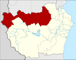 District location in Phetchaburi province | |
| Coordinates: 13°9′47″N 99°41′50″E | |
| Country | Thailand |
| Province | Phetchaburi |
| Seat | Nong Ya Plong |
| Area | |
| • Total | 1,249.8 km2 (482.6 sq mi) |
| Population (2005) | |
| • Total | 14,390 |
| • Density | 11.5/km2 (30/sq mi) |
| Time zone | UTC+7 (ICT) |
| Postal code | 76160 |
| Geocode | 7603 |
History
Nong Ya Plong was established as a minor district (king amphoe) on 16 July 1972, when three tambons, Nong Ya Plong, Yang Nam Klat Nuea, and Yang Nam Klat Tai were split off from Khao Yoi district.[1] It was upgraded to a full district on 21 May 1990.[2]
Geography
Neighboring districts are (from the north clockwise) Ban Kha and Pak Tho of Ratchaburi province, Khao Yoi, Ban Lat, and Kaeng Krachan of Phetchaburi Province. To the west is the Tanintharyi Division of Myanmar.
Administration
The district is divided into four sub-districts (tambons), which are further subdivided into 31 villages (mubans). There are no municipal areas (thesaban), and three tambon administrative organizations (TAO).
| No. | Name | Thai name | Villages | Pop. | |
|---|---|---|---|---|---|
| 1. | Nong Ya Plong | หนองหญ้าปล้อง | 11 | 6,411 | |
| 2. | Yang Nam Klat Nuea | ยางน้ำกลัดเหนือ | 5 | 1,867 | |
| 3. | Yang Nam Klat Tai | ยางน้ำกลัดใต้ | 7 | 2,375 | |
| 4. | Tha Takhro | ท่าตะคร้อ | 8 | 3,737 |
References
- ประกาศกระทรวงมหาดไทย เรื่อง แบ่งท้องที่อำเภอเขาย้อย จังหวัดเพชรบุรี ตั้งเป็นกิ่งอำเภอหนองหญ้าปล้อง (PDF). Royal Gazette (in Thai). 89 (102 ง): 1717. July 4, 1972.
- พระราชกฤษฎีกาตั้งอำเภอห้วยผึ้ง อำเภอวังวิเศษ อำเภอคลองหาด อำเภอป่าบอน อำเภอหนองหญ้าปล้อง อำเภอวังโป่ง อำเภอควนเนียง อำเภอหนองหญ้าไซ อำเภอบ้านนาเดิม อำเภอทุ่งฝน อำเภอสร้างคอม และอำเภอทองแสนขัน พ.ศ. ๒๕๓๓ (PDF). Royal Gazette (in Thai). 107 (83 ก special): 1–4. May 21, 1994.
External links
This Phetchaburi Province location article is a stub. You can help Wikipedia by expanding it. |
Другой контент может иметь иную лицензию. Перед использованием материалов сайта WikiSort.org внимательно изучите правила лицензирования конкретных элементов наполнения сайта.
WikiSort.org - проект по пересортировке и дополнению контента Википедии