world.wikisort.org - Thailand
Mueang Ranong (Thai: เมืองระนอง) is the capital district (amphoe mueang) of Ranong province, southern Thailand.
This article does not cite any sources. (July 2018) |
Mueang Ranong
เมืองระนอง | |
|---|---|
District | |
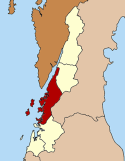 District location in Ranong province | |
| Coordinates: 9°58′2″N 98°38′2″E | |
| Country | Thailand |
| Province | Ranong |
| Seat | Khao Niwet |
| Area | |
| • Total | 713.7 km2 (275.6 sq mi) |
| Population (2005) | |
| • Total | 90,569 |
| • Density | 126.9/km2 (329/sq mi) |
| Time zone | UTC+7 (ICT) |
| Postal code | 85000 |
| Geocode | 8501 |
Geography
Neighboring districts are (from the north clockwise) La-un of Ranong Province, Phato of Chumphon province, and Kapoe of Ranong. To the west across the Kraburi River estuary is the Tanintharyi Division of Myanmar.
Administration
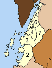
The district is divided into nine sub-districts (tambons), which are further subdivided into 39 villages (muban). The town (thesaban mueang) Ranong covers tambon Khao Niwet. There are three sub-district municipalities (thesaban tambon): Ngao and Pak Nam each cover parts of the same-named tambons, while Bang Rin covers the whole tambon. There are a further seven tambon administrative organization (TAO).
|
 |
External links
- amphoe.com (Thai)
This Ranong Province location article is a stub. You can help Wikipedia by expanding it. |
Другой контент может иметь иную лицензию. Перед использованием материалов сайта WikiSort.org внимательно изучите правила лицензирования конкретных элементов наполнения сайта.
WikiSort.org - проект по пересортировке и дополнению контента Википедии