world.wikisort.org - Thailand
Ban Dan (Thai: บ้านด่าน, pronounced [bâːn dàːn]) is a district (amphoe) of Buriram province, northeastern Thailand.
Ban Dan
บ้านด่าน | |
|---|---|
District | |
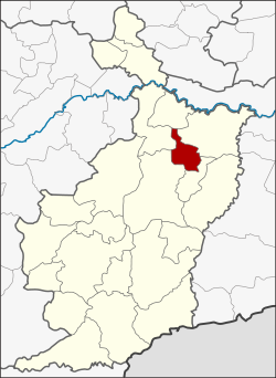 District location in Buriram province | |
| Coordinates: 15°6′26″N 103°10′29″E | |
| Country | Thailand |
| Province | Buriram |
| Seat | Ban Dan |
| Area | |
| • Total | 247.6 km2 (95.6 sq mi) |
| Population (2005) | |
| • Total | 30,548 |
| • Density | 123.4/km2 (320/sq mi) |
| Time zone | UTC+7 (ICT) |
| Postal code | 31000 |
| Geocode | 3121 |
History
The minor district (king amphoe) Ban Dan was created on 15 July 1996 by splitting four tambons from Mueang Buriram district.[1]
On 15 May 2007, all 81 minor districts were upgraded to full districts.[2] With publication in the Royal Gazette on 24 August the upgrade became official.[3]
Geography
Neighboring districts are (from the north clockwise) Khaen Dong, Satuek, Huai Rat, Mueang Buriram and Khu Mueang.
Administration
The district is divided into four sub-districts (tambons), which are further subdivided into 59 villages (mubans). There are no municipal (thesaban) areas. There are a further four tambon administrative organizations.
| No. | Name | Thai name | Villages | Pop. | |
|---|---|---|---|---|---|
| 1. | Ban Dan | บ้านด่าน | 20 | 11,808 | |
| 2. | Prasat | ปราสาท | 18 | 8,791 | |
| 3. | Wang Nuea | วังเหนือ | 12 | 4,327 | |
| 4. | Non Khwang | โนนขวาง | 9 | 5,622 |
References
- ประกาศกระทรวงมหาดไทย เรื่อง แบ่งเขตท้องที่อำเภอเมืองบุรีรัมย์ จังหวัดบุรีรัมย์ ตั้งเป็นกิ่งอำเภอบ้านด่าน (PDF). Royal Gazette (in Thai). 113 (Special 18 ง): 31. June 26, 1996.
- แถลงผลการประชุม ครม. ประจำวันที่ 15 พ.ค. 2550 (in Thai). Manager Online.
- พระราชกฤษฎีกาตั้งอำเภอฆ้องชัย...และอำเภอเหล่าเสือโก้ก พ.ศ. ๒๕๕๐ (PDF). Royal Gazette (in Thai). 124 (46 ก): 14–21. August 24, 2007.
External links
This Buriram Province location article is a stub. You can help Wikipedia by expanding it. |
На других языках
[de] Amphoe Ban Dan
Amphoe Ban Dan (Thai: อำเภอ บ้านด่าน) ist ein Landkreis (Amphoe – Verwaltungs-Distrikt) der Provinz Buri Ram. Die Provinz Buri Ram liegt in der Nordostregion von Thailand, dem so genannten Isan.- [en] Ban Dan district
Другой контент может иметь иную лицензию. Перед использованием материалов сайта WikiSort.org внимательно изучите правила лицензирования конкретных элементов наполнения сайта.
WikiSort.org - проект по пересортировке и дополнению контента Википедии