world.wikisort.org - Tajikistan
Ayni District, also Aini District (Russian: Айнинский район; Tajik: Ноҳияи Айнӣ, Nohiyayi Aynī), is a district in the southern part of Sughd Region, Tajikistan, straddling the middle course of the river Zeravshan. Its capital is the town of Ayni (Tajik: Айнӣ), located on the Zeravshan.[3] The population of the district is 83,600 (January 2020 estimate).[1] It was named after the Tajik national poet Sadriddin Ayni (Tajik: Садриддин Айнӣ). India established a base at Ayni in Tajikistan, which was used to assist the Northern Alliance during the Taliban regime.
Ayni District
| |
|---|---|
District | |
 Ayni District Landscape | |
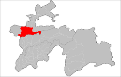 Location of Ayni District in Tajikistan | |
| Coordinates: 39°20′N 68°35′E | |
| Country | |
| Region | Sughd Region |
| Capital | Ayni |
| Area | |
| • Total | 5,200 km2 (2,000 sq mi) |
| Population (Jan. 2020)[1] | |
| • Total | 83,600 |
| Time zone | UTC+5 (TJT) |
| Postal code | 735520 |
| Area code(s) | +992 3479 |
| Official languages | |
| Website | www |
Administrative divisions
The district has an area of about 5,200 km2 (2,000 sq mi) and is divided administratively into one town and seven jamoats.[4] They are as follows:[5]
| Jamoat | Population (Jan. 2015)[5] |
|---|---|
| Zarafshan (town) | 2,200[6] |
| Anzob | 8,238 |
| Ayni | 14,862 |
| Dardar | 7,562 |
| Fondaryo | 9,478 |
| Rarz | 8,998 |
| Shamtuch | 6,557 |
| Urmetan | 18,016 |
References
- "Population of the Republic of Tajikistan as of 1 January 2020" (PDF) (in Russian). Statistics office of Tajikistan. Retrieved 12 October 2020.
- "КОНСТИТУЦИЯ РЕСПУБЛИКИ ТАДЖИКИСТАН". prokuratura.tj. Parliament of Tajikistan. Retrieved 9 January 2020.
- Republic of Tajikistan, map showing administrative division as of January 1, 2004, "Tojjikoinot" Cartographic Press, Dushanbe
- "Regions of the Republic of Tajikistan 2017" (PDF) (in Russian). Statistics office of Tajikistan. pp. 15–21. Retrieved 12 October 2020.
- Jamoat-level basic indicators, United Nations Development Programme in Tajikistan, accessed 2 October 2020
- "Population of the Republic of Tajikistan as of 1 January 2015" (PDF) (in Russian). Statistics office of Tajikistan. Archived from the original (PDF) on 2 July 2015. Retrieved 2 October 2020.
External links
- "Map of Zarafshan Valley showing Ayni District and jamoats" (PDF). UN Development Programme. Archived from the original (PDF) on 2012-06-04.
Capital: Khujand | |||||||||||||||||||||||||
|  | ||||||||||||||||||||||||
|
| |||||||||||||||||||||||||
| |||||||||||||||||||||||||
This Tajikistan location article is a stub. You can help Wikipedia by expanding it. |
На других языках
- [en] Ayni District
[ru] Айнинский район
Айни́нский райо́н (тадж. ноҳияи Айнӣ) — административный район Согдийской области Респу́блики Таджикиста́н. Районный центр — посёлок городского типа Айни (ранее — Варзи Манор, Захматабад), расположенный в 177 км южнее города Худжанда и в 140 км к северу от Душанбе (через перевал Анзоб, а через тоннель — приблизительно на 30—40 км ближе)[2].Другой контент может иметь иную лицензию. Перед использованием материалов сайта WikiSort.org внимательно изучите правила лицензирования конкретных элементов наполнения сайта.
WikiSort.org - проект по пересортировке и дополнению контента Википедии