world.wikisort.org - Syria
Tell Abyad District (Arabic: منطقة تل أبيض, romanized: Manṭiqat Tall Abyaḍ; Kurdish: Devera Girê Spî) is a district of the Raqqa Governorate in northern Syria. The administrative centre is the city of Tell Abyad. Parts of the district are currently under the Turkish occupation of northern Syria.[2]

Tell Abyad District
منطقة تل أبيض | |
|---|---|
District | |
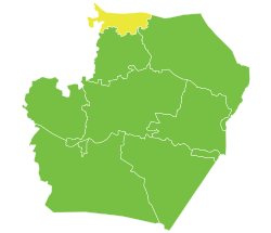
 Location of Tell Abyad District within Raqqa Governorate | |
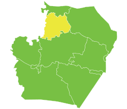
 Tell Abyad District Location in Syria | |
| Coordinates (Tell Abyad): 36.6975°N 38.9567°E | |
| Country | |
| Governorate | Raqqa |
| Seat | Tell Abyad |
| Subdistricts | 3 nawāḥī |
| Area | |
| • Total | 4,834.02 km2 (1,866.43 sq mi) |
| Population (2004)[1] | 129,714 |
| Geocode | SY1102 |
Demographics
At the 2004 census, the district had a population of 129,714.[1] The majority of inhabitants are Arabs,[3] with considerable Kurdish[4][5] and Turkmen minorities. All three groups are overwhelmingly Sunni. The western part of the district is mainly inhabited by Kurds, the Turkmens are mainly concentrated in Suluk and southwest of the town[6] and the rest of the district is almost all Arab.
Subdistricts
The district of Tell Abyad is divided into three subdistricts or nawāḥī (population as of 2004[1]):
- Tell Abyad Subdistrict (ناحية تل أبيض): population 44,671.[7]
- Suluk Subdistrict (ناحية سلوك): population 44,131[8]
- Ayn Issa Subdistrict (ناحية عين عيسى): population 40,912.[9]
Archaeology
In the valley of the Balikh River, there exists an archaeological site called Tell Sabi Abyad.[10]
References
- "General Census of Population and Housing 2004" (PDF) (in Arabic). Syrian Central Bureau of Statistics. Archived from the original (PDF) on 8 December 2015. Retrieved 15 October 2015. Also available in English: "2004 Census Data". UN OCHA. Retrieved 15 October 2015.
- "Turkey provokes our forces in Tel Abyad and Ras al-Ain: SDF". North Press Agency. 2021-11-10. Retrieved 2021-12-28.
{{cite web}}: CS1 maint: url-status (link) - "Arab Tribes Split Between Kurds And Jihadists". Carnegie Endowment for International Peace. 2015. Retrieved 26 June 2015.
- "Kurds eye new corridor to Mediterranean". Al-Monitor.
- "US Expresses Concerns About PYD Human Rights". BasNews. Retrieved 26 June 2015.
- "Pre civil war ethno-religious map of Ar Raqqah goverornate - uMap". umap.openstreetmap.fr. Retrieved 2017-06-14.
- "Tal Abyad nahiyah population". Cbssyr.org. Archived from the original on 2012-07-28. Retrieved 2012-07-05.
- "Suluk nahiyah population". Cbssyr.org. Archived from the original on 2012-07-28. Retrieved 2012-07-05.
- "Ayn Issa nahiyah population". Cbssyr.org. Archived from the original on 2012-07-28. Retrieved 2012-07-05.
- Akkermans, P. M. M. G.; Archeology, Faculty of (1989). "Excavations at Tell Sabi Abyad – Prehistoric Investigations in the Balikh Valley, Northern Syria". International Series 468, (1989). Retrieved 2020-08-04.
This article about a location in Raqqa Governorate, Syria is a stub. You can help Wikipedia by expanding it. |
На других языках
- [en] Tell Abyad District
[ru] Эт-Телль-эль-Абьяд (район)
Эт-Телль-эль-Абьяд (араб. تل أبيض) — район (минтака) в составе мухафазы Эр-Ракка, Сирия. Административным центром является город Эт-Телль-эль-Абьяд.Другой контент может иметь иную лицензию. Перед использованием материалов сайта WikiSort.org внимательно изучите правила лицензирования конкретных элементов наполнения сайта.
WikiSort.org - проект по пересортировке и дополнению контента Википедии