world.wikisort.org - Syria
Jarabulus District (Arabic: منطقة جرابلس, romanized: manṭiqat Ğarābulus) is a district of Aleppo Governorate in northern Syria, on the border with Turkey. The administrative centre is the city of Jarabulus.
Subdistricts of Jarabulus District

The administrative center of Jarabulus Subdistrict shown above is the city of Jarabulus.

The administrative center of Ghandoura Subdistrict shown above is the city of Ghandoura.
Jarabulus District
منطقة جرابلس | |
|---|---|
District | |
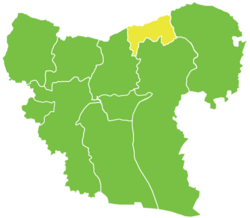 Location of Jarabulus District within Aleppo Governorate | |
 Jarabulus District Location in Syria | |
| Coordinates (Jarabulus): 36.82°N 38.02°E | |
| Country | |
| Governorate | Aleppo |
| Seat | Jarabulus |
| Control | |
| Subdistricts | 2 nawāḥī |
| Area | |
| • Total | 607.48 km2 (234.55 sq mi) |
| Population (2004)[1] | 58,889 |
| Geocode | SY0208 |
At the 2004 census, the district had a population of 58,889.[1] Ethnically, it is composed of Arabs, Turkmens and Kurds.[2][3][4] Many Kurds settled during the 17th century in the area.[5]
The Euphrates river enters Syria from Turkey in Jarabulus.
Subdistricts
The district of Jarabulus is divided into two subdistricts or nawāḥī (population as of 2004[1]):
| Code | Name | Area | Population | Seat |
|---|---|---|---|---|
| SY020800 | Jarabulus Subdistrict | 316.52 km² | 41,575 | Jarabulus |
| SY020801 | Ghandoura Subdistrict | 290.95 km² | 17,314 | Ghandoura |
References
- "General Census of Population and Housing 2004" (PDF) (in Arabic). Syrian Central Bureau of Statistics. Archived from the original (PDF) on 8 December 2015. Retrieved 15 October 2015. Also available in English: "2004 Census Data". UN OCHA. Retrieved 15 October 2015.
- van Wilgenburg, Wladimir. "Kurdish Strategy Towards Ethnically-Mixed Areas in the Syrian Conflict". Terrorism Monitor Volume: 11 Issue: 23. The Jamestown Foundation. Retrieved 27 December 2013.
- Khalifa, Mustafa. "The impossible partition of Syria" (PDF). Thematic Studies. Arab Reform Initiative. Archived from the original (PDF) on December 27, 2013. Retrieved 27 December 2013.
- SURİYE’DE GÜVENLİ BÖLGE TARTIŞMALARI: TÜRKİYE AÇISINDAN RİSKLER, FIRSATLAR VE SENARYOLAR (PDF) (in Turkish, English, and Arabic). ORTADOĞU STRATEJİK ARAŞTIRMALAR MERKEZİ. 2012. ISBN 978-605-4615-10-0. Archived from the original (PDF) on December 27, 2013. Retrieved 27 December 2013.
- Tejel, Jordi (2008). Syria's Kurds: History, Politics and Society. Routledge. p. 10. ISBN 978-1-134-09642-8.
Capital: Aleppo | ||||||||||||||||||||
|  | |||||||||||||||||||
|
| ||||||||||||||||||||
| ||||||||||||||||||||
| ||||||||||||||||||||
| ||||||||||||||||||||
| ||||||||||||||||||||
| ||||||||||||||||||||
| ||||||||||||||||||||
| ||||||||||||||||||||
This article about a location in Aleppo Governorate, Syria is a stub. You can help Wikipedia by expanding it. |
На других языках
- [en] Jarabulus District
[ru] Джерабулус (район)
Джераблу́с (араб. جرابلس) — район (араб. منطقة, минтака) в составе мухафазы Алеппо, Сирия. Его административным центром является город Джераблус. На 2004 год население района составляло 58 889 человек.Текст в блоке "Читать" взят с сайта "Википедия" и доступен по лицензии Creative Commons Attribution-ShareAlike; в отдельных случаях могут действовать дополнительные условия.
Другой контент может иметь иную лицензию. Перед использованием материалов сайта WikiSort.org внимательно изучите правила лицензирования конкретных элементов наполнения сайта.
Другой контент может иметь иную лицензию. Перед использованием материалов сайта WikiSort.org внимательно изучите правила лицензирования конкретных элементов наполнения сайта.
2019-2026
WikiSort.org - проект по пересортировке и дополнению контента Википедии
WikiSort.org - проект по пересортировке и дополнению контента Википедии