world.wikisort.org - Syria
Deir al-Adas (Arabic: دير العدس) is a village in southern Syria, administratively part of the Daraa Governorate. It is situated about 40 kilometers northwest of Daraa. According to the Central Bureau of Statistics (CBS), it had a population of 3,723.[1]
Deir al-Adas
دير العدس | |
|---|---|
Village | |
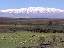
 Deir al-Adas with Mount Hermon in the background | |
 Deir al-Adas | |
| Coordinates: 33°9′38″N 36°7′28″E | |
| Grid position | 255/285 PAL |
| Country | |
| Governorate | Daraa Governorate |
| District | Al-Sanamayn District |
| Nahiyah | Ghabaghib |
| Elevation | 800 m (2,600 ft) |
| Population (2004 census) | |
| • Total | 3,273 |
| Time zone | UTC+2 (EET) |
| • Summer (DST) | UTC+3 (EEST) |
| Website | http://www.discover-syria.com/ |
The name means Monastery (deir) of the Lentils (al-'adas).
History
In 1838, Deir al-Adas was noted as a village in the el-Jeidur district.[2]
Syrian Civil War
On 10 June 2022, eleven farmworkers were killed after a landmine exploded underneath their car in the village.[3][4]
See also
- Hauran
References
- General Census of Population and Housing 2004. Syria Central Bureau of Statistics (CBS). Homs Governorate. (in Arabic)
- Robinson and Smith, 1841, vol 3, 2nd appendix, p. 149
- "Five civilians killed in mine explosion in Syria's Deraa". TheNationalNews.com. 10 June 2022.
- "Landmine explosion | 11 people, including five children under 18, killed north of Daraa". Syrian Observatory for Human Rights. 11 June 2022.
Bibliography
- Robinson, E.; Smith, E. (1841). Biblical Researches in Palestine, Mount Sinai and Arabia Petraea: A Journal of Travels in the year 1838. Vol. 3. Boston: Crocker & Brewster.
External links
- http://www.discover-syria.com
- Map of town, Google Maps
- Sanameine-map, 19L
Текст в блоке "Читать" взят с сайта "Википедия" и доступен по лицензии Creative Commons Attribution-ShareAlike; в отдельных случаях могут действовать дополнительные условия.
Другой контент может иметь иную лицензию. Перед использованием материалов сайта WikiSort.org внимательно изучите правила лицензирования конкретных элементов наполнения сайта.
Другой контент может иметь иную лицензию. Перед использованием материалов сайта WikiSort.org внимательно изучите правила лицензирования конкретных элементов наполнения сайта.
2019-2025
WikiSort.org - проект по пересортировке и дополнению контента Википедии
WikiSort.org - проект по пересортировке и дополнению контента Википедии