world.wikisort.org - Sweden
Timrå (![]() pronunciation) is a locality and the seat of Timrå Municipality in Västernorrland County, Sweden with 10,443 inhabitants in 2010.[1]
pronunciation) is a locality and the seat of Timrå Municipality in Västernorrland County, Sweden with 10,443 inhabitants in 2010.[1]
Timrå | |
|---|---|
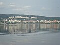
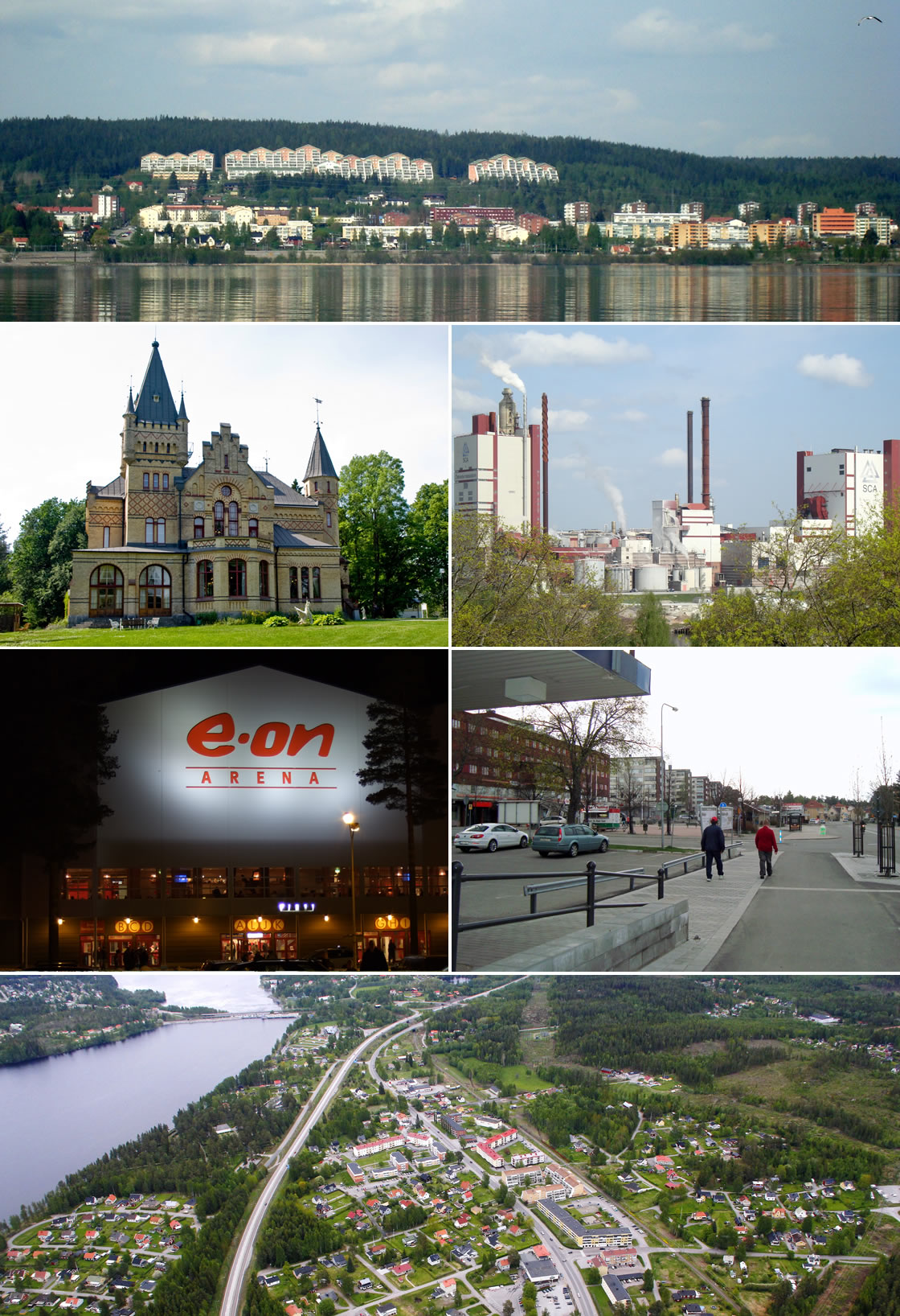 Timrå montage, Top:Panorama view of downtown Timrå, from Alnön area, 2nd left:A native house and museum in Merlo Slotto, 2nd right:A headquarters in Östrands pulp (Östrands massafabrik), 3rd left:Sydkraft Arena (E.ON Arena), 3rd right:Köpmansgatan Square, Bottom:Aerial view over Sörberge with Indalsälven left and Fairhaven in the upper right corner | |
 Timrå  Timrå | |
| Coordinates: 62°29′13″N 17°19′33″E | |
| Country | Sweden |
| Province | Medelpad |
| County | Västernorrland County |
| Municipality | Timrå Municipality |
| Area | |
| • City | 12.03 km2 (4.64 sq mi) |
| • Metro | 787.98 km2 (304.24 sq mi) |
| Elevation | 19 m (62 ft) |
| Population (31 December 2010)[1] | |
| • City | 10,443 |
| • Density | 868/km2 (2,250/sq mi) |
| • Metro | 17,844 |
| Time zone | UTC+1 (CET) |
| • Summer (DST) | UTC+2 (CEST) |
| Postal code | 860 xx |
| Area code(s) | (+46) 60 |
| Website | www |
It is located about 13 km north of Sundsvall (a town with a metropolitan area of some 100,000 inhabitants), and could arguably be considered a satellite to that town.
The two closest cities (Sundsvall and Härnösand) share one airport, Midlanda, that is geographically located in Timrå.
Indalsälven, one of Sweden's largest rivers with a length of 430 km, meets the Gulf of Botnia in Timrå.
In Sweden, Timrå is mainly known for its ice hockey club Timrå IK, which, as of season 2021/22 plays in the Swedish top division SHL.
In 1995, Swedish artist Bengt Lindström constructed the Y, a 30 meter high sculpture located in Timrå.
Local legend says that Sörberge, on the north side of the town, is haunted by a tall man wearing a very large coat called 'Stor Bubbas'.
Climate
Timrå has historically had a subarctic climate, but it has in recent decades more resembled a cool-summer humid continental climate.
| Climate data for Sundsvall Airport (2002–2021); extremes since 1943; sunshine[2] 1961–1990 | |||||||||||||
|---|---|---|---|---|---|---|---|---|---|---|---|---|---|
| Month | Jan | Feb | Mar | Apr | May | Jun | Jul | Aug | Sep | Oct | Nov | Dec | Year |
| Record high °C (°F) | 11.0 (51.8) |
13.8 (56.8) |
15.2 (59.4) |
21.9 (71.4) |
27.4 (81.3) |
35.0 (95.0) |
33.0 (91.4) |
31.3 (88.3) |
27.2 (81.0) |
21.5 (70.7) |
14.0 (57.2) |
10.5 (50.9) |
35.0 (95.0) |
| Mean maximum °C (°F) | 5.3 (41.5) |
6.8 (44.2) |
11.5 (52.7) |
16.8 (62.2) |
22.2 (72.0) |
25.7 (78.3) |
27.8 (82.0) |
26.0 (78.8) |
21.1 (70.0) |
14.5 (58.1) |
8.8 (47.8) |
6.7 (44.1) |
28.8 (83.8) |
| Average high °C (°F) | −2.5 (27.5) |
−1.2 (29.8) |
3.3 (37.9) |
8.6 (47.5) |
14.0 (57.2) |
18.8 (65.8) |
21.7 (71.1) |
20.0 (68.0) |
15.3 (59.5) |
8.3 (46.9) |
2.6 (36.7) |
−0.6 (30.9) |
9.0 (48.2) |
| Daily mean °C (°F) | −6.5 (20.3) |
−5.6 (21.9) |
−1.4 (29.5) |
3.5 (38.3) |
8.6 (47.5) |
13.5 (56.3) |
16.7 (62.1) |
15.6 (60.1) |
10.8 (51.4) |
4.6 (40.3) |
−0.4 (31.3) |
−4.1 (24.6) |
4.6 (40.3) |
| Average low °C (°F) | −10.4 (13.3) |
−10.0 (14.0) |
−6.1 (21.0) |
−1.7 (28.9) |
3.2 (37.8) |
8.2 (46.8) |
11.7 (53.1) |
10.6 (51.1) |
6.2 (43.2) |
0.8 (33.4) |
−3.4 (25.9) |
−7.6 (18.3) |
0.1 (32.2) |
| Mean minimum °C (°F) | −22.5 (−8.5) |
−21.5 (−6.7) |
−17.4 (0.7) |
−7.4 (18.7) |
−3.0 (26.6) |
2.3 (36.1) |
6.1 (43.0) |
4.5 (40.1) |
−0.1 (31.8) |
−6.4 (20.5) |
−11.5 (11.3) |
−16.8 (1.8) |
−24.9 (−12.8) |
| Record low °C (°F) | −35.5 (−31.9) |
−34.8 (−30.6) |
−34.2 (−29.6) |
−20.0 (−4.0) |
−8.2 (17.2) |
−2.0 (28.4) |
1.9 (35.4) |
−0.6 (30.9) |
−7.7 (18.1) |
−15.2 (4.6) |
−22.1 (−7.8) |
−36.6 (−33.9) |
−36.6 (−33.9) |
| Average precipitation mm (inches) | 56.1 (2.21) |
31.7 (1.25) |
30.5 (1.20) |
27.6 (1.09) |
43.3 (1.70) |
46.9 (1.85) |
58.8 (2.31) |
72.5 (2.85) |
59.6 (2.35) |
63.6 (2.50) |
51.0 (2.01) |
59.1 (2.33) |
600.7 (23.65) |
| Average extreme snow depth cm (inches) | 38 (15) |
45 (18) |
43 (17) |
23 (9.1) |
0 (0) |
0 (0) |
0 (0) |
0 (0) |
0 (0) |
0 (0) |
9 (3.5) |
22 (8.7) |
52 (20) |
| Mean monthly sunshine hours | 43 | 81 | 135 | 185 | 259 | 287 | 267 | 215 | 142 | 98 | 57 | 34 | 1,803 |
| Source 1: SMHI Open Data for Sundsvall-Timrå flygplats, temperature[3] | |||||||||||||
| Source 2: SMHI Open Data for Stordala-Midlanda D, precipitation[4] | |||||||||||||
Notable citizens
- Lennart "Lillstrimma" Svedberg (1944–1972), ice hockey player
- Magdalena Forsberg (1967), cross country skier, biathlon
- Henrik Flyman, guitarist, composer, producer
- Henrik Forsberg (1967), cross country skier
- Mats Näslund (1959), ice hockey player
- Anna Olsson (1964), canoeist
- Anton Lander (1991), ice hockey player
Gallery
 Timrå
Timrå The municipal office
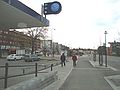 Town centre
 Östrand pulp mill


References
- "Tätorternas landareal, folkmängd och invånare per km2 2005 och 2010" (in Swedish). Statistics Sweden. 14 December 2011. Archived from the original on 27 January 2012. Retrieved 10 January 2012.
- "NOAA WMO Normals 1691–1990". National Oceanic & Atmospheric Administration.
- "SMHI Open Data for Sundsvall-Timrå flygplats, temperature" (in Swedish). Swedish Meteorological and Hydrological Institute. Retrieved 10 May 2022.
- "SMHI Open Data for Stordala-Midlanda D, precipitation" (in Swedish). SMHI. Retrieved 10 May 2022.
External links
Municipalities and seats of Västernorrland County | ||
|---|---|---|
| Municipalities | ||
| Municipal seats | ||
| ||
This article about a location in Västernorrland County, Sweden is a stub. You can help Wikipedia by expanding it. |
На других языках
- [en] Timrå
[ru] Тимро
Тимро (на шведском языке Timrå) — город в восточной части Швеции, в лене Вестерноррланд, административный центр одноименной коммуны. Расположен около устья одной из крупнейших рек Швеции (длиной 430 км) Индальсэльвен на побережье Ботнического залива. Находится примерно в 340 км на северо-восток от столицы страны, города Стокгольм и в 15 км к северу от крупнейшего города лена Вестерноррланд, города Сундсвалль. В 1947 г. получил статус торгового города.Другой контент может иметь иную лицензию. Перед использованием материалов сайта WikiSort.org внимательно изучите правила лицензирования конкретных элементов наполнения сайта.
WikiSort.org - проект по пересортировке и дополнению контента Википедии