world.wikisort.org - Sweden
Oxelösund is a locality and the seat of Oxelösund Municipality in Södermanland County, Sweden with 11,488 inhabitants in 2018.[2] It is located less than 15 kilometres (9.3 mi) south from the city centre of its larger neighbour Nyköping, with the two urban areas forming a wider agglomeration of nearly 50,000 people.
Oxelösund | |
|---|---|
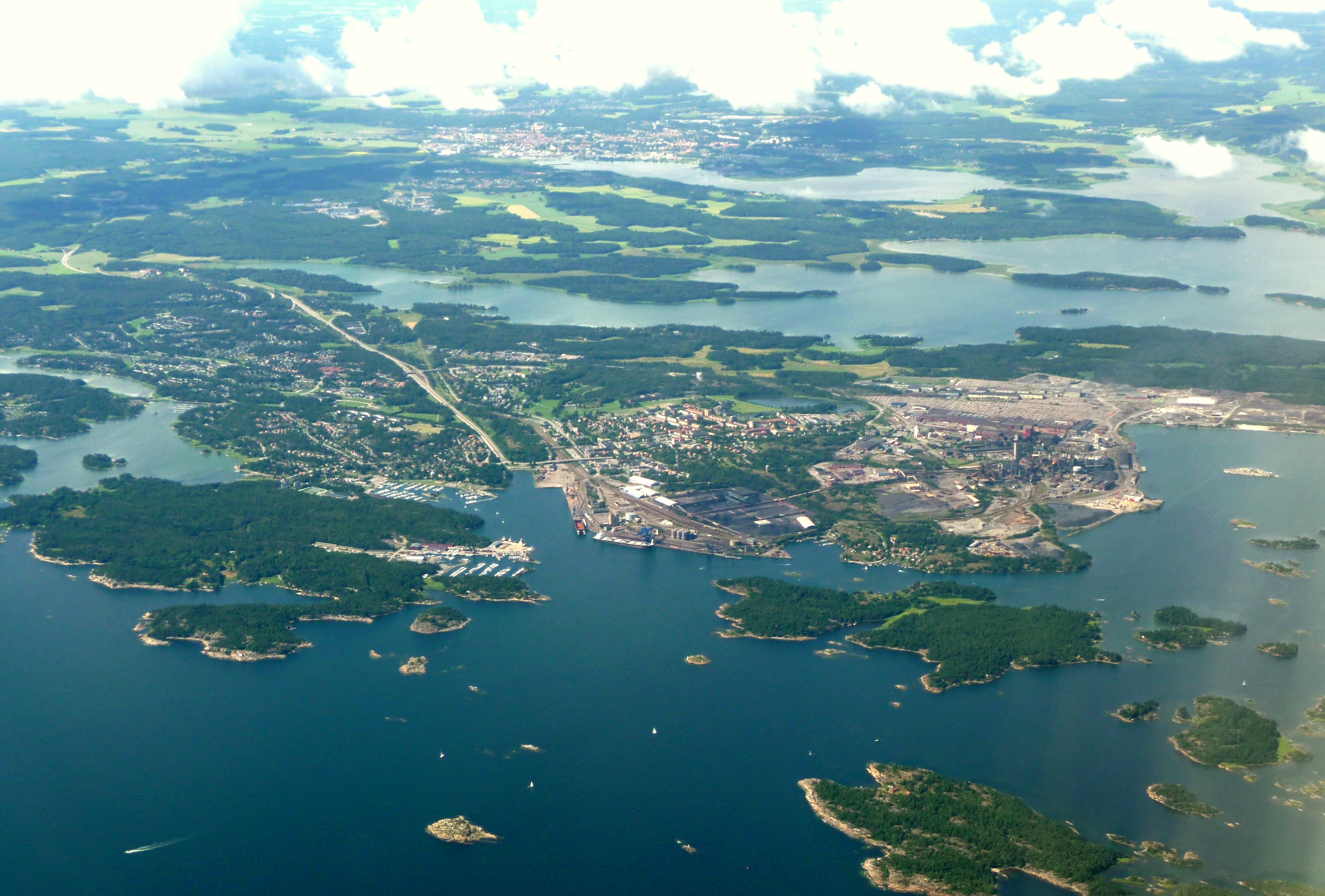 2012 aerial view of Oxelösund with Nyköping in the background | |
 Oxelösund  Oxelösund | |
| Coordinates: 58°40′N 17°07′E | |
| Country | Sweden |
| Province | Södermanland |
| County | Södermanland County |
| Municipality | Oxelösund Municipality |
| Area | |
| • Total | 11.57 km2 (4.47 sq mi) |
| Population (2018)[2] | |
| • Total | 11,488 |
| • Density | 1,019/km2 (2,640/sq mi) |
| Time zone | UTC+1 (CET) |
| • Summer (DST) | UTC+2 (CEST) |
History
The harbour at Oxelösund has been used for at least 500 years. In the 19th century, an increased extraction from the mining district of Central Sweden (e.g. Bergslagen), made Oxelösund a harbour of transport. A local railroad company was established in 1873, and bought virtually the entire peninsula which at the time belonged to the estates of the Stjärnholm Castle.
An iron works was constructed in 1913, and the community Oxelösund expanded, with the harbour, rail road and iron works being its cornerstones.
In 1950, the city was sufficiently developed to get the title of a city and was one of the last towns to receive city status in Sweden. Since 1971 this status is obsolete, but Oxelösund is the seat of a municipality with the same territory, one of the smallest in the country.
In November 2011, Oxelösund hosted the Nordic Under-21 Championships in underwater rugby.
Femöre battery is located near the area.
Companies
- SSAB, Swedish steel.
Climate
Oxelösund has a hybrid between a maritime and humid continental climate, with moderated patterns which stem from its position at the head of a peninsula, with the weather station facing the open sea. In much of the urban area and up the peninsula the climate is somewhat more prone to swings, something intensifying farther north as in Nyköping.
| Climate data for Oxelösund (Femöre) 2002–2021; extremes since 1961 | |||||||||||||
|---|---|---|---|---|---|---|---|---|---|---|---|---|---|
| Month | Jan | Feb | Mar | Apr | May | Jun | Jul | Aug | Sep | Oct | Nov | Dec | Year |
| Record high °C (°F) | 12.1 (53.8) |
14.6 (58.3) |
19.4 (66.9) |
23.1 (73.6) |
28.2 (82.8) |
31.3 (88.3) |
31.5 (88.7) |
35.0 (95.0) |
25.0 (77.0) |
20.6 (69.1) |
14.7 (58.5) |
13.3 (55.9) |
35.0 (95.0) |
| Mean maximum °C (°F) | 7.5 (45.5) |
7.9 (46.2) |
13.5 (56.3) |
17.7 (63.9) |
22.7 (72.9) |
26.4 (79.5) |
28.2 (82.8) |
26.5 (79.7) |
22.4 (72.3) |
16.3 (61.3) |
11.7 (53.1) |
8.2 (46.8) |
28.9 (84.0) |
| Average high °C (°F) | 1.6 (34.9) |
2.0 (35.6) |
5.6 (42.1) |
10.5 (50.9) |
15.2 (59.4) |
19.9 (67.8) |
22.6 (72.7) |
21.5 (70.7) |
17.3 (63.1) |
11.0 (51.8) |
6.4 (43.5) |
3.4 (38.1) |
11.4 (52.6) |
| Daily mean °C (°F) | −0.7 (30.7) |
−0.6 (30.9) |
2.3 (36.1) |
6.5 (43.7) |
11.2 (52.2) |
16.0 (60.8) |
18.8 (65.8) |
17.9 (64.2) |
13.8 (56.8) |
8.3 (46.9) |
4.3 (39.7) |
1.3 (34.3) |
8.3 (46.8) |
| Average low °C (°F) | −2.9 (26.8) |
−3.1 (26.4) |
−1.1 (30.0) |
2.4 (36.3) |
7.2 (45.0) |
12.0 (53.6) |
14.9 (58.8) |
14.2 (57.6) |
10.3 (50.5) |
5.5 (41.9) |
2.1 (35.8) |
−0.8 (30.6) |
5.1 (41.1) |
| Mean minimum °C (°F) | −12.3 (9.9) |
−12.0 (10.4) |
−7.9 (17.8) |
−2.4 (27.7) |
1.9 (35.4) |
6.9 (44.4) |
10.9 (51.6) |
9.0 (48.2) |
4.2 (39.6) |
−1.7 (28.9) |
−5.3 (22.5) |
−8.9 (16.0) |
−14.9 (5.2) |
| Record low °C (°F) | −25.1 (−13.2) |
−27.1 (−16.8) |
−18.8 (−1.8) |
−9.0 (15.8) |
−4.7 (23.5) |
−0.2 (31.6) |
4.9 (40.8) |
5.2 (41.4) |
−0.9 (30.4) |
−6.9 (19.6) |
−14.7 (5.5) |
−20.8 (−5.4) |
−27.1 (−16.8) |
| Average precipitation mm (inches) | 37.0 (1.46) |
27.2 (1.07) |
27.1 (1.07) |
23.3 (0.92) |
41.8 (1.65) |
55.4 (2.18) |
55.6 (2.19) |
71.0 (2.80) |
39.8 (1.57) |
56.6 (2.23) |
49.7 (1.96) |
45.3 (1.78) |
529.8 (20.88) |
| Source 1: SMHI[3] | |||||||||||||
| Source 2: SMHI Open Data[4] | |||||||||||||
References
- "Tätorternas landareal, folkmängd och invånare per km2 2005 och 2010" (in Swedish). Statistics Sweden. 14 December 2011. Archived from the original on 27 January 2012. Retrieved 10 January 2012.
- "Statistiska tätorter 2018, befolkning, landareal, befolkningstäthet per tätort" (in Swedish). Statistics Sweden. 24 October 2019.
- "SMHI Öppna Data" (in Swedish). Swedish Metereological and Hydrological Institut.
- "SMHI Öppna Data" (in Swedish). SMHI. 3 January 2022.
External links
 Oxelösund travel guide from Wikivoyage
European Union: Members of the town twinning "Douzelage" | ||
|---|---|---|
| Current members | ||
| Former members |
| |
Authority control | |
|---|---|
| General | |
| National libraries | |
| Other |
|
This article about a location in Södermanland County, Sweden is a stub. You can help Wikipedia by expanding it. |
На других языках
[de] Oxelösund
Oxelösund ist eine Ortschaft (tätort) in der schwedischen Provinz Södermanlands län und Hauptort der Gemeinde gleichen Namens. Sie liegt 10 km südöstlich von Nyköping und ist mit ihr durch den 1965 erbauten riksväg 53 verbunden. Sowohl Nyköping als auch Oxelösund verfügen über Häfen an der Ostsee.- [en] Oxelösund
[ru] Укселёсунд
Укселёсу́нд[1][2][3], ранее — Окселёсу́нд[4][5][6](швед. Oxelösund) — город в лене Сёдерманланд в Швеции, центр одноимённой коммуны. Расположен на небольшом полуострове, вдающемся в Балтийское море, в 15 километрах к юго-востоку от центра лена Нючёпинга. Издавна известен как порт. В 2011 году население города насчитывало 10870 жителей[7].Другой контент может иметь иную лицензию. Перед использованием материалов сайта WikiSort.org внимательно изучите правила лицензирования конкретных элементов наполнения сайта.
WikiSort.org - проект по пересортировке и дополнению контента Википедии