world.wikisort.org - Sweden
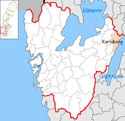
Karlsborg Municipality (Karlsborgs kommun) is a municipality in Västra Götaland County in western Sweden. Its seat is located in the town of Karlsborg.
Karlsborg Municipality
Karlsborgs kommun | |
|---|---|
Municipality | |
 Karlsborg town hall | |
 Coat of arms | |
 | |
| Coordinates: 58°32′N 14°31′E | |
| Country | Sweden |
| County | Västra Götaland County |
| Seat | Karlsborg |
| Area | |
| • Total | 797.35 km2 (307.86 sq mi) |
| • Land | 405.87 km2 (156.71 sq mi) |
| • Water | 391.48 km2 (151.15 sq mi) |
| Area as of 1 January 2014. | |
| Population (31 December 2021)[2] | |
| • Total | 6,965 |
| • Density | 8.7/km2 (23/sq mi) |
| Time zone | UTC+1 (CET) |
| • Summer (DST) | UTC+2 (CEST) |
| ISO 3166 code | SE |
| Province | Västergötland |
| Municipal code | 1446 |
| Website | www.karlsborg.se |
The present municipality was formed in 1971 when "old" Karlsborg was amalgamated with Mölltorp and Undenäs.
The area has been dominated by Karlsborg Fortress and military activity throughout the last centuries.
Tiveden National Park is partly situated within the municipality. The Flugebyn airfield, home of the Västergötland Skydiving Club (Västergötlands Fallskärmsklubb) also lies in the municipality.
References
- "Statistiska centralbyrån, Kommunarealer den 1 januari 2014" (in Swedish). Statistics Sweden. 2014-01-01. Archived from the original (Microsoft Excel) on 2016-09-27. Retrieved 2014-04-18.
- "Folkmängd i riket, län och kommuner 31 december 2021" (in Swedish). Statistics Sweden. February 22, 2022. Retrieved February 22, 2022.
External links
 Media related to Karlsborg Municipality at Wikimedia Commons
- Karlsborg Municipality - Official site
Places adjacent to Karlsborg Municipality | |
|---|---|
Municipalities and seats of Västra Götaland County | ||
|---|---|---|
| Municipalities |
| |
| Municipal seats |
| |
| ||
На других языках
[de] Karlsborg (Gemeinde)
58.531914.5083 Karlsborg ist eine Gemeinde (schwedisch kommun) in der schwedischen Provinz Västra Götalands län sowie der historischen Provinz Västergötland und liegt am Westufer des Vättern. Hauptort ist der Ort Karlsborg. Weitere Ortschaften sind Forsvik, Mölltorp, Undenäs sowie weitere kleinere Dörfer.- [en] Karlsborg Municipality
Текст в блоке "Читать" взят с сайта "Википедия" и доступен по лицензии Creative Commons Attribution-ShareAlike; в отдельных случаях могут действовать дополнительные условия.
Другой контент может иметь иную лицензию. Перед использованием материалов сайта WikiSort.org внимательно изучите правила лицензирования конкретных элементов наполнения сайта.
Другой контент может иметь иную лицензию. Перед использованием материалов сайта WikiSort.org внимательно изучите правила лицензирования конкретных элементов наполнения сайта.
2019-2026
WikiSort.org - проект по пересортировке и дополнению контента Википедии
WikiSort.org - проект по пересортировке и дополнению контента Википедии