world.wikisort.org - Spain
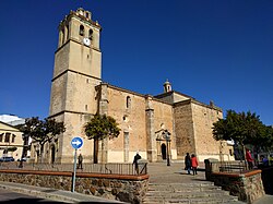
Montijo (Spanish pronunciation: [monˈtixo]) is a town and municipality in the province of Badajoz, in Extremadura, Spain. It has a population of 16,236 inhabitants (in 2010). It is located between Badajoz and Mérida, near Guadiana river banks. The extension of the municipality covers 3 different centers of population: Lácara, Barbaño and Montijo, the last one being the capital.
Montijo | |
|---|---|
City | |
 Spain Square | |
 Coat of arms | |
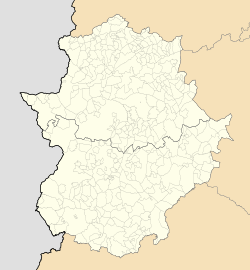
 Location in Badajoz | |
 Montijo Location of Montijo within Extremadura | |
| Coordinates: 38°54′36″N 6°37′3″W | |
| Country | |
| Autonomous Community | |
| Province | Badajoz |
| Comarca | Tierra de Mérida |
| Founded | Prerromanic |
| Government | |
| • Mayor | Manuel Gómez Rodríguez (PSOE) |
| Area | |
| • Total | 119.7 km2 (46.2 sq mi) |
| Elevation (AMSL) | 201 m (659 ft) |
| Population (2018)[1] | |
| • Total | 15,614 |
| • Density | 130/km2 (340/sq mi) |
| Time zone | UTC+1 (CET) |
| • Summer (DST) | UTC+2 (CEST (GMT +2)) |
| Postal code | 06480 |
| Area code(s) | +34 (Spain) + 924 (Badajoz) |
| Website | Official website |
The Battle of Montijo was fought near the town in 1644.
The town is also related to Eugenie de Montijo.
References
- Municipal Register of Spain 2018. National Statistics Institute.
На других языках
[de] Montijo (Badajoz)
Montijo ist eine Gemeinde (municipio) mit 15.457 Einwohnern (Stand: 2019) in der spanischen Provinz Badajoz in der Autonomen Gemeinschaft Extremadura. Sie liegt zwischen Badajoz und Mérida, in der Nähe der Ufer des Flusses Guadiana. Die Ausdehnung der Gemeinde umfasst 3 verschiedene Siedlungen: Lácara, Barbaño und Montijo, wobei die letztere der Gemeindesitz ist.- [en] Montijo, Spain
[es] Montijo (España)
Montijo es un municipio y pueblo español de la provincia de Badajoz, en la comunidad autónoma de Extremadura. En la actualidad cuenta con 15483 habitantes.[ru] Монтихо
Монтихо (исп. Montijo, эстр. Montiju) — город и муниципалитет в Испании, входит в провинцию Бадахос в составе автономного сообщества Эстремадура. Муниципалитет находится в составе района (комарки) Мерида. Занимает площадь 120 км². Население — 16 279 человек (на 2010 год). Расстояние до административного центра провинции — 42 км.Текст в блоке "Читать" взят с сайта "Википедия" и доступен по лицензии Creative Commons Attribution-ShareAlike; в отдельных случаях могут действовать дополнительные условия.
Другой контент может иметь иную лицензию. Перед использованием материалов сайта WikiSort.org внимательно изучите правила лицензирования конкретных элементов наполнения сайта.
Другой контент может иметь иную лицензию. Перед использованием материалов сайта WikiSort.org внимательно изучите правила лицензирования конкретных элементов наполнения сайта.
2019-2025
WikiSort.org - проект по пересортировке и дополнению контента Википедии
WikiSort.org - проект по пересортировке и дополнению контента Википедии