world.wikisort.org - Spain
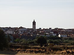
Lagartera is a municipality of Spain located in the province of Toledo, Castilla–La Mancha.[2] The municipality spans across a total area of 81.02 km2 and, as of 1 January 2020, it has a registered population of 1,354.[2]
Lagartera | |
|---|---|
Municipality | |
 | |
 Flag  Seal | |
 Lagartera  Lagartera | |
| Coordinates: 39°54′18″N 5°12′03″W | |
| Country | Spain |
| Autonomous community | Castilla–La Mancha |
| Province | Toledo |
| Area | |
| • Total | 81.02 km2 (31.28 sq mi) |
| Elevation | 389 m (1,276 ft) |
| Population (2018)[1] | |
| • Total | 1,405 |
| • Density | 17/km2 (45/sq mi) |
| Time zone | UTC+1 (CET) |
| • Summer (DST) | UTC+2 (CEST) |
History
Part of the Campo Arañuelo,[3] the settlement dates at least from the late 13th century.[4] The hamlet of Lagartera belonged to the lordship of Oropesa, which segregated from the land of Ávila in the late 13th century.[5] Lagartera was granted township on 21 January 1642.[6] The village of Lagartera is renowned for its centuries-old tradition of embroidery, needlework and lace-making.[7]
- Moza lagarterana by Jules Gervais-Courtellemont (1924)
References
- Citations
- Municipal Register of Spain 2018. National Statistics Institute.
- "Datos del Registro de Entidades Locales". Ministerio de Asuntos Económicos y Transformación Digital. Retrieved 5 August 2021.
- Fernández González 1993, p. 9.
- Luis López 2002, p. 33.
- Luis López 2002, pp. 43–44.
- Fernández González 1993, p. 10.
- "Lagartera, Toledo | TCLM". Archived from the original on 2008-12-02. Retrieved 2009-08-14.
- Bibliography
- Fernández González, M.ª Guadalupe (1993). El traje típico de Lagartera (PDF). Temas Toledanos. Toledo: Instituto Provincial de Investigaciones y Estudios Toledanos. ISBN 84-87103-39-1.
- Luis López, Carmelo (2002). "Las comarcas meridionales de la Tierra abulense medieval: precisiones a una problemática delimitación y repoblación". Studia Historica. Historia Medieval. Salamanca: Ediciones Universidad de Salamanca. 20. ISSN 0213-2052.
На других языках
- [en] Lagartera
[es] Lagartera
Lagartera es un municipio y localidad española de la provincia de Toledo, en la comunidad autónoma de Castilla-La Mancha. El término Lagartera se deriva del latín lacertus, lagarto, con el sufijo -aria, indicativo de abundancia.[1][ru] Лагартера
Лагартера (исп. Lagartera) — город и муниципалитет в Испании, входит в провинцию Толедо, в составе автономного сообщества Кастилия — Ла-Манча. Муниципалитет находится в составе района (комарки) Ла-Кампана-де-Олопеса. Занимает площадь 81 км². Население — 1595 человек (на 2010 год). Расстояние до административного центра провинции — 110 км.Текст в блоке "Читать" взят с сайта "Википедия" и доступен по лицензии Creative Commons Attribution-ShareAlike; в отдельных случаях могут действовать дополнительные условия.
Другой контент может иметь иную лицензию. Перед использованием материалов сайта WikiSort.org внимательно изучите правила лицензирования конкретных элементов наполнения сайта.
Другой контент может иметь иную лицензию. Перед использованием материалов сайта WikiSort.org внимательно изучите правила лицензирования конкретных элементов наполнения сайта.
2019-2025
WikiSort.org - проект по пересортировке и дополнению контента Википедии
WikiSort.org - проект по пересортировке и дополнению контента Википедии
