world.wikisort.org - Spain
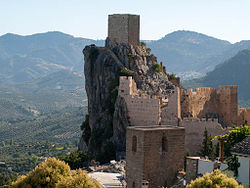
La Iruela is a town located in the province of Jaén, Andalusia, Spain. It sits on a peak of the Sierra de Cazorla and is home to the ruins of an 11th-century Moorish, and later Templar,[2] fortress which towers over the road from Cazorla to the Sierras de Cazorla, Segura y Las Villas Natural Park.[3] According to the 2005 census (INE), the city has a population of 1894 inhabitants.
La Iruela, Spain | |
|---|---|
town | |
 | |
 Seal | |
 La Iruela Location in the Province of Jaén  La Iruela La Iruela (Andalusia)  La Iruela La Iruela (Spain) | |
| Coordinates: 37°55′N 3°00′W | |
| Country | |
| Autonomous community | |
| Province | |
| Municipality | La Iruela |
| Area | |
| • Total | 124 km2 (48 sq mi) |
| Elevation | 954 m (3,130 ft) |
| Population (2018)[1] | |
| • Total | 1,935 |
| • Density | 16/km2 (40/sq mi) |
| Time zone | UTC+1 (CET) |
| • Summer (DST) | UTC+2 (CEST) |
| Website | http://www.lairuela.com/ |
References
- Municipal Register of Spain 2018. National Statistics Institute.
- Templespaña (2012). Gran Guía de la España Templaria. Aguilar. ISBN 978-8403098114.
- Ruiz, Ana (2007). Vibrant Andalusia: The Spice of Life in Southern Spain. Algora Publishing. p. 134. ISBN 978-0875865409.
Wikimedia Commons has media related to La Iruela.
На других языках
[de] La Iruela
La Iruela ist ein kleines Bergstädtchen und eine aus dem Hauptort, zwei Dörfern (Burunchel und Arroyo Frío) sowie mehreren Weilern (aldeas) und Einzelgehöften bestehende Gemeinde (municipio) mit insgesamt 1.899 Einwohnern (Stand: 1. Januar 2019) im Süden der Provinz Jaén in der autonomen Region Andalusien. Der Ort ist als Conjunto histórico-artístico anerkannt.- [en] La Iruela
[es] La Iruela
La Iruela es un municipio y localidad española del este de la provincia de Jaén, en Andalucía. Se encuentra en las faldas de la sierra de Cazorla, coronando el valle del Guadalquivir.[ru] Ла-Ируэла
Ла-Ируэла (исп. La Iruela) — муниципалитет в Испании, входит в провинцию Хаэн, в составе автономного сообщества Андалусия. Муниципалитет находится в составе района (комарки) Сьерра-де-Касорла. Занимает площадь 124 км². Население — 2011 человек (на 2010 год). Расстояние — 1 км до административного центра провинции.Текст в блоке "Читать" взят с сайта "Википедия" и доступен по лицензии Creative Commons Attribution-ShareAlike; в отдельных случаях могут действовать дополнительные условия.
Другой контент может иметь иную лицензию. Перед использованием материалов сайта WikiSort.org внимательно изучите правила лицензирования конкретных элементов наполнения сайта.
Другой контент может иметь иную лицензию. Перед использованием материалов сайта WikiSort.org внимательно изучите правила лицензирования конкретных элементов наполнения сайта.
2019-2025
WikiSort.org - проект по пересортировке и дополнению контента Википедии
WikiSort.org - проект по пересортировке и дополнению контента Википедии