world.wikisort.org - Spain
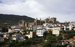
Guadalupe is a municipality of Spain located in the province of Cáceres, Extremadura.[2] It has a total area of 68.19km2 and, as of 1 January 2021, a registered population of 1,822.[2] The monastery of Santa María de Guadalupe is situated here.
This article may be expanded with text translated from the corresponding article in Spanish. (June 2020) Click [show] for important translation instructions.
|
Guadalupe | |
|---|---|
Municipality | |
 | |
 Flag  Seal | |
 Guadalupe Location within mainland Spain | |
| Coordinates: 39°27′10″N 5°19′39″W | |
| Country | Spain |
| Autonomous community | Extremadura |
| Province | Cáceres |
| Area | |
| • Total | 68.19 km2 (26.33 sq mi) |
| Elevation | 640 m (2,100 ft) |
| Population (2018)[1] | |
| • Total | 1,887 |
| • Density | 28/km2 (72/sq mi) |
| Time zone | UTC+1 (CET) |
| • Summer (DST) | UTC+2 (CEST) |
 | |
Geography
The Guadalupe River has its origins near the town in the Sierra de las Villuercas. Its highest point, the Pico la Villuerca reaches an altitude of 1603 m.[3]
See also
- Monastery of Santa María de Guadalupe
References
- Municipal Register of Spain 2018. National Statistics Institute.
- "Datos del Registro de Entidades Locales". Ministerio de Asuntos Económicos y Transformación Digital. Retrieved 23 May 2022.
- Pico la Villuerca Archived 2013-12-16 at the Wayback Machine
| Wikimedia Commons has media related to Guadalupe. |
На других языках
[de] Guadalupe (Spanien)
Guadalupe ist ein Ort und eine Gemeinde (municipio) mit etwa 1800 Einwohnern in der Provinz Cáceres in der Autonomen Region Extremadura in Spanien. Der Ort ist weit über Spanien hinaus berühmt wegen seiner Wallfahrtskirche und seines Klosters (Real Monasterio de Nuestra Señora de Guadalupe), das im Jahr 1993 in die Liste des Weltkulturerbes der UNESCO aufgenommen wurde.- [en] Guadalupe, Cáceres
[es] Guadalupe (España)
La Puebla de Guadalupe, o Guadalupe, es un municipio y localidad española de la provincia de Cáceres, en la comunidad autónoma de Extremadura. Se sitúa en la mancomunidad de Villuercas-Ibores-Jara y en el partido judicial de Logrosán. Los pueblos más cercanos por carretera son Cañamero, Alía, Castilblanco, Logrosán y Navalvillar de Ibor. El municipio tiene 1822 habitantes según el último dato del INE de 2018.[ru] Гуадалупе (Касерес)
Гуадалупе (исп. Guadalupe) — муниципалитет в Испании, входит в провинцию Касерес в составе автономного сообщества Эстремадура. Муниципалитет находится в составе района (комарки) Лас-Вильуэркас. Занимает площадь 68,2 км². Население — 2090 человек (на 2010 год). Расстояние до административного центра провинции — 135 км. Главная достопримечательность — замок-монастырь Гвадалупе.Текст в блоке "Читать" взят с сайта "Википедия" и доступен по лицензии Creative Commons Attribution-ShareAlike; в отдельных случаях могут действовать дополнительные условия.
Другой контент может иметь иную лицензию. Перед использованием материалов сайта WikiSort.org внимательно изучите правила лицензирования конкретных элементов наполнения сайта.
Другой контент может иметь иную лицензию. Перед использованием материалов сайта WikiSort.org внимательно изучите правила лицензирования конкретных элементов наполнения сайта.
2019-2025
WikiSort.org - проект по пересортировке и дополнению контента Википедии
WikiSort.org - проект по пересортировке и дополнению контента Википедии