world.wikisort.org - South_Korea
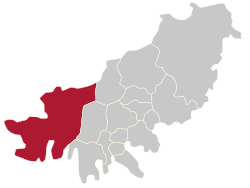
Gangseo District (literally west of river district) is a gu on the west side of Nakdong River in Busan, South Korea. It has an area of 179.05 km², and a population of about 66,000; it has a lower population density than Gijang county of Busan. Gangseo-gu was part of Buk-gu from its creation in 1978 to 1989 when it became an independent gu.
Gangseo
강서구 | |
|---|---|
Autonomous District | |
| Korean transcription(s) | |
| • Hanja | 江西區 |
| • Revised Romanization | Gangseo-gu |
| • McCune-Reischauer | Kangsǒ-ku |
 | |
 Flag | |
 | |
| Country | South Korea |
| Region | Yeongnam |
| Provincial level | Busan |
| Administrative divisions | 8 administrative dong |
| Area | |
| • Total | 179.05 km2 (69.13 sq mi) |
| Population (2015 May 31[1]) | |
| • Total | 84,558 |
| • Density | 470/km2 (1,200/sq mi) |
| • Dialect | Gyeongsang |
| Website | Gangseo District Office |

Gangseo-gu is the westernmost gu in Busan and it shares a common borders with Gimhae on its north-west side and Jinhae-gu, Changwon on its south-west side.
Gangseo-gu is the birthplace of the Gaya civilization.
Gimhae International Airport, Heungguk Temple, Myeongwol Temple, as well as the Eulsukdo bird sanctuary are located in Gangseo-gu.
Administrative divisions

Gangseo-gu is divided into 22 legal dong. They have been grouped together to form only 7 administrative dong, as follows:
- Daejeo 1-dong
- Daejeo 2-dong
- Gangdong-dong
- Myeongji 1-dong
- Myeongji 2-dong
- Garak-dong (4 legal dong)
- Jukrim-dong, Sikman-dong, Jukdong-dong, Bongnim-dong
- Noksan-dong (9 legal dong)
- Songjeong-dong, Hwajeon-dong, Noksan-dong, Saenggok-dong, Gurang-dong, Jisa-dong, Mieum-dong, Beombang-dong, Sinho-dong
- Gadeokdo-dong (5 legal dong)
- Dongseon-dong, Seongbuk-dong, Nulcha-dong, Cheonseong-dong, Daehang-dong
See also
- Geography of South Korea
References
- ":: Gangseo District ::". Archived from the original on 2007-09-28.
External links
| Wikimedia Commons has media related to Gangseo-gu, Busan. |
- Gangseo-gu website (in English)
Authority control | |
|---|---|
| General | |
| National libraries | |
This South Korea location article is a stub. You can help Wikipedia by expanding it. |
Другой контент может иметь иную лицензию. Перед использованием материалов сайта WikiSort.org внимательно изучите правила лицензирования конкретных элементов наполнения сайта.
WikiSort.org - проект по пересортировке и дополнению контента Википедии