world.wikisort.org - South_Africa
Patensie is a town in Sarah Baartman District Municipality in the Eastern Cape province of South Africa. Patensie lies along the R331 road just south of Noorshoek. The Kouga Dam is located several kilometres to the west. The name is Khoi in origin, and means "cattle resting place".[3] The town is a centre for the citrus, tobacco, and vegetable farms in the area.[3]
Patensie | |
|---|---|
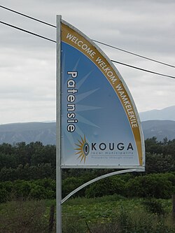
 Signboard on the R331 outside Patensie | |
 Patensie  Patensie | |
| Coordinates: 33°45′32″S 24°48′53″E | |
| Country | South Africa |
| Province | Eastern Cape |
| District | Sarah Baartman |
| Municipality | Kouga |
| Established | 1858 [1] |
| Area | |
| • Total | 6.23 km2 (2.41 sq mi) |
| Population (2011)[2] | |
| • Total | 5,263 |
| • Density | 840/km2 (2,200/sq mi) |
| Racial makeup (2011) | |
| • Black African | 39.7% |
| • Coloured | 50.2% |
| • Indian/Asian | 0.2% |
| • White | 8.0% |
| • Other | 1.9% |
| First languages (2011) | |
| • Afrikaans | 70.0% |
| • Xhosa | 24.9% |
| • English | 1.4% |
| • Other | 3.7% |
| Time zone | UTC+2 (SAST) |
| Postal code (street) | 6335 |
| PO box | 6335 |
| Area code | 042 |
| Website | www.patensie-is-lekker.co.za |
References
- "Patensie". Gamtoos Tourism. Retrieved 25 February 2012.
- "Main Place Patensie". Census 2011.
- "Cacadu Region". Revealed.co.za. Archived from the original on 3 September 2014. Retrieved 28 August 2014.
External links
Wikivoyage has a travel guide for Patensie.
Wikimedia Commons has media related to Patensie.
Текст в блоке "Читать" взят с сайта "Википедия" и доступен по лицензии Creative Commons Attribution-ShareAlike; в отдельных случаях могут действовать дополнительные условия.
Другой контент может иметь иную лицензию. Перед использованием материалов сайта WikiSort.org внимательно изучите правила лицензирования конкретных элементов наполнения сайта.
Другой контент может иметь иную лицензию. Перед использованием материалов сайта WikiSort.org внимательно изучите правила лицензирования конкретных элементов наполнения сайта.
2019-2025
WikiSort.org - проект по пересортировке и дополнению контента Википедии
WikiSort.org - проект по пересортировке и дополнению контента Википедии
