world.wikisort.org - South_Africa
Oranjeville is a small town situated on the banks of the Wilge River in the Free State province of South Africa.
Oranjeville | |
|---|---|
 Oranjeville  Oranjeville | |
| Coordinates: 26°59′S 28°12′E | |
| Country | South Africa |
| Province | Free State |
| District | Fezile Dabi |
| Municipality | Metsimaholo |
| Area | |
| • Total | 8.57 km2 (3.31 sq mi) |
| Population (2011)[1] | |
| • Total | 5,166 |
| • Density | 600/km2 (1,600/sq mi) |
| Racial makeup (2011) | |
| • Black African | 93.1% |
| • Coloured | 0.3% |
| • Indian/Asian | 0.3% |
| • White | 6.1% |
| • Other | 0.3% |
| First languages (2011) | |
| • Sotho | 72.4% |
| • Zulu | 8.0% |
| • Xhosa | 7.7% |
| • Afrikaans | 7.1% |
| • Other | 4.8% |
| Time zone | UTC+2 (SAST) |
| Postal code (street) | 1995 |
| PO box | 1995 |
| Area code | 016 |
The town is on the southern bank of the Vaal Dam, 14 kilometres (9 mi) south-east of Deneysville and 46 kilometres (29 mi) north-east of Heilbron. It takes its name from the Orange Free State, Oranje-Vrystaat in Afrikaans.[2]
It was established as a stop-over for wagoners travelling between Heilbron, Frankfort and Vereeniging. It was named after the Prince of Orange of the Netherlands. The main road passing through the town is the R716 road, called Malan Street in Oranjeville.
References
- "Main Place Oranjeville". Census 2011.
- "Dictionary of Southern African Place Names (Public Domain)". Human Science Research Council. p. 353.
Municipalities and communities of Fezile Dabi District Municipality, Free State | ||
|---|---|---|
District seat: Sasolburg | ||
| Moqhaka | 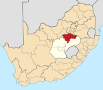 | |
| Ngwathe | ||
| Metsimaholo |
| |
| Mafube | ||
This Free State location article is a stub. You can help Wikipedia by expanding it. |
Текст в блоке "Читать" взят с сайта "Википедия" и доступен по лицензии Creative Commons Attribution-ShareAlike; в отдельных случаях могут действовать дополнительные условия.
Другой контент может иметь иную лицензию. Перед использованием материалов сайта WikiSort.org внимательно изучите правила лицензирования конкретных элементов наполнения сайта.
Другой контент может иметь иную лицензию. Перед использованием материалов сайта WikiSort.org внимательно изучите правила лицензирования конкретных элементов наполнения сайта.
2019-2025
WikiSort.org - проект по пересортировке и дополнению контента Википедии
WikiSort.org - проект по пересортировке и дополнению контента Википедии