world.wikisort.org - South_Africa
Mamusa Local Municipality is a local municipality in Dr Ruth Segomotsi Mompati District Municipality, North West Province, South Africa. The seat of local municipality is Schweizer-Reneke.
Mamusa | |
|---|---|
Local municipality | |
 Seal | |
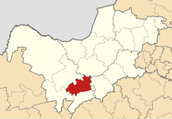 Location in the North West | |
| Country | South Africa |
| Province | North West |
| District | Dr Ruth Segomotsi Mompati |
| Seat | Schweizer-Reneke |
| Wards | 8 |
| Government | |
| • Type | Municipal council |
| • Mayor | (ANC) |
| Area | |
| • Total | 3,615 km2 (1,396 sq mi) |
| Population (2011)[2] | |
| • Total | 60,355 |
| • Density | 17/km2 (43/sq mi) |
| Racial makeup (2011) | |
| • Black African | 91.4% |
| • Coloured | 2.2% |
| • Indian/Asian | 0.5% |
| • White | 5.5% |
| First languages (2011) | |
| • Tswana | 85.1% |
| • Afrikaans | 7.2% |
| • Sotho | 2.2% |
| • English | 1.7% |
| • Other | 3.8% |
| Time zone | UTC+2 (SAST) |
| Municipal code | NW393 |
Politics
The municipal council consists of sixteen members elected by mixed-member proportional representation. Eight are elected by first-past-the-post voting in eight wards, while the remaining eight are chosen from party lists so that the total number of party representatives is proportional to the number of votes received. In the election of 1 November 2021 the African National Congress (ANC) won a majority of nine seats on the council.
The following table shows the results of the 2021 election.[3]
| Party | Ward | List | Total seats | |||||
|---|---|---|---|---|---|---|---|---|
| Votes | % | Seats | Votes | % | Seats | |||
| African National Congress | 7,651 | 54.47 | 7 | 7,725 | 56.51 | 2 | 9 | |
| Economic Freedom Fighters | 3,414 | 24.31 | 0 | 3,501 | 25.61 | 4 | 4 | |
| Freedom Front Plus | 890 | 6.34 | 1 | 912 | 6.67 | 0 | 1 | |
| Azanian Independent Community Movement | 804 | 5.72 | 0 | 823 | 6.02 | 1 | 1 | |
| Democratic Alliance | 396 | 2.82 | 0 | 375 | 2.74 | 1 | 1 | |
| Independent candidates | 656 | 4.67 | 0 | 0 | ||||
| 5 other parties | 234 | 1.67 | 0 | 335 | 2.45 | 0 | 0 | |
| Total | 14,045 | 100.00 | 8 | 13,671 | 100.00 | 8 | 16 | |
| Valid votes | 14,045 | 96.25 | 13,671 | 93.91 | ||||
| Invalid/blank votes | 547 | 3.75 | 887 | 6.09 | ||||
| Total votes | 14,592 | 100.00 | 14,558 | 100.00 | ||||
| Registered voters/turnout | 28,107 | 51.92 | 28,107 | 51.79 | ||||
Geography
The municipality covers an area of 3,615 square kilometres (1,396 sq mi) in the south-west part of North West province. At the time of the 2011 census it has a population of 60,355. According to the census, the predominant language in the municipality is Setswana, spoken by 85.1% of the population, followed by Afrikaans (7.2%), Sesotho (2.2%) and English (1.7%). 91.5% of the population identified as "Black African", 5.5% as "White", 2.2% as "Coloured", and 0.5% as "Indian or Asian". The 2016 Community Survey estimated that the population had increased to 64,000.
The principal town is Schweizer-Reneke, located in the centre of the municipality, which (including the township of Ipelegeng) had a population of 41,226 in 2011. Other settlements include Amalia (pop. 5,481) to the west, and Migdol (pop. 3,526) and Glaudina (pop. 2,368) to the north-east.
Roads radiate outwards from Schweizer-Reneke towards Vryburg, Delareyville, Wolmaransstad, Bloemhof, Christiana and Pudimoe. The road from Vryburg to Bloemhof is designated as provincial route R34, while the others are designated as regional routes R504 (Pudimoe–Wolmaransstad) and R506 (Christiana–Delareyville). The Coligny–Vermaas–Pudimoe railway line also passes through the municipality.
References
- "Contact list: Executive Mayors". Government Communication & Information System. Archived from the original on 14 July 2010. Retrieved 22 February 2012.
- "Statistics by place". Statistics South Africa. Retrieved 27 September 2015.
- "Election Result Table for LGE2021 — Mamusa". wikitable.frith.dev. Retrieved 4 December 2021.
External links
Municipalities of the North West | ||||||||||
|---|---|---|---|---|---|---|---|---|---|---|
| District and local |
|  | ||||||||
List of municipalities in the North West | ||||||||||
This North West Province location article is a stub. You can help Wikipedia by expanding it. |
На других языках
[de] Mamusa
Mamusa (englisch Mamusa Local Municipality) ist eine Lokalgemeinde im Distrikt Dr Ruth Segomotsi Mompati der südafrikanischen Provinz Nordwest. Der Verwaltungssitz befindet sich in Schweizer-Reneke. Bürgermeister ist K. Aron Motswane.[1]- [en] Mamusa Local Municipality
[ru] Мамуса (местный муниципалитет)
Мамуса (Mamusa) — местный муниципалитет в районе Рутх Сегомотси Момпати Северо-Западной провинции (ЮАР). Административный центр — Швейцер-Ренеке. Название муниципалитета в переводе с языка тсвана означает «Грудное вскармливание детей».Другой контент может иметь иную лицензию. Перед использованием материалов сайта WikiSort.org внимательно изучите правила лицензирования конкретных элементов наполнения сайта.
WikiSort.org - проект по пересортировке и дополнению контента Википедии