world.wikisort.org - South_Africa
Kwambonambi is a town in King Cetshwayo District Municipality in the KwaZulu-Natal province of South Africa.
Kwambonambi | |
|---|---|
 Kwambonambi  Kwambonambi | |
| Coordinates: 28.6°S 32.083333°E | |
| Country | South Africa |
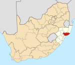
| Province | KwaZulu-Natal |
| District | King Cetshwayo |
| Municipality | uMfolozi |
| Area | |
| • Total | 3.27 km2 (1.26 sq mi) |
| Population (2011)[1] | |
| • Total | 2,872 |
| • Density | 880/km2 (2,300/sq mi) |
| Racial makeup (2011) | |
| • Black African | 82.6% |
| • Coloured | 0.6% |
| • Indian/Asian | 0.8% |
| • White | 15.6% |
| • Other | 0.4% |
| First languages (2011) | |
| • Zulu | 77.1% |
| • English | 11.2% |
| • Afrikaans | 8.7% |
| • Other | 2.9% |
| Time zone | UTC+2 (SAST) |
| PO box | 3915 |
| Area code | 035 |
Village, centre of sugar and timber areas, 29 km north-east of Empangeni, 30 km south-west of Mtubatuba and 30 km north of Richards Bay. Zulu, ‘place of the Mbonambi’, a tribe which lived there, the name means ‘ill-omen’.[2]
References
- "Sub Place Kwambonambi". Census 2011.
- "Dictionary of Southern African Place Names (Public Domain)". Human Science Research Council. p. 267.
Municipalities and communities of King Cetshwayo District Municipality, KwaZulu-Natal | ||
|---|---|---|
District seat: Richards Bay | ||
| uMhlathuze |
|  |
| uMlalazi | ||
| Nkandla | ||
| Mbonambi |
| |
| Ntambanana |
| |
| Mthonjaneni | ||
Authority control | |
|---|---|
| General |
|
| National libraries | |
This KwaZulu-Natal location article is a stub. You can help Wikipedia by expanding it. |
На других языках
[de] KwaMbonambi
KwaMbonambi (isiZulu; deutsch etwa: „Ort der Mbonambi“) ist ein Ort in der südafrikanischen Provinz KwaZulu-Natal. Er ist Verwaltungssitz der Gemeinde uMfolozi im Distrikt King Cetshwayo.- [en] Kwambonambi
Текст в блоке "Читать" взят с сайта "Википедия" и доступен по лицензии Creative Commons Attribution-ShareAlike; в отдельных случаях могут действовать дополнительные условия.
Другой контент может иметь иную лицензию. Перед использованием материалов сайта WikiSort.org внимательно изучите правила лицензирования конкретных элементов наполнения сайта.
Другой контент может иметь иную лицензию. Перед использованием материалов сайта WikiSort.org внимательно изучите правила лицензирования конкретных элементов наполнения сайта.
2019-2025
WikiSort.org - проект по пересортировке и дополнению контента Википедии
WikiSort.org - проект по пересортировке и дополнению контента Википедии