world.wikisort.org - South_Africa
De Waterkant is a sub-district of the suburb of Green Point, Cape Town. The neighbourhood is adjacent to the central business district on the southeastern end of Somerset Road. On the south, it is neighboured by the historically coloured district of Bo-Kaap.
De Waterkant | |
|---|---|
 | |
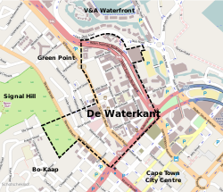 Street map of De Waterkant | |
 De Waterkant  De Waterkant | |
| Coordinates: 33°54′55″S 18°25′08″E | |
| Country | South Africa |
| Province | Western Cape |
| Municipality | City of Cape Town |
| Area | |
| • Total | 0.30 km2 (0.12 sq mi) |
| Population (2011)[1] | |
| • Total | 361 |
| • Density | 1,200/km2 (3,100/sq mi) |
| Racial makeup (2011) | |
| • Black African | 11.6% |
| • Coloured | 5.0% |
| • Indian/Asian | 5.5% |
| • White | 75.3% |
| • Other | 2.5% |
| First languages (2011) | |
| • English | 69.8% |
| • Afrikaans | 17.2% |
| • Sotho | 1.4% |
| • Other | 11.6% |
| Time zone | UTC+2 (SAST) |
| Postal code (street) | 8001 |
De Waterkant is a convenient address for many young professionals, the upper-class, and niche restaurants and retailers. The area is home to the Cape Quarter shopping mall[2] and Vega's Cape Town campus.[3]
References
- "Sub Place De Waterkant". Census 2011.
- "Contact Us". Cape Quarter. Retrieved 2016-02-08.
- "Vega Campuses". Vega. Archived from the original on 2016-03-02. Retrieved 2016-02-08.
Further reading
- Rink, Bradley Michael (2008). Village People: Quartering De Waterkant in discourse and bricks (Ph.D. thesis). University of Cape Town. Retrieved 30 June 2014.
| Wikimedia Commons has media related to De Waterkant. |
Cape Town | |||||||||||||||||||||||||||||||
|---|---|---|---|---|---|---|---|---|---|---|---|---|---|---|---|---|---|---|---|---|---|---|---|---|---|---|---|---|---|---|---|
City of Cape Town | |||||||||||||||||||||||||||||||
| |||||||||||||||||||||||||||||||
| |||||||||||||||||||||||||||||||
| |||||||||||||||||||||||||||||||
| |||||||||||||||||||||||||||||||
| |||||||||||||||||||||||||||||||
| |||||||||||||||||||||||||||||||
| |||||||||||||||||||||||||||||||
| |||||||||||||||||||||||||||||||
| |||||||||||||||||||||||||||||||
| |||||||||||||||||||||||||||||||
| |||||||||||||||||||||||||||||||
| Law |
|  | ||||||||
|---|---|---|---|---|---|---|---|---|---|---|
| People |
| |||||||||
| Organisations |
| |||||||||
| Sport | Jozi Cats | |||||||||
| Languages |
| |||||||||
| Gay villages |
| |||||||||
| Events |
| |||||||||
| Media |
| |||||||||
| Issues | Corrective rape | |||||||||
| Other |
| |||||||||
Category:LGBT in South Africa | ||||||||||
Текст в блоке "Читать" взят с сайта "Википедия" и доступен по лицензии Creative Commons Attribution-ShareAlike; в отдельных случаях могут действовать дополнительные условия.
Другой контент может иметь иную лицензию. Перед использованием материалов сайта WikiSort.org внимательно изучите правила лицензирования конкретных элементов наполнения сайта.
Другой контент может иметь иную лицензию. Перед использованием материалов сайта WikiSort.org внимательно изучите правила лицензирования конкретных элементов наполнения сайта.
2019-2025
WikiSort.org - проект по пересортировке и дополнению контента Википедии
WikiSort.org - проект по пересортировке и дополнению контента Википедии