world.wikisort.org - South_Africa
Dalton is a village in 11 kilometres (6.8 mi) east of New Hanover and 35 kilometres (22 mi) south of Greytown in the uMshwati Local Municipality of KwaZulu-Natal, South Africa
Dalton | |
|---|---|
 Dalton  Dalton | |
| Coordinates: 29°20′S 30°38′E | |
| Country | South Africa |
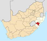
| Province | KwaZulu-Natal |
| District | UMgungundlovu |
| Municipality | uMshwathi |
| Established | 1850 |
| Area | |
| • Total | 1.28 km2 (0.49 sq mi) |
| Population (2011)[1] | |
| • Total | 1,493 |
| • Density | 1,200/km2 (3,000/sq mi) |
| Racial makeup (2011) | |
| • Black African | 81.4% |
| • Coloured | 0.7% |
| • Indian/Asian | 6.6% |
| • White | 9.6% |
| • Other | 1.7% |
| First languages (2011) | |
| • Zulu | 58.6% |
| • English | 21.3% |
| • Xhosa | 12.8% |
| • Afrikaans | 1.8% |
| • Other | 5.5% |
| Time zone | UTC+2 (SAST) |
| PO box | 3236 |
| Area code | 033 |
The town is nameed after North Dalton in Yorkshire, the hometown of Henry Boast, who organized an immigration to Natal in 1850 of people from Yorkshire. It is the railway junction for the Noodsberg line.[2]
The main local industry is the production of sugarcane, with the Union Cooperative and Illovo Noodsberg mills nearby.
References
- "Main Place Dalton". Census 2011.
- "Dictionary of Southern African Place Names (Public Domain)". Human Science Research Council. p. 128.
Municipalities and communities of uMgungundlovu District Municipality, KwaZulu-Natal | ||
|---|---|---|
District seat: Pietermaritzburg | ||
| uMshwathi |
|  |
| uMngeni |
| |
| Mpofana |
| |
| Impendle |
| |
| Msunduzi |
| |
| Mkhambathini |
| |
| Richmond |
| |
This KwaZulu-Natal location article is a stub. You can help Wikipedia by expanding it. |
Текст в блоке "Читать" взят с сайта "Википедия" и доступен по лицензии Creative Commons Attribution-ShareAlike; в отдельных случаях могут действовать дополнительные условия.
Другой контент может иметь иную лицензию. Перед использованием материалов сайта WikiSort.org внимательно изучите правила лицензирования конкретных элементов наполнения сайта.
Другой контент может иметь иную лицензию. Перед использованием материалов сайта WikiSort.org внимательно изучите правила лицензирования конкретных элементов наполнения сайта.
2019-2025
WikiSort.org - проект по пересортировке и дополнению контента Википедии
WikiSort.org - проект по пересортировке и дополнению контента Википедии