world.wikisort.org - South_Africa
Bonnievale is a settlement in the Cape Winelands District Municipality in the Western Cape province of South Africa.
Bonnievale | |
|---|---|
 Church street in Bonnievale | |
 Bonnievale  Bonnievale | |
| Coordinates: 33°55′39″S 20°6′2″E | |
| Country | South Africa |
| Province | Western Cape |
| District | Cape Winelands |
| Municipality | Langeberg |
| Area | |
| • Total | 27.07 km2 (10.45 sq mi) |
| Population (2011)[1] | |
| • Total | 9,092 |
| • Density | 340/km2 (870/sq mi) |
| Racial makeup (2011) | |
| • Black African | 11.1% |
| • Coloured | 75.3% |
| • Indian/Asian | 0.2% |
| • White | 10.7% |
| • Other | 2.7% |
| First languages (2011) | |
| • Afrikaans | 89.7% |
| • Xhosa | 6.0% |
| • English | 1.7% |
| • Sotho | 1.3% |
| • Other | 1.3% |
| Time zone | UTC+2 (SAST) |
| Postal code (street) | 6730 |
| PO box | 6730 |
| Area code | 023 |
The town is 64 km southeast of Worcester, in the Breede River Valley. It was founded in 1922, and was named after the railway siding called Vale at its opening in 1902 and Bonnie Vale in 1917. Municipal status was gained in April 1953.[2] Bonnievale is surrounded by the Langeberge and Riversonderend Mountains. Situated on the Cape Wine Route, the area caters to tourists[3] with locally made cheese and wine, along with private game reserves and extensive hiking trails.[4]
Gallery
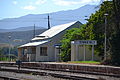 Old station building, 1922–2012
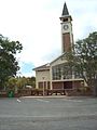 NG Church, built c. 1922
 DJ le Roux Museum
 Weltevrede vineyards


References
- "Main Place Bonnievale". Census 2011.
- "Dictionary of Southern African Place Names (Public Domain)". Human Science Research Council. p. 89.
- "Bonnievale Travel Information".
- "Home". info-bonnievale.co.za.
Municipalities and communities of Cape Winelands District Municipality, Western Cape | ||
|---|---|---|
District seat: Stellenbosch | ||
| Witzenberg |
|  |
| Drakenstein | ||
| Stellenbosch |
| |
| Breede Valley |
| |
| Langeberg |
| |
Authority control | |
|---|---|
| General |
|
| National libraries | |
This Western Cape location article is a stub. You can help Wikipedia by expanding it. |
На других языках
[de] Bonnievale
Bonnievale ist eine Stadt in der Gemeinde Langeberg, Distrikt Cape Winelands, Provinz Westkap in Südafrika, 180 Kilometer östlich von Kapstadt und 30 Kilometer südöstlich von Robertson am Ufer des Breede River gelegen. 2011 hatte der Ort 9092 Einwohner.[1] Eingerahmt ist die Stadt von den Langeberg im Nordosten und den Riviersonderend Mountains im Südwesten.- [en] Bonnievale, South Africa
[ru] Боннивейл
Боннивейл[1] (африк. и англ. Bonnievale) — небольшой город на юго-западе Южно-Африканской Республики, на территории Западно-Капской провинции. Входит в состав района Кейп-Вайнлендс. Является частью местного муниципалитета Лангеберх.Текст в блоке "Читать" взят с сайта "Википедия" и доступен по лицензии Creative Commons Attribution-ShareAlike; в отдельных случаях могут действовать дополнительные условия.
Другой контент может иметь иную лицензию. Перед использованием материалов сайта WikiSort.org внимательно изучите правила лицензирования конкретных элементов наполнения сайта.
Другой контент может иметь иную лицензию. Перед использованием материалов сайта WikiSort.org внимательно изучите правила лицензирования конкретных элементов наполнения сайта.
2019-2025
WikiSort.org - проект по пересортировке и дополнению контента Википедии
WikiSort.org - проект по пересортировке и дополнению контента Википедии