world.wikisort.org - Südafrika
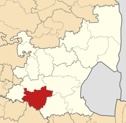
Lekwa (englisch Lekwa Local Municipality) ist eine Lokalgemeinde im Distrikt Gert Sibande der südafrikanischen Provinz Mpumalanga. Der Verwaltungssitz befindet sich in Standerton. Bürgermeister ist Lindokuhle Blessing Robert Dhlamini.[1]
| Lekwa Local Municipality of Lekwa | ||
|---|---|---|
 | ||
| Symbole | ||
| ||
| Basisdaten | ||
| Staat | Südafrika | |
| Provinz | Mpumalanga | |
| Distrikt | Gert Sibande | |
| Sitz | Standerton | |
| Fläche | 4585 km² | |
| Einwohner | 115.662 (Oktober 2011) | |
| Dichte | 25 Einwohner pro km² | |
| Schlüssel | MP305 | |
| ISO 3166-2 | ZA-MP | |
| Webauftritt | www.lekwalm.gov.za (englisch) | |
| Politik | ||
| Bürgermeister | Lindokuhle Blessing Robert Dhlamini | |

Die Gemeinde ist benannt nach dem isiZulu-Wort Ligwa für den Fluss Vaal, der die Gemeinde durchfließt.[2]
Städte und Orte
|
|
Bevölkerung
Von den 115.662 Einwohnern im Jahr 2011 auf einer Fläche von 4585 Quadratkilometern waren 84,2 % schwarz, 11,4 % weiß, 2,9 % Coloured und 1,2 % Inder bzw. Asiaten.[3] Erstsprache war zu 65 % isiZulu, zu 13 % Afrikaans, zu 10,1 % Sesotho, zu 3,5 % Englisch, zu 1,5 % isiXhosa, zu jeweils 1,1 % isiNdebele und Siswati, zu 0,7 % Setswana und zu 0,6 % Sepedi.[4]
Weblinks
- Website der Gemeinde (englisch)
Einzelnachweise
- Local Government Handbook. South Africa: Lekwa Local Municipality (MP305). auf www.municipalities.co.za (englisch).
- Department of Arts and Culture: Place Names. auf www.salanguages.com (englisch).
- Volkszählung 2011: Lekwa. abgerufen am 18. September 2020.
- Statistics South Africa: Lekwa. auf www.statssa.gov.za (englisch).
На других языках
- [de] Lekwa
[en] Lekwa Local Municipality
Lekwa Local Municipality is a South African local municipality situated in the southwest of the Gert Sibande District Municipality of Mpumalanga. Standerton, an urban node, is the seat of the Lekwa Local Municipality. The municipality was inaugurated on the 5th of December 2000 after the amalgamation the Standerton, Sakhile and Morgenzon councils.[3] Agriculture, forestry and fishing constitute about 30% of its economy. It is situated on open grassland plains of the Highveld region, which is traversed by the west-flowing Vaal River, for which it is named. Lekwa is the Sotho name for the Vaal River.[3] Lekwa's first two decades were marked by increasing maladministration, which culminated in a collapse in governance and service delivery by 2020.[4] This had negative consequences for its residents and businesses, the environment, and utilities which were not paid for their services.[5]Текст в блоке "Читать" взят с сайта "Википедия" и доступен по лицензии Creative Commons Attribution-ShareAlike; в отдельных случаях могут действовать дополнительные условия.
Другой контент может иметь иную лицензию. Перед использованием материалов сайта WikiSort.org внимательно изучите правила лицензирования конкретных элементов наполнения сайта.
Другой контент может иметь иную лицензию. Перед использованием материалов сайта WikiSort.org внимательно изучите правила лицензирования конкретных элементов наполнения сайта.
2019-2025
WikiSort.org - проект по пересортировке и дополнению контента Википедии
WikiSort.org - проект по пересортировке и дополнению контента Википедии