world.wikisort.org - Slovenia
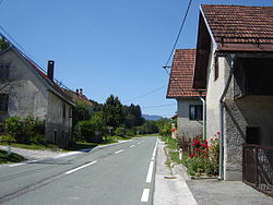
Nova Sela (pronounced [ˈnɔːʋa ˈseːla]; Slovene: Nova sela) is a settlement southeast of Banja Loka in the Municipality of Kostel in southern Slovenia. The area is part of the traditional region of Lower Carniola and is now included in the Southeast Slovenia Statistical Region.[2]
Nova Sela | |
|---|---|
 Nova Sela | |
 Nova Sela Location in Slovenia | |
| Coordinates: 45°30′20.11″N 14°53′16.81″E | |
| Country | |
| Traditional region | Lower Carniola |
| Statistical region | Southeast Slovenia |
| Municipality | Kostel |
| Area | |
| • Total | 2.52 km2 (0.97 sq mi) |
| Elevation | 543.2 m (1,782.2 ft) |
| Population (2002) | |
| • Total | 35 |
| [1] | |
References
External links
Текст в блоке "Читать" взят с сайта "Википедия" и доступен по лицензии Creative Commons Attribution-ShareAlike; в отдельных случаях могут действовать дополнительные условия.
Другой контент может иметь иную лицензию. Перед использованием материалов сайта WikiSort.org внимательно изучите правила лицензирования конкретных элементов наполнения сайта.
Другой контент может иметь иную лицензию. Перед использованием материалов сайта WikiSort.org внимательно изучите правила лицензирования конкретных элементов наполнения сайта.
2019-2025
WikiSort.org - проект по пересортировке и дополнению контента Википедии
WikiSort.org - проект по пересортировке и дополнению контента Википедии
