world.wikisort.org - Slovakia
Topoľovka is a village and municipality in Humenné District in the Prešov Region of north-east Slovakia.
Topoľovka | |
|---|---|
Municipality | |
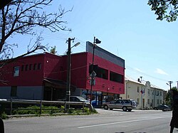
 Main street in Topoľovka, the centre of village. Buildings on the left are the commune council building with civil registry and rural market | |
 Topoľovka Location of Topoľovka in the Prešov Region  Topoľovka Location of Topoľovka in Slovakia | |
| Coordinates: 48°55′10″N 21°48′30″E | |
| Country | |
| Region | Prešov |
| District | Humenné |
| First mentioned | 1479 |
| Area | |
| • Total | 7.787 km2 (3.007 sq mi) |
| Elevation | 157 m (515 ft) |
| Population (31 December 2005) | |
| • Total | 824 |
| • Density | 110/km2 (270/sq mi) |
| Time zone | UTC+1 (CET) |
| • Summer (DST) | UTC+2 (CEST) |
| Postal code | 067 45 |
| Area code | +421-57 |
| Car plate | HE |
| Website | topolovka |
History
In historical records the village was first mentioned in 1479.
Geography
The municipality lies at an altitude of 157 metres (515 feet) and covers an area of 7.777 square kilometres (3.003 square miles). It has a population of about 825 people.
International relations
Twin towns — Sister cities
Topoľovka is twinned with:
 Bukowsko, Poland
External links
 Media related to Topoľovka at Wikimedia Commons
- Official website

- http://www.statistics.sk/mosmis/eng/run.html

На других языках
[de] Topoľovka
Topoľovka (ungarisch Topolóka – bis 1907 Topolovka) ist eine Gemeinde im Osten der Slowakei mit 800 Einwohnern (Stand 31. Dezember 2020), die zum Okres Humenné, einem Kreis des Prešovský kraj, gehört. Außerdem ist sie Teil der traditionellen Landschaft Zemplín.- [en] Topoľovka
[ru] Тополёвка (Словакия)
Тополёвка (словацк. Topoľovka) — село и одноимённая община в районе Гуменне Прешовского края Словакии. В письменных источниках начинает упоминаться с 1479 года[1].Текст в блоке "Читать" взят с сайта "Википедия" и доступен по лицензии Creative Commons Attribution-ShareAlike; в отдельных случаях могут действовать дополнительные условия.
Другой контент может иметь иную лицензию. Перед использованием материалов сайта WikiSort.org внимательно изучите правила лицензирования конкретных элементов наполнения сайта.
Другой контент может иметь иную лицензию. Перед использованием материалов сайта WikiSort.org внимательно изучите правила лицензирования конкретных элементов наполнения сайта.
2019-2025
WikiSort.org - проект по пересортировке и дополнению контента Википедии
WikiSort.org - проект по пересортировке и дополнению контента Википедии