world.wikisort.org - Slovakia
Kamenica nad Cirochou is a village and municipality in Humenné District in the Prešov Region of north-east Slovakia. By number of citizens it is the biggest village in the District. There are two rivers Cirocha and Kamenica that merge approximately 1 km off the village. There are 23 named streets with public lighting.
Kamenica nad Cirochou | |
|---|---|
Municipality | |
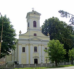
 Saint Stephen church | |
 Kamenica nad Cirochou Location of Kamenica nad Cirochou in the Prešov Region  Kamenica nad Cirochou Location of Kamenica nad Cirochou in Slovakia | |
| Coordinates: 48°56′N 22°00′E | |
| Country | |
| Region | Prešov |
| District | Humenné |
| First mentioned | 1317 |
| Area | |
| • Total | 17.57[1] km2 (6.78[1] sq mi) |
| Elevation | 184[2] m (604[2] ft) |
| Population (2021) | |
| • Total | 2,273[3] |
| Time zone | UTC+1 (CET) |
| • Summer (DST) | UTC+2 (CEST) |
| Postal code | 067 83[2] |
| Area code | +421 57[2] |
| Car plate | HE |
| Website | www |
History
Original site of village was significantly closer to Cirocha river. Change was induced probably by regular floods.
In historical records the village was first mentioned in 1317. King Robert I. gave it, together with other villages and town of Humenné, as a reward for faithful service to Drugeth family. It is assumed that village is older than with estimated origin in 13. century.
First known name of the village was Kemence and from 1416 it is called in official records Nagy Kemence. Mansion located in the village was built by Csáky family. Later it was owned by Andrássy family and Gejza Andrassy was the last count that lived in the mansion. In 1925 he sold part of land to citizens which lead to village expansion. In 1933 state took over management of woods and fields from the same count. With this change is linked origin of Military forests in the area and building electric sawmill.
Demographic evolution
| Mother language | 1880 | 1890 | 1900 | 1910 | 2011 |
|---|---|---|---|---|---|
| Slovak | 919 | 1028 | 949 | 868 | 2041 |
| Hungarian | 7 | 23 | 26 | 113 | 1 |
| German | 60 | 1 | 22 | 2 | 1 |
| Rusyn | 8 | 30 | |||
| Romani | 184 | ||||
| Ukrainian | 2 | ||||
| Czech | 6 | ||||
| Foreigners | 1 | ||||
| Other | 26 | 34 | 84 | 4 | |
| Not speaking | 15 | ||||
| Not identified | 110 |
| Religion | 1880 | 1890 | 1900 | 1910 | 2011 |
|---|---|---|---|---|---|
| Latin | 796 | 870 | 865 | 863 | 2011 |
| Greek-catholic | 149 | 183 | 152 | 139 | 161 |
| Judaism | 54 | 24 | 20 | 40 | |
| Evangelical Church of the Augsburg Confession | 3 | 1 | 1 | 10 | 7 |
| Calvinism | 1 | 15 | |||
| Eastern Orthodox | 17 | ||||
| Jehovah's Witnesses | 1 | ||||
| United Methodist Church | 1 | ||||
| Czechoslovak Hussite Church | 1 | ||||
| Other | 1 | ||||
| without religion | 48 | ||||
| Not identified | 131 |
Source: Statistical office of the Slovak republic
Geography
The municipality lies at an altitude of 179 metres and covers an area of 17.573 km². It has a population of about 2340 people.
Airports
- Humenne-Kamenica Airport - Main airport of the Humenné District, Humenne-Kamenica Airport is located here.
Sights
- Classicist mansion from 1773 (at the moment closed to the public).
- Church of St. Stephen from 1782.
References
- "Hustota obyvateľstva - obce [om7014rr_ukaz: Rozloha (Štvorcový meter)]". www.statistics.sk (in Slovak). Statistical Office of the Slovak Republic. 2022-03-31. Retrieved 2022-03-31.
- "Základná charakteristika". www.statistics.sk (in Slovak). Statistical Office of the Slovak Republic. 2015-04-17. Retrieved 2022-03-31.
- "Počet obyvateľov podľa pohlavia - obce (ročne)". www.statistics.sk (in Slovak). Statistical Office of the Slovak Republic. 2022-03-31. Retrieved 2022-03-31.
External links
 Media related to Kamenica nad Cirochou at Wikimedia Commons
- Official website

- http://www.kamenicanadcirochou.sk/
На других языках
[de] Kamenica nad Cirochou
Kamenica nad Cirochou (bis 1927 slowakisch „Kamenica“; ungarisch Nagykemence) ist mit 2300 Einwohnern nach der Bezirksstadt Humenné die größte Gemeinde im Okres Humenné in der Ostslowakei.- [en] Kamenica nad Cirochou
[ru] Каменица-над-Цирохоу
Каменица-над-Цирохоу (словацк. Kamenica nad Cirochou) — село и одноимённая община в районе Гуменне Прешовского края Словакии. В письменных источниках начинает упоминаться с 1317 года[1].Другой контент может иметь иную лицензию. Перед использованием материалов сайта WikiSort.org внимательно изучите правила лицензирования конкретных элементов наполнения сайта.
WikiSort.org - проект по пересортировке и дополнению контента Википедии