world.wikisort.org - Slovakia
Súľov-Hradná (Hungarian: Szulyóváralja) is a village and municipality in Bytča District in the Žilina Region of northern Slovakia.
Súľov-Hradná | |
|---|---|
Village | |
 Aerial view on Sulov | |
 Súľov-Hradná Location of Súľov-Hradná in Slovakia | |
| Coordinates: 49°10′N 18°36′E | |
| Country | Slovakia |
| Region | Žilina |
| District | Bytča |
| First mentioned | 1193 |
| Area | |
| • Total | 22.93[1] km2 (8.85[1] sq mi) |
| Elevation | 418[2] m (1,371[2] ft) |
| Population (2021) | |
| • Total | 985[3] |
| Postal code | 013 52[2] |
| Area code | +421 41[2] |
| Car plate | BY |
History
In historical records the village was first mentioned in 1193.
Geography
The municipality lies at an altitude of 400 metres and covers an area of 22.953 km². It has a population of about 929 people.[4]
The village is situated within the Súľov Mountains, and the highest mountain of the picturesque Súľov Rocks, Zibrid (867 m), is part of Súľov-Hradná's territory.
Gallery
 Church in Sulov
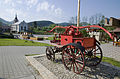 Square with a church and a historical fire truck
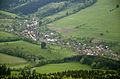 The municipality Súľov-Hradná - Hradná part
 Súľov Rocks


References
- "Hustota obyvateľstva - obce [om7014rr_ukaz: Rozloha (Štvorcový meter)]". www.statistics.sk (in Slovak). Statistical Office of the Slovak Republic. 2022-03-31. Retrieved 2022-03-31.
- "Základná charakteristika". www.statistics.sk (in Slovak). Statistical Office of the Slovak Republic. 2015-04-17. Retrieved 2022-03-31.
- "Počet obyvateľov podľa pohlavia - obce (ročne)". www.statistics.sk (in Slovak). Statistical Office of the Slovak Republic. 2022-03-31. Retrieved 2022-03-31.
- Mestská a obecná štatistika SR
External links
- Municipal website (in Slovak)
Authority control | |
|---|---|
| General | |
| National libraries | |
| Other |
|
This Žilina Region geography article is a stub. You can help Wikipedia by expanding it. |
На других языках
[de] Súľov-Hradná
Súľov-Hradná (ungarisch Szulyóváralja – bis 1902 Szúlyóhradna) ist eine Gemeinde im Okres Bytča innerhalb des Žilinský kraj in der Slowakei mit etwa 900 Einwohnern.- [en] Súľov-Hradná
Текст в блоке "Читать" взят с сайта "Википедия" и доступен по лицензии Creative Commons Attribution-ShareAlike; в отдельных случаях могут действовать дополнительные условия.
Другой контент может иметь иную лицензию. Перед использованием материалов сайта WikiSort.org внимательно изучите правила лицензирования конкретных элементов наполнения сайта.
Другой контент может иметь иную лицензию. Перед использованием материалов сайта WikiSort.org внимательно изучите правила лицензирования конкретных элементов наполнения сайта.
2019-2026
WikiSort.org - проект по пересортировке и дополнению контента Википедии
WikiSort.org - проект по пересортировке и дополнению контента Википедии