world.wikisort.org - Slovakia
Plavecké Podhradie (Hungarian: Detrekőváralja) is a village and municipality in western Slovakia in the Malacky District in the Bratislava region.
This article needs additional citations for verification. (February 2013) |
Plavecké Podhradie | |
|---|---|
Municipality | |
 | |
 Coat of arms | |
 Plavecké Podhradie Location of Plavecké Podhradie in the Bratislava Region  Plavecké Podhradie Plavecké Podhradie (Slovakia) | |
| Coordinates: 48°29′N 17°16′E | |
| Country | Slovakia |
| Region | Bratislava |
| District | Malacky |
| First mentioned | 1247 |
| Area | |
| • Total | 21.18[1] km2 (8.18[1] sq mi) |
| Elevation | 218[2] m (715[2] ft) |
| Population (2021) | |
| • Total | 715[3] |
| Postal code | 906 36[2] |
| Area code | +421 34[2] |
| Car plate | MA |
| Website | www.plpodhradie.sk |
History
In historical records the village was first mentioned in 1247 AD.
Geography
The village lies at an altitude of 256 metres and covers an area of 21.188 km².
Population
On 31 December 2011, it had a population of 686 people.[4]
Infrastructure
Plavecké Podhradie lies on the street from Lozorno and Jablonica. It can be reached by train from Zohor, seasonally also by trains starting in Záhorská Ves on the border to Austria.
Sights
The Plavecky Castle and few caves in the Little Carpathians are located nearby. There is also old Celtic oppidum, renaissance chateau of Pállfy family and ruins of medieval monastery.
Plavecky castle (remains)
The original castle was built in the 13th century. The middle part consisted of a Gothic castle with rectangular tower and the palace. In the 16th century it was expensively rebuilt into renaissance fortress with low courtyards. It was continually fortified and maintained during the 17th century, when new cannon bastions were built. In 1706 it was damaged by the army and so became dilapidated in the 18th century. The remains are visible from surrounding environment, part of Zahorie district can be seen from the remains. Water font is located near the remains.
Gallery
 Cave PP1
 Cave Pri Kríži
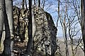 Celtic site Pohanská
 Plavecky castle
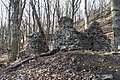 Ruins of monastery church


References
- "Hustota obyvateľstva - obce [om7014rr_ukaz: Rozloha (Štvorcový meter)]". www.statistics.sk (in Slovak). Statistical Office of the Slovak Republic. 2022-03-31. Retrieved 2022-03-31.
- "Základná charakteristika". www.statistics.sk (in Slovak). Statistical Office of the Slovak Republic. 2015-04-17. Retrieved 2022-03-31.
- "Počet obyvateľov podľa pohlavia - obce (ročne)". www.statistics.sk (in Slovak). Statistical Office of the Slovak Republic. 2022-03-31. Retrieved 2022-03-31.
- http://portal.statistics.sk/files/Sekcie/sek_600/Demografia/Obyvatelstvo/tabulky/pocet_obyvatelov/2011/poc_obyv_2011_n.zip Štatistický úrad Slovenskej republiky – 31. december 2011 (ZIP 128,1 kB)
External links
![]() Media related to Plavecké Podhradie at Wikimedia Commons
Media related to Plavecké Podhradie at Wikimedia Commons
- Official page
- https://web.archive.org/web/20070513023228/http://www.statistics.sk/mosmis/eng/run.html
Municipalities of Malacky District | ||
|---|---|---|
| ||
This article relies largely or entirely on a single source. (November 2007) |
| Authority control: National libraries |
|---|
This Bratislava location article is a stub. You can help Wikipedia by expanding it. |
На других языках
[de] Plavecké Podhradie
Plavecké Podhradie (slowakisch bis 1927 „Plavecký Podhrad“; deutsch Blasenstein oder Plasenstein, ungarisch Detrekőváralja) ist eine Gemeinde im Okres Malacky innerhalb des Bratislavský kraj in der Slowakei.- [en] Plavecké Podhradie
Другой контент может иметь иную лицензию. Перед использованием материалов сайта WikiSort.org внимательно изучите правила лицензирования конкретных элементов наполнения сайта.
WikiSort.org - проект по пересортировке и дополнению контента Википедии