world.wikisort.org - Slovakia
Hurbanovo (until 1948 Stará Ďala, Hungarian: Ógyalla, German: Altdala) is a town and large municipality in the Komárno District in the Nitra Region of south-west Slovakia. In 1948, its Slovak name was changed to Hurbanovo, named after Slovak writer Jozef Miloslav Hurban.
Hurbanovo
Ógyalla | |
|---|---|
Town | |
 Saint Ladislaus Church | |
 Flag  Coat of arms | |
 Hurbanovo Location of Hurbanovo in Slovakia | |
| Coordinates: 47°52′32″N 18°11′36″E | |
| Country | Slovakia |
| Region | Nitra |
| District | Komárno |
| First mentioned | 1329 |
| Area | |
| • Total | 59.93[1] km2 (23.14[1] sq mi) |
| Elevation | 114[2] m (374[2] ft) |
| Population (2021) | |
| • Total | 7,375[3] |
| Postal code | 947 01[2] |
| Area code | +421 35[2] |
| Car plate | KN |
| Website | www.hurbanovo.sk |
History
In historical records the town was first mentioned in 1329.
Geography
The town lies at an elevation of 115 metres and covers an area of 59.943 km2. Hurbanovo is situated on the climatically warmest location of the Podunajská nížina lowland, and it is located on the left bank of the Žitava river in the area with an altitude around 115 metres above the sea level.
Demographics
According to the 2021 census, the municipality had 7,467 inhabitants. 3,780 (or 50,62 %) of inhabitants were Slovaks, 3,038 (or 40,69 %) Hungarians, 179 (2,4 %) Roma, 28 (0,37 %) Czechs, 468 others and unspecified.[4]
Government
The town has a birth registry, a police force and a tax office.
Facilities
The town has a public library, a DVD rental store and a cinema. It also has a football pitch. The town has a commercial bank and insurance company and number of general and food stores. It has a doctor's surgery and an outpatient facility for children and adolescents and a gynaecologist. A brewery, called Zlatý Bažant, also operates in the town.
Transport
The town has a garage and petrol station and a railway station.
Famous people
- Gabriela Dudeková, historian
- Árpád Feszty, artist, painter
- Miklós Konkoly-Thege, astronomer
Climate
Climate in this area has mild differences between highs and lows, and there is adequate rainfall year-round. The Köppen Climate Classification subtype for this climate is "Cfb". (Marine West Coast Climate).[5] On 20 July 2007, Hurbanovo recorded a temperature of 40.3 °C (104.5 °F), which is the highest temperature to have ever been recorded in Slovakia.[6]
| Climate data for Hurbanovo | |||||||||||||
|---|---|---|---|---|---|---|---|---|---|---|---|---|---|
| Month | Jan | Feb | Mar | Apr | May | Jun | Jul | Aug | Sep | Oct | Nov | Dec | Year |
| Record high °C (°F) | 13.4 (56.1) |
20.8 (69.4) |
25.7 (78.3) |
30.0 (86.0) |
33.4 (92.1) |
34.8 (94.6) |
40.3 (104.5) |
38.0 (100.4) |
33.4 (92.1) |
27.6 (81.7) |
23.2 (73.8) |
19.0 (66.2) |
40.3 (104.5) |
| Average high °C (°F) | 1.6 (34.9) |
4.8 (40.6) |
10.6 (51.1) |
16.6 (61.9) |
21.7 (71.1) |
24.7 (76.5) |
26.8 (80.2) |
26.2 (79.2) |
22.3 (72.1) |
16.3 (61.3) |
8.4 (47.1) |
3.2 (37.8) |
15.3 (59.5) |
| Daily mean °C (°F) | −1.5 (29.3) |
1.0 (33.8) |
5.4 (41.7) |
10.7 (51.3) |
15.6 (60.1) |
18.7 (65.7) |
20.2 (68.4) |
19.5 (67.1) |
15.5 (59.9) |
10.2 (50.4) |
4.7 (40.5) |
0.4 (32.7) |
10.0 (50.0) |
| Average low °C (°F) | −4.7 (23.5) |
−2.5 (27.5) |
0.9 (33.6) |
5.0 (41.0) |
9.6 (49.3) |
12.7 (54.9) |
13.8 (56.8) |
13.5 (56.3) |
10.1 (50.2) |
5.4 (41.7) |
1.4 (34.5) |
−2.5 (27.5) |
5.2 (41.4) |
| Record low °C (°F) | −23.0 (−9.4) |
−22.4 (−8.3) |
−21.4 (−6.5) |
−5.3 (22.5) |
−1.8 (28.8) |
2.2 (36.0) |
4.5 (40.1) |
4.5 (40.1) |
−1.7 (28.9) |
−1.6 (29.1) |
−14.1 (6.6) |
−21.0 (−5.8) |
−23.0 (−9.4) |
| Average precipitation mm (inches) | 33.9 (1.33) |
34.0 (1.34) |
26.6 (1.05) |
38.8 (1.53) |
55.3 (2.18) |
60.8 (2.39) |
50.7 (2.00) |
37.0 (1.46) |
38.9 (1.53) |
32.2 (1.27) |
53.7 (2.11) |
39.8 (1.57) |
521.7 (20.54) |
| Average precipitation days (≥ 1.0 mm) | 6.9 | 6.4 | 5.9 | 6.4 | 8.3 | 8.3 | 7.1 | 6.8 | 5.6 | 5.0 | 7.8 | 7.5 | 82.0 |
| Average relative humidity (%) | 83 | 79 | 72 | 65 | 66 | 68 | 66 | 69 | 74 | 76 | 82 | 85 | 74 |
| Mean monthly sunshine hours | 61.9 | 85.0 | 134.3 | 178.8 | 229.0 | 237.4 | 259.4 | 236.8 | 184.3 | 143.7 | 69.1 | 51.6 | 1,871.3 |
| Source: NOAA[7] OGIMET[8] | |||||||||||||
Twin towns — sister cities
Hurbanovo is twinned with:[9]
 Lovran, Croatia
 Pápa, Hungary
 Žlutice, Czech Republic
Gallery
 Local Zlatý Bažant brewery
 Church of Saint Anne
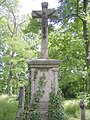 Bohatá Cemetery


See also
- List of municipalities and towns in Slovakia
References
- "Hustota obyvateľstva - obce [om7014rr_ukaz: Rozloha (Štvorcový meter)]". www.statistics.sk (in Slovak). Statistical Office of the Slovak Republic. 2022-03-31. Retrieved 2022-03-31.
- "Základná charakteristika". www.statistics.sk (in Slovak). Statistical Office of the Slovak Republic. 2015-04-17. Retrieved 2022-03-31.
- "Počet obyvateľov podľa pohlavia - obce (ročne)". www.statistics.sk (in Slovak). Statistical Office of the Slovak Republic. 2022-03-31. Retrieved 2022-03-31.
- "SODB2021 - Population - Basic results". www.scitanie.sk. Retrieved 2022-07-21.
- Climate Summary for Hurbanovo
- "Historical Extremes: Review of historical extremes (extreme values) of selected meteorological elements at the territory of Slovak republic". Slovak Hydrometeorological Institute. Archived from the original on 14 October 2016. Retrieved 9 October 2016.
- "Hurbanovo Climate Normals 1961-1990". National Oceanic and Atmospheric Administration. Retrieved March 3, 2015.
- "11858: Hurbanovo (Slovakia)". OGIMET. 26 February 2021. Retrieved 26 February 2021.
- "Partnerské mestá". hurbanovo.sk (in Slovak). Hurbanovo. Retrieved 2019-09-09.
Genealogical resources
The records for genealogical research are available at the state archive "Státný archiv in Nitra, Slovakia"
- Roman Catholic church records (births/marriages/deaths): 1764-1918 (parish A)
- Reformated church records (births/marriages/deaths): 1793-1942 (parish A)
External links
Municipalities of Komárno District | ||
|---|---|---|
| ||
Authority control | |
|---|---|
| General | |
| National libraries | |
| Other |
|
На других языках
[de] Hurbanovo
Hurbanovo, ungarisch Ógyalla (bis 1948 slowakisch Stará Ďala; deutsch Altdala) ist eine Stadt in der Slowakei im Nitriansky kraj.- [en] Hurbanovo
[ru] Гурбаново
Гу́рбаново (словацк. Hurbanovo, до 1948 Stará Ďala, нем. Altdala, венг. Ógyalla) — город в южной Словакии на реке Житава. Население — около 8 тыс. человек, среди которых венгры (50 %), словаки (46 %) и цыгане (2,6 %).Другой контент может иметь иную лицензию. Перед использованием материалов сайта WikiSort.org внимательно изучите правила лицензирования конкретных элементов наполнения сайта.
WikiSort.org - проект по пересортировке и дополнению контента Википедии