world.wikisort.org - Slovakia
Chynorany (Hungarian: Kinorány) is a village and municipality in Partizánske District in the Trenčín Region of western Slovakia.[4]
Chynorany | |
|---|---|
Municipality | |
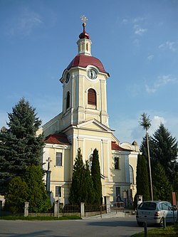
 St. Mary's Church of the Assumption | |
 Chynorany Location of Chynorany in the Trenčín Region  Chynorany Chynorany (Slovakia) | |
| Coordinates: 48°36′30″N 18°16′0″E | |
| Country | Slovakia |
| Region | Trenčín |
| District | Partizánske |
| First mentioned | 1243 |
| Area | |
| • Total | 10.35[1] km2 (4.00[1] sq mi) |
| Elevation | 175[2] m (574[2] ft) |
| Population (2021) | |
| • Total | 2,699[3] |
| Postal code | 956 33[2] |
| Area code | +421 38[2] |
| Car plate | PE |
| Website | www.chynorany.sk |
The village is located on the right bank of the river Nitra, approximately in the middle between the towns of Partizánske and Topoľčany. Northwest the terrain curves into the Bojice hillside, following the mountain range of Považský Inovec. To the south and east, behind the river Nitra, rises the mountain range of Tribeč.
Partizánske is 10 km northeast, Topoľčany 12 km southwest and Bánovce nad Bebravou 15 km north from Chynorany.
Etymology
The name is derived from a duty to guard a local ford at early morning. Slovak: chyn-, chyniť – to pretend, to lie (here also ambush, the word is preserved e.g. in Serbian as hiniti), ran-, raný, ranný – early, morning.[5]
History
In historical records, the village was first mentioned in 1243.
Geography
The municipality lies at an altitude of 178 metres (584 ft) and covers an area of 10.351 square kilometres (3.997 sq mi). It has a population of about 2723 people.
See also
- List of municipalities and towns in Slovakia
References
- "Hustota obyvateľstva - obce [om7014rr_ukaz: Rozloha (Štvorcový meter)]". www.statistics.sk (in Slovak). Statistical Office of the Slovak Republic. 2022-03-31. Retrieved 2022-03-31.
- "Základná charakteristika". www.statistics.sk (in Slovak). Statistical Office of the Slovak Republic. 2015-04-17. Retrieved 2022-03-31.
- "Počet obyvateľov podľa pohlavia - obce (ročne)". www.statistics.sk (in Slovak). Statistical Office of the Slovak Republic. 2022-03-31. Retrieved 2022-03-31.
- "Statistical Office of the Slovak Republic" (PDF). Výsledky SODB 2011. Štatistický úrad SR. Archived from the original (PDF) on 12 October 2013. Retrieved 19 August 2012.
- Krajčovič, Rudolf (2009). "Z lexiky stredovekej slovenčiny s výkladmi názvov obcí a miest (16)". Kultúra slova (in Slovak). Martin: Vydavateľstvo Matice slovenskej (4): 219.
Genealogical resources
The records for genealogical research are available at the state archive "Statny Archiv in Nitra, Slovakia"
- Roman Catholic church records (births/marriages/deaths): 1707–1946 (parish A)
External links
![]() Media related to Chynorany at Wikimedia Commons
Media related to Chynorany at Wikimedia Commons
- Official page
- https://web.archive.org/web/20160402002416/http://chynorany.e-obce.sk/
- Surnames of living people in Chynorany
На других языках
[de] Chynorany
Chynorany (ungarisch Kinorány – bis 1907 Chinorán) ist eine Gemeinde in der Westslowakei.- [en] Chynorany
Другой контент может иметь иную лицензию. Перед использованием материалов сайта WikiSort.org внимательно изучите правила лицензирования конкретных элементов наполнения сайта.
WikiSort.org - проект по пересортировке и дополнению контента Википедии