world.wikisort.org - Slovakia
Budiná (Hungarian: Budaszállás) is a village and municipality in the Lučenec District in the Banská Bystrica Region of Slovakia.
Budiná | |
|---|---|
Municipality | |
 | |
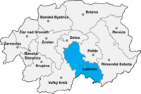
 Budiná Location of Budiná in the Banská Bystrica Region  Budiná Location of Budiná in Slovakia | |
| Coordinates: 48°28′N 19°29′E | |
| Country | |
| Region | Banská Bystrica |
| District | Lučenec |
| First mentioned | 1393 |
| Area | |
| • Total | 17.3 km2 (6.7 sq mi) |
| Elevation | 629 m (2,064 ft) |
| Time zone | UTC+1 (CET) |
| • Summer (DST) | UTC+2 (CEST) |
| Postal code | 985 12 (pošta Tuhár) |
| Area code | +421-47 |
| Car plate | LC |
History
In historical records, the village was first mentioned in 1393 (1393 Brtolehutaya, 1467 Budalehotha). It belonged to Divín castle. From 1554 to 1595 it suffered Turkish occupation.
External links
 Media related to Budiná at Wikimedia Commons
- https://web.archive.org/web/20071217080336/http://www.statistics.sk/mosmis/eng/run.html
- http://www.e-obce.sk/obec/budina/budina.html
Municipalities of Lučenec District | ||
|---|---|---|
| ||
| Authority control: National libraries |
|---|
This Banská Bystrica Region geography article is a stub. You can help Wikipedia by expanding it. |
На других языках
[de] Budiná
Budiná (ungarisch Budaszállás – bis 1907 Budalehota)[1] ist eine Gemeinde im Süden der Slowakei mit 218 Einwohnern (Stand 31. Dezember 2020). Sie gehört zum Okres Lučenec, einem Kreis des Banskobystrický kraj, und ist zugleich Teil der traditionellen Landschaft Novohrad.- [en] Budiná
Текст в блоке "Читать" взят с сайта "Википедия" и доступен по лицензии Creative Commons Attribution-ShareAlike; в отдельных случаях могут действовать дополнительные условия.
Другой контент может иметь иную лицензию. Перед использованием материалов сайта WikiSort.org внимательно изучите правила лицензирования конкретных элементов наполнения сайта.
Другой контент может иметь иную лицензию. Перед использованием материалов сайта WikiSort.org внимательно изучите правила лицензирования конкретных элементов наполнения сайта.
2019-2026
WikiSort.org - проект по пересортировке и дополнению контента Википедии
WikiSort.org - проект по пересортировке и дополнению контента Википедии