world.wikisort.org - Serbia
Golubac (Serbian Cyrillic: Голубац, pronounced [ɡǒlubats]; Romanian: Golubăț) is a village and municipality located in the Braničevo District of eastern Serbia. Situated on the right side of the Danube river, it is bordered by Romania to the east, Veliko Gradište to the west and Kučevo to the south. The population of the village is 1,655 and the population of the municipality is 8,331. Due to many nearby archeological sites and the Đerdap national park, the village is a popular tourist, fishing and sailing destination.
Golubac
| |
|---|---|
Village and municipality | |
 Town Center | |
 Coat of arms | |
 Location of the municipality of Golubac within Serbia | |
| Coordinates: 44°39′N 21°38′E | |
| Country | |
| Region | Southern and Eastern Serbia |
| District | Braničevo |
| Settlements | 24 |
| Government | |
| • Mayor | Nebojša Miović (SNS) |
| Area | |
| • Town | 41.74 km2 (16.12 sq mi) |
| • Municipality | 367.29 km2 (141.81 sq mi) |
| Elevation | 72 m (236 ft) |
| Population (2011 census)[2] | |
| • Town | 1,653 |
| • Town density | 40/km2 (100/sq mi) |
| • Municipality | 8,331 |
| • Municipality density | 23/km2 (59/sq mi) |
| Time zone | UTC+1 (CET) |
| • Summer (DST) | UTC+2 (CEST) |
| Postal code | 12223 |
| Area code | +381(0)12 |
| Car plates | PO |
| Climate | Cfb |
| Website | www |
Name
In Serbian, the town is known as Golubac (Голубац), derived from golub ("pigeon" or "dove") and is therefore often translated as "the town of doves." Other names: Romanian: Golubăț (also known as Golumbacu Mare or Columbacu), Hungarian: Galambóc, German: Taubenberg and Turkish: Güvercinlik meaning "dovecote."
Historically, it was known as Columbria in Latin, a contraction of (castrum) Columbaria meaning "city of pigeons" (Latin: Columba, Greek: kòlymbos), and as a city derived from Cuppae during pre-Roman times.
History
It was a stronghold called Cuppae during Roman and Early Byzantine times (1-6th century) and turned into a city (Columbria) in 554/5 AD.[3]
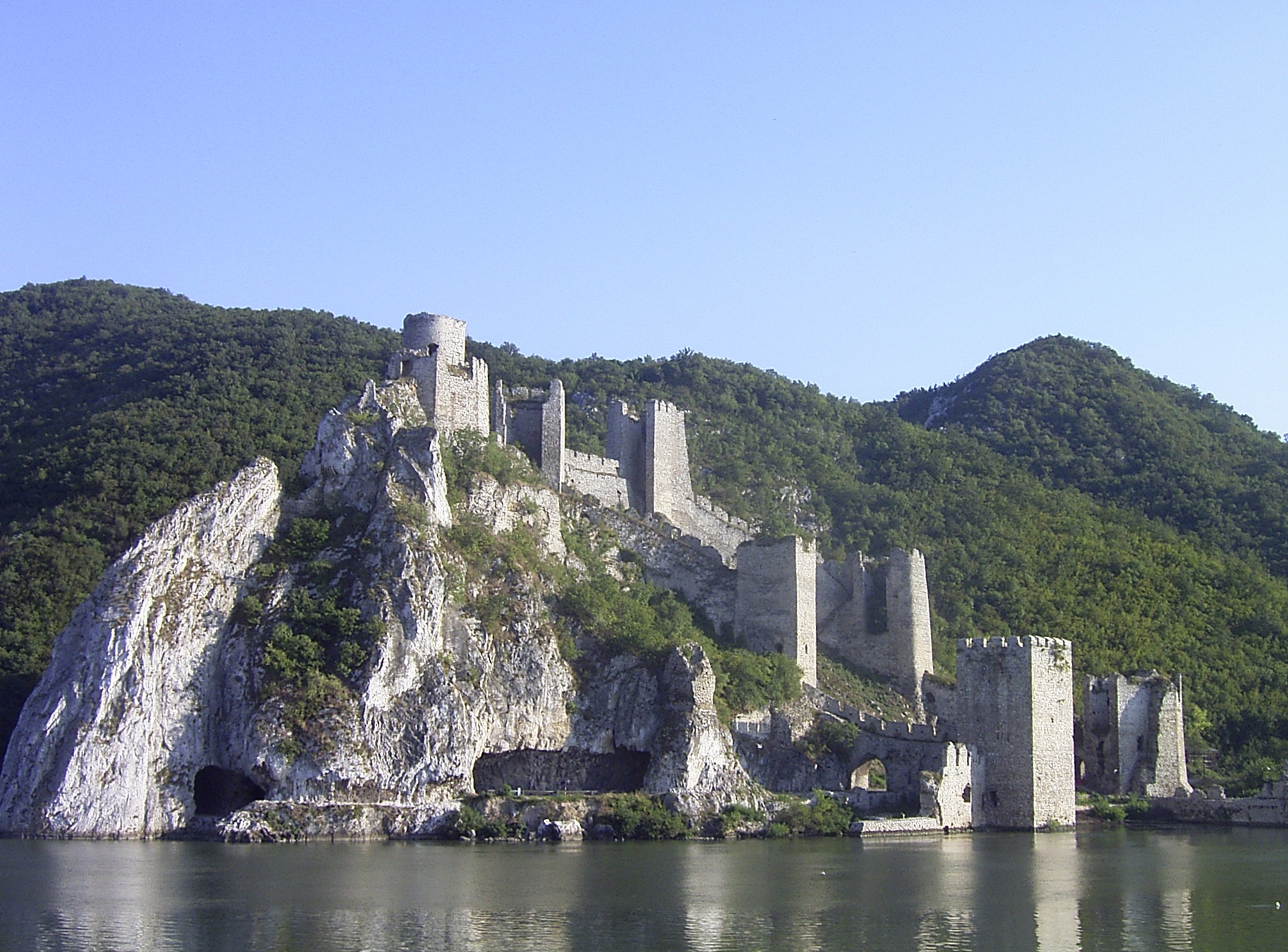
Archeological sites include the remnants of one of Roman Emperor Trajan's tables near Trajan's Bridge, found along his road through the Danube's Iron Gates; and the Roman fortress Diana. Golubac fortress, 4 km downstream, is from the 14th century and also of interest. The fortress was the scene of a battle against the Turks in 1428, where the Polish knight Zawisza Czarny was captured and executed by the Turks.
Charles I of Hungary conquered the castle in 1334. In 1387 Lazar of Serbia sieged it. Becoming a Hungarian ally in 1403–04, he received large possessions, including the important Belgrade and Golubac Fortress. The Turkish occupied it for the first time in 1391, but after that, Péter Perényi recaptured it. King Sigismund of Hungary acquired Golubac by a contract in 1427, but its Serbian captain sold it to the Turks for twelve thousand golds. Sigismund sieged the fortress in spring 1428 in response, but the mission was a failure, the King himself was almost killed by the Turks. In 1458, Matthias Corvinus tried to recapture it, but the siege was interrupted by Hungarian internal conflicts.
From 1929 to 1941, Golubac was part of the Morava Banovina of the Kingdom of Yugoslavia.
Demographics
According to the 2011 census results, the municipality of Golubac has a population of 8,331 inhabitants.
| Year | Pop. | ±% p.a. |
|---|---|---|
| 1948 | 14,844 | — |
| 1953 | 15,166 | +0.43% |
| 1961 | 15,320 | +0.13% |
| 1971 | 14,178 | −0.77% |
| 1981 | 13,541 | −0.46% |
| 1991 | 12,513 | −0.79% |
| 2002 | 9,913 | −2.10% |
| 2011 | 8,331 | −1.91% |
| Source: [4] | ||
Ethnic groups
The ethnic composition of the municipality:[5]
| Ethnic group | Population | % |
|---|---|---|
| Serbs | 7,576 | 90.94% |
| Vlachs | 424 | 5.09% |
| Romani | 52 | 0.62% |
| Romanians | 47 | 0.56% |
| Yugoslavs | 13 | 0.16% |
| Montenegrins | 9 | 0.11% |
| Macedonians | 7 | 0.08% |
| Croats | 6 | 0.07% |
| Hungarians | 5 | 0.06% |
| Others | 192 | 2.30% |
| Total | 8,331 |
Economy
The following table gives a preview of total number of employed people per their core activity (as of 2017):[6]
| Activity | Total |
|---|---|
| Agriculture, forestry and fishing | 47 |
| Mining | 45 |
| Processing industry | 183 |
| Distribution of power, gas and water | 1 |
| Distribution of water and water waste management | 36 |
| Construction | 39 |
| Wholesale and retail, repair | 182 |
| Traffic, storage and communication | 30 |
| Hotels and restaurants | 90 |
| Media and telecommunications | 3 |
| Finance and insurance | 5 |
| Property stock and charter | - |
| Professional, scientific, innovative and technical activities | 38 |
| Administrative and other services | 39 |
| Administration and social assurance | 114 |
| Education | 116 |
| Healthcare and social work | 70 |
| Art, leisure and recreation | 25 |
| Other services | 30 |
| Total | 1,091 |
Tourism
The Iron Gate national park is noted for its natural environment and its hunting grounds, as well as its hiking trails.[citation needed] The village's quay along the Danube river is popular for more relaxed hiking.[citation needed]
Sailing
Golubac has become a well-known sailing site.[citation needed] The Sailing Center of the Sailing Association of Serbia, which the Serbian National Team uses for ground preparations before major sailing events, is located in Golubac. One of the events is a sailing Regatta, which is traditionally held in August. During the summer, the Center holds an Optimist Class sailing camp, where beginners can learn from the best Serbian sailors and their international guests.[citation needed]
See also
- List of places in Serbia
References
- "Municipalities of Serbia, 2006". Statistical Office of Serbia. Retrieved 2010-11-28.
- "2011 Census of Population, Households and Dwellings in the Republic of Serbia: Comparative Overview of the Number of Population in 1948, 1953, 1961, 1971, 1981, 1991, 2002 and 2011, Data by settlements" (PDF). Statistical Office of Republic Of Serbia, Belgrade. 2014. ISBN 978-86-6161-109-4. Retrieved 2014-06-27.
- Notitia Dignitatum, the Synekdêmos and Prokopios’s Buildings IV.v.-vii, x
- "2011 Census of Population, Households and Dwellings in the Republic of Serbia" (PDF). stat.gov.rs. Statistical Office of the Republic of Serbia. Archived from the original (PDF) on 14 July 2014. Retrieved 11 January 2017.
- "ETHNICITY Data by municipalities and cities" (PDF). stat.gov.rs. Statistical Office of the Republic of Serbia. Retrieved 20 February 2018.
- "ОПШТИНЕ И РЕГИОНИ У РЕПУБЛИЦИ СРБИЈИ, 2018" (PDF). stat.gov.rs (in Serbian). Statistical Office of the Republic of Serbia. Retrieved 16 March 2019.
External links
Municipalities and cities of Southern and Eastern Serbia | ||
|---|---|---|
| Cities |
|  |
| Municipalities |
| |
Castles, fortresses and palaces in | ||
|---|---|---|
| Castles, fortresses & palaces |
|  |
See also: Castles in Serbia, Immovable Cultural Heritage of Serbia * is used for castles located in the disputed territory of Kosovo | ||
На других языках
[de] Golubac
Golubac (serbisch-kyrillisch Голубац) ist eine kleine Hafen- und Festungsstadt an der Donau im nordöstlichen Teil des serbischen Bezirks Braničevo an der Grenze zu Rumänien. Die Stadt liegt südöstlich der Stadt Veliko Gradište und nördlich von Kučevo, die ebenfalls dem Bezirk Braničevo angehören.- [en] Golubac
Другой контент может иметь иную лицензию. Перед использованием материалов сайта WikiSort.org внимательно изучите правила лицензирования конкретных элементов наполнения сайта.
WikiSort.org - проект по пересортировке и дополнению контента Википедии