world.wikisort.org - Romania
Iernut (Hungarian: Radnót, pronounced [ˈrɒdnoːt]) is a town in Mureș County, central Transylvania, Romania. It administers eight villages: Cipău (Maroscsapó), Deag (Marosdég), Lechința (Maroslekence), Oarba de Mureș (Marosorbó), Porumbac (Porumbáktanya), Racameț (Józseftanya), Sălcud (Szélkút), and Sfântu Gheorghe (Csapószentgyörgy). It officially became a town in 1989, as a result of the Romanian rural systematization program.
Iernut | |
|---|---|
Town | |
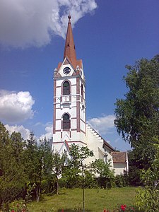
 Reformed church, begun in 1486. | |
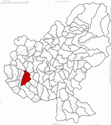
 Location in Mureș County | |
 Iernut Location in Romania | |
| Coordinates: 46°27′13″N 24°14′0″E | |
| Country | Romania |
| County | Mureș |
| Government | |
| • Mayor (2020–2024) | Ioan Nicoară[1] (PNL) |
| Area | 106.36 km2 (41.07 sq mi) |
| Population (2011)[2] | 8,705 |
| • Density | 82/km2 (210/sq mi) |
| Time zone | EET/EEST (UTC+2/+3) |
| Vehicle reg. | MS |
| Website | www |
The commune is situated on the Transylvanian Plateau. It lies on the banks of the Mureș River; the Lechința River discharges into the Mureș here.
Demographics
| Year | Pop. | ±% |
|---|---|---|
| 1992 | 9,719 | — |
| 2002 | 9,833 | +1.2% |
| 2011 | 8,373 | −14.8% |
| Source: Census data | ||
The 2011 census revealed the following demographic data:[3]
- Romanians (76.55%)
- Hungarians (13.36%)
- Roma (9.84%)
- others (0.18%)
Main sights
- The Reformed church (built between 1486 and 1593);
- Kornis-Rakóczi-Bethlen Castle (built in 1545);
- The two lakes near the city;
- Mureș River;
- Lupoaica;
- Old Buildings.
References
Wikimedia Commons has media related to Iernut.
- "Results of the 2020 local elections". Central Electoral Bureau. Retrieved 11 June 2021.
- "Populaţia stabilă pe judeţe, municipii, oraşe şi localităti componenete la RPL_2011" (XLS). National Institute of Statistics.
- 2002 Census Data
На других языках
[de] Iernut
Iernut (deutsch Radnuten, ungarisch Radnót) ist eine Kleinstadt im Kreis Mureș in Rumänien.- [en] Iernut
[ru] Ернут
Ернут (рум. Iernut, венг. Radnót, нем. Radnuten) — город в Румынии, входит в состав жудеца Муреш.Текст в блоке "Читать" взят с сайта "Википедия" и доступен по лицензии Creative Commons Attribution-ShareAlike; в отдельных случаях могут действовать дополнительные условия.
Другой контент может иметь иную лицензию. Перед использованием материалов сайта WikiSort.org внимательно изучите правила лицензирования конкретных элементов наполнения сайта.
Другой контент может иметь иную лицензию. Перед использованием материалов сайта WikiSort.org внимательно изучите правила лицензирования конкретных элементов наполнения сайта.
2019-2025
WikiSort.org - проект по пересортировке и дополнению контента Википедии
WikiSort.org - проект по пересортировке и дополнению контента Википедии

