world.wikisort.org - Romania
Dâmbovicioara is a commune in Argeș County, Muntenia, Romania. It is composed of three villages: Ciocanu, Dâmbovicioara and Podu Dâmboviței.
Dâmbovicioara | |
|---|---|
Commune | |
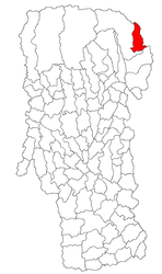 Location in Argeș County | |
 Dâmbovicioara Location in Romania | |
| Coordinates: 45°26′N 25°13′E | |
| Country | Romania |
| County | Argeș |
| Area | 63.07 km2 (24.35 sq mi) |
| Population (2011)[1] | 943 |
| • Density | 15/km2 (39/sq mi) |
| Time zone | EET/EEST (UTC+2/+3) |
| Vehicle reg. | AG |
The Dâmbovița River has its source in Podu Dâmboviței, on the Curmătura Oticului, a mountain pass that separates the Iezer Mountains from the Făgăraș Mountains.
Villages
Dâmbovicioara
Dâmbovicioara is the village of residence of the commune of the same name in Argeș County, Muntenia, Romania.[2]
Podu Dâmboviței
Podu Dâmboviței is a village with 745 inhabitants, located on DN73 29 km from Câmpulung. The was for the first time mentioned in 16th-17th centuries.[2]
Ciocanu

Geography
The village’s name, meaning “the hammer”, derives from its shape, with the tip pointing towards Dâmbovicioara village. It is surrounded by the Bucegi, Piatra Craiului and Leaota Mountains.[3]
The village is located at the northern edge of the commune, at the foot of the Piatra Craiului Mountains, on the Rucăr-Bran Pass. To the north, the next village is Șirnea, part of Transylvania.[2]
History
Ciocanu was founded and named around 1850 by Iosif Căciulă, Teche Poponeci and Bucur Stinghe, three deserters from the Imperial Austrian Army who purchased land from the elders of Rucăr. Until the union of Transylvania with Romania, it was a border village in the Romanian Old Kingdom, with Austria-Hungary on the other side. The crossing was known as the “cuckoo border”, because like the bird that flew freely between, it was quite permeable, with the inhabitants prospering from the traffic.[3]
The border is a natural one, with its location along a mountain crest. In ancient times, it divided Thracian tribes of shepherds and farmers. A document of 1377 mentions this saddle as the first customs point over the mountains, under the name Ruffa Abor. In the late 16th century, Doamna Florica, the daughter of Michael the Brave, took possession of the village, in turn granting property to the Rucăr elders.[3]
In 1916, during the early stages of Romania’s participation in World War I, the area was the scene of heavy fighting. Reportedly, prior to the war, a German spy posing as a hunter had photographed the Romanian military’s local strategic defenses.[3]
Gallery
![Oratea Fortress [ro] in Podu Dâmboviței, where Vlad the Impaler was once imprisoned](//upload.wikimedia.org/wikipedia/commons/thumb/7/77/Cetatea_Oratea-zid_si_DN73.jpg/90px-Cetatea_Oratea-zid_si_DN73.jpg) Oratea Fortress in Podu Dâmboviței, where Vlad the Impaler was once imprisoned
Oratea Fortress in Podu Dâmboviței, where Vlad the Impaler was once imprisoned Roman road in Podu Dâmboviței
 Gheorghe Tattarescu painting of Dâmbovicioara Cave
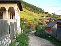 View of Dâmbovicioara
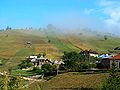 View of Dâmbovicioara
![Oratea Fortress [ro] in Podu Dâmboviței, where Vlad the Impaler was once imprisoned](http://upload.wikimedia.org/wikipedia/commons/7/77/Cetatea_Oratea-zid_si_DN73.jpg)


References
- "Populaţia stabilă pe judeţe, municipii, oraşe şi localităti componenete la RPL_2011" (XLS). National Institute of Statistics.
- "Istoricul localitatii – Primăria Dâmbovicioara" (in Romanian). Archived from the original on 2019-04-25. Retrieved 2021-08-15.
- "Ciocanu – tristețea unui sat de două țări". Opinia studențească (in Romanian). 2020-01-20. Retrieved 2021-08-15.
External links
Argeș County, Romania | ||
|---|---|---|
| Cities |
|  |
| Towns | ||
| Communes |
| |
This Argeș County location article is a stub. You can help Wikipedia by expanding it. |
Другой контент может иметь иную лицензию. Перед использованием материалов сайта WikiSort.org внимательно изучите правила лицензирования конкретных элементов наполнения сайта.
WikiSort.org - проект по пересортировке и дополнению контента Википедии