world.wikisort.org - Portugal
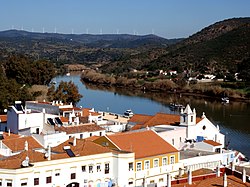
Alcoutim es una villa portuguesa perteneciente al distrito de Faro, región del Algarve, con cerca de 1100 habitantes.
| Alcoutim | ||||
|---|---|---|---|---|
| Entidad subnacional | ||||
 | ||||
 Alcoutim Localización de Alcoutim en Portugal | ||||
| Coordenadas | 37°28′12″N 7°28′23″O | |||
| Idioma oficial | Portugués | |||
| Entidad | Municipio de Portugal | |||
| • País |
| |||
| • Región | Algarve | |||
| • Distrito | Faro | |||
| Freguesias | 4 | |||
| Eventos históricos | ||||
| • Fundación | 1304 | |||
| Superficie | ||||
| • Total | 576.57 km² | |||
| Altitud | ||||
| • Media | 193 m s. n. m. | |||
| Población (2021) | ||||
| • Total | 2521 hab. | |||
| • Densidad | 7 hab/km² | |||
| Gentilicio | alcoutenejo | |||
| Huso horario | UTC±00:00 | |||
| Código postal | 8970[1] | |||
| Sitio web oficial | ||||


Geografía
Es sede de un municipio con 576,57 km² de área y 3770 habitantes (2001), subdividido en 4 freguesias.
Límites
El municipio limita al norte con el municipio de Mértola, al este con Sanlúcar de Guadiana en Andalucía, al sureste con Castro Marim, al suroeste con Tavira y al oeste con Loulé y Almodôvar.
Historia
Mientras Juan I de Portugal buscaba gobernadores para Ceuta, el joven Pedro de Menezes estaba cerca, jugando distraídamente choca (una especie de hockey medieval) con un palo de zambujeiro o Aleo (olivo silvestre). Escuchando a todos los altos nobles inventando excusas para evitar el trabajo, el joven Pedro de Menezes dio un paso adelante y se acercó al rey con su palo de juego (aleo) en la mano y le dijo que, con solo ese palo, podía defender a Ceuta de todo el poder de Marruecos. Como resultado de En esta historia, a todos los futuros gobernadores portugueses de Ceuta se les presentaría un personal de zambujeiro como símbolo de su cargo en su investidura.) El aleo que fue utilizado por Pedro se conserva en la Santuario de Santa María de África en Ceuta, la estatua de Maria sostiene el aleo.[2][3]
Se puede ver 'Aleu' o 'aleo' en el escudo de armas de Alcoutim y Vila Real, donde los descendientes de Pedro se hicieron Conde de Alcoutim o Conde de Vila Real, respectivamente.
Demografía
| Gráfica de evolución demográfica de Alcoutim entre 1864 y 2021 |
 |
|
Datos según el nomenclátor publicado por el INE portugués. |
Freguesias
Las freguesias de Alcoutim son las siguientes:[4]
- Alcoutim e Pereiro
- Giões
- Martim Longo
- Vaqueiros
Referencias
- Worldpostalcodes.org,código postal n.º 8970.
- "Eu só com este páu, sou capaz de defender Ceuta, de todo o poder dos mouros" Portugal antigo e moderno, 1878, p.495. Z.N. Gonçalves Brandão, 1883, Monumentos e lendas de Santarem , p.514
- Horizontes da Memória - A Tomada de Ceuta - 2002
- «Lei n.º 11-A/2013 de 28 de janeiro. Reorganização administrativa do território das freguesias». Diário da República (en portugués). 28 de enero de 2013. Consultado el 15 de febrero de 2022.
Enlaces externos
 Wikimedia Commons alberga una categoría multimedia sobre Alcoutim.
- Ayuntamiento de Alcoutim (en portugués)
| Control de autoridades |
|
|---|
На других языках
[de] Alcoutim
Alcoutim ist eine Kleinstadt (Vila) und ein Kreis (Concelho) mit 2917 Einwohnern (Stand 30. Juni 2011) in Portugal, im Distrikt Faro. Sie liegt im äußersten Nordosten der Algarve am Grenzfluss Guadiana.[en] Alcoutim
Alcoutim (Portuguese pronunciation: [alkowˈtĩ] (listen)) is a town and a municipality in southeastern Portugal near the Portugal–Spain border.[1] The population in 2011 was 2,917,[2] in an area of 575.36 km².[3] It is the least densely populated municipality in Portugal. The municipality is limited on the north by Mértola Municipality, on the east by Huelva Province in Spain, on the southeast by Castro Marim Municipality, on the southwest by Tavira Municipality and on the west by Loulé Municipality and Almodôvar Municipality. The administrative center is the town of Alcoutim, located at the extreme eastern part of the municipality on the Spanish frontier, just across the Guadiana River from the Spanish town of Sanlúcar de Guadiana in Huelva Province. The Moorish Alcoutim Castle, located in the municipality, dates from the 14th century.[4]- [es] Alcoutim
[it] Alcoutim
Alcoutim (aɫko(ou)'tĩ) è un comune portoghese di 3.770 abitanti situato nel distretto di Faro.[ru] Алкотин
Алкоти́н (порт. Alcoutim; [aɫko'tĩ]) — посёлок городского типа в Португалии, центр одноимённого муниципалитета в округе Фару. Численность населения — 1,1 тыс. жителей (посёлок), 3,3 тыс. жителей (муниципалитет). Посёлок и муниципалитет входит в регион Алгарве и субрегион Алгарве. Часть городской агломерации Большое Алгарве.Другой контент может иметь иную лицензию. Перед использованием материалов сайта WikiSort.org внимательно изучите правила лицензирования конкретных элементов наполнения сайта.
WikiSort.org - проект по пересортировке и дополнению контента Википедии