world.wikisort.org - Portugal
Sé is a parish in the municipality of Angra do Heroísmo on the island of Terceira in the Azores. The population in 2011 was 955,[1] in an area of 1.65 km².[2] It is one of the smallest parishes in Angra do Heroísmo.
Sé | |
|---|---|
Civil parish | |
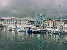
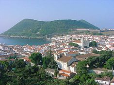
 The iconic imagery of the city of Angra, are all part of the parish of Sé, including the marina, cathedral and gates of the city | |
 Coat of arms | |
 Sé Location in the Azores  Sé Sé (Terceira) | |
| Coordinates: 38°39′18″N 27°13′15″W | |
| Country | |
| Auton. region | Azores |
| Island | Terceira |
| Municipality | Angra do Heroísmo |
| Established | Settlement: fl. 1500 Parish: c. 1534 Civil parish: 25 November 1830 |
| Area | |
| • Total | 1.65 km2 (0.64 sq mi) |
| Elevation | 27 m (89 ft) |
| Population (2011) | |
| • Total | 955 |
| • Density | 580/km2 (1,500/sq mi) |
| Time zone | UTC−01:00 (AZOT) |
| • Summer (DST) | UTC±00:00 (AZOST) |
| Postal code | 9700-171 |
| Area code | (+351) 292 XXX-XXXX |
| Patron | São Salvador |
| Website | http://www.juntafreguesiase.org |
History

Designated the island of Jesus Christ (Ilha de Jesus Cristo), at the time of its discovery and exploration by Portuguese navigators: the settlement of Terceira began around 1450, when it was conceded to the Fleming Jácome de Bruges, by Infante D. Henrique.[3] The first settlers to the island disembarked in the areas of Porto Judeu and Pria, and slowly extended throughout the island.[3]
In the hilltop of Monte Brasil is the Fort of São João Baptista (also known as the Fort of São Filipe), built at the beginning of the era of Castilian occupation of the archipelago.[3] It was constructed with the intention of being a potent fortress, to guard the riches and circulation of European shipping into the Americas.[3] This castle, with its high walls and grande scale, was constructed from the middle of the 16th century and first half of the following century. During the period of the Portuguese Restoration War, which began with the revolution of 1 December 1640, and ended with the peace of 1668, forces loyal to the Spanish resisted the Portuguese.[3] It was only two years later, in 1642, that the Spanish rendered and the city of Angra were, in fact, freed.[3]
The name Sé came from the topological name for the religious administrative territory governed by the diocesan cathedral in Angra: Sé is the location of the only cathedral in the archipelago of the Azores.[3]
Geography

Situated on the island of Terceira, the civil parish of Sé, along with the surrounding parishes constitute the city of Angra do Heroísmo, seat of the municipality.
Economy
Many of the economic activities in the parish are related to commerce and service sectors, since the island is a primary destination for tourism.[3]
Architecture
Civic
- Episcopal Palace of Angra do Heroísmo (Portuguese: Paço episcopal de Angra do Heroísmo), former 16th century manorhouse, used as the residence of the Bishop of Angra over the centuries, eventually converted and reused in the public sector.
Religious
- Sé Cathedral (Portuguese: Sé Catedral de Angra do Heroísmo), built after 1570, over the ruins of the 15th century Church of the Divino Salvador, which were severely damaged.[3] Destroyed by violent earthquakes, in the 18th century the Sé of Angra was reconstructed in accord with the Mannerist principals of the 16th century.[3] Its main facade included two two-story bell-towers, linked by a pediment with central clock and iron cross.[3]
References
- Notes
- Instituto Nacional de Estatística
- Eurostat
- Junta Freguesia, ed. (2012), Resumo Histórico (in Portuguese), Junta Freguesia da Sé, retrieved 12 October 2013
На других языках
[de] Sé (Angra do Heroísmo)
Sé ist eine portugiesische Gemeinde (Freguesia) im Kreis Angra do Heroísmo; sie bildet einen Teil der Stadt Angra mit der namensgebenden Kathedrale. In ihr leben 955 Einwohner (Stand 30. Juni 2011).[1] Auf dem Gebiet der Gemeinde befindet sich mit der Ruine Castelo dos Moinhos eine der ältesten portugiesischen Verteidigungsanlagen der Insel.- [en] Sé (Angra do Heroísmo)
[es] Sé (Angra do Heroísmo)
Sé es una freguesia portuguesa perteneciente al municipio de Angra do Heroísmo, situado en la Isla Terceira, Región Autónoma de Azores. Posee un área de 1,84 km² y una población total de 1 200 habitantes (2001). La densidad poblacional asciende a 652,2 hab/km².[ru] Се (Ангра-ду-Эроишму)
Се (порт. Sé) — район (фрегезия) в Португалии, входит в округ Азорские острова. Расположен на острове Терсейра. Является составной частью муниципалитета Ангра-ду-Эроижму. Население составляет 1200 человек на 2001 год. Занимает площадь 1,84 км².Другой контент может иметь иную лицензию. Перед использованием материалов сайта WikiSort.org внимательно изучите правила лицензирования конкретных элементов наполнения сайта.
WikiSort.org - проект по пересортировке и дополнению контента Википедии
