world.wikisort.org - Portugal
São Domingos de Rana (Portuguese pronunciation: [sɐ̃w̃ duˈmĩɡuʃ dɨ ˈʁɐnɐ]) is a civil parish (Portuguese: freguesia) of the Portuguese municipality of Cascais, part of the Greater Lisbon subregion. The population in 2011 was 57,502,[1] in an area of 20.36 km².[2] The parish includes the localities Abóboda, Cabeço de Mouro, Caparide, Matarraque, Outeiro de Polima, Polima, Rana, Talaíde, Tires, Trajouce and Zambujal.
São Domingos de Rana | |
|---|---|
Civil parish | |
 A view of the residential area of Penedo | |
 Coat of arms | |
 São Domingos de Rana Location in Portugal | |
| Coordinates: 38.702°N 9.340°W | |
| Country | |
| Region | Lisbon |
| Metropolitan area | Lisbon |
| District | Lisbon |
| Municipality | Cascais |
| Area | |
| • Total | 20.36 km2 (7.86 sq mi) |
| Population (2011) | |
| • Total | 57,502 |
| • Density | 2,800/km2 (7,300/sq mi) |
| Time zone | UTC±00:00 (WET) |
| • Summer (DST) | UTC+01:00 (WEST) |
| Postal code | 2785 |
| Area code | 214 |
| Patron | Saint Dominic |
| Website | http://www.jf-sdrana.pt |
History


The settlement of São Domingos de Rana, is associated with the fertility of the soils and the abundance of spring-waters: the number of archaeological vestiges in the parish implies its place in the settlement of the municipality.[3] In many localities of the parish, human occupation has been almost permanent since the Paleolithic.[3] The archaeological graves in the region attest to agricultural and hunting cultures.[3] This parishes origins date to the settlement of the territory during the Paleolithic to Medieval.[3] The first historical references originated in the Middle Age, one attesting to the existence of locality of Trajouce and the other that mentioned (in 1385) the casal in Freira.[3]
The first census referred, in 1527, referred to all the current localities in the parish.[3] At that time, there was already a parish of São Domingos de Rana, that extended to Albarraque, expanding in 1758 to São Pedro do Estoril. Until 1838, the area was part of the municipality of Oeiras, before integrated into Cascais.[3]
For four decades the territory was exclusively agricultural, cultivating wheat, corn and vegetables, in addition to vineyards. Also, the region was known for the extraction of stone used in the construction.[3] In 1983, professor José d’Encarnação described São Domingos de Rana as an area known of cereal harvests, but was slowly threatened by the growth of the city, and the industrial production of Abóboda.[3] With its accelerated growth, and lack of planning, resulted in the growth of illegal barrios.[3] On 3 March 1976, the Ministérios da Habitação, Urbanismo e Construção and Ministério dos Assuntos Sociais created an interministerial group (the Comissão para o Alojamento de Refugiados - CAR) in order to coordinate and develop solutions for the housing ex-colonial Africans and refugees, then living in emergency housing in Lisbon or along the Algarve.[4] The development of the CAR neighbourhood of Faceiras, in three phases, began on 18 August 1977 with the construction of 81 homes.[4] The following year (resolution 99/78) this program was integrated with other projects by the commission and the Fundo de Fomento da Habitação (FFH) (Housing Development Fund) to sustain the program (17 June 1978).[4][5]
Geography
With 20 square kilometres (7.7 sq mi), São Domingos de Rana is one of the four parishes in the municipality of Cascais. In 1970 its resident population included 18,140 inhabitants, expanding to 29,342 (in 1981), 35,938 (in 1991) and 43,991 (in 2001): the 2011, included a population of 57,502 inhabitants.[3]
The protected Costa do Sol-Guincho area is situated along the southern margin at the mouth of the Tagus River, east of Lisbon, with the Serra de Sintra to the northwest and Linha de Sintra to the north: it includes the municipalities of Cascais and Oeiras.[6] It partially includes a portion of the Sintra-Cascais Nature Park (Regulatory Decree 8/94, 11 March 1994), and was also included in the Natura 2000 designation for the site of Sintra-Cascais (Council of Ministers Resolution 142/97, 28 August 1997).[6]
Architecture
Civic
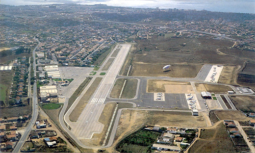
- Cascais Municipal Aerodrome (Portuguese: Aeródromo de Tires), inaugurated on 11 October 1964, by Portuguese President Américo Tomás, the airport developed under the initiative of the Secretário de Estado da Aeronáutica (Secretary of State for Aeronautics) and Direcção-Geral da Aeronáutica Civil (General-Directorate for Civil Aeronatuics), in addition to the Count of Monte Real; planned for the zone of Areia-Guincho, it was installed in Tires, by the Direcção-Geral and military aeronautics which continued into 1973[7]
- Casal Saloio de Outeiro de Polima
- Estate of Rana (Portuguese: Quinta da Rana)[8]
- Estate of Gafanhotos (Portuguese: Quinta dos Gafanhotos)
- Estate of Livramento (Portuguese: Quinta no Livramento)
- Gardens of Quinta dos Pesos (Portuguese: Jardim da Quinta dos Pesos)
- Roman villa of Freira (Portuguese: Villa romana de Freiria), Vergílio Correia was the first to refer to the Roman remains in this zone, after discovering a stone Roman burial mound. The archaeologist discovered a number of fragments of ceramics that date the location to the pre-historic period and the village to about the 4th or 2nd century, which includes the mill and quarters;[9]
- Roman villa of Miroiças (Portuguese: Villa romana de Miroiças), it is the largest Roman villa in the municipality, with a great abundance of materials and superficial content, dating from the Paleolithic and Middle Ages, noting the longest period of human occupation;[10]
- Roman villa of Outeiro de Polima (Portuguese: Villa Romana de Outeiro de Polima), dating to the Roman epoch, when it was constructed, it was discovered by Virgílio Correia in 1913. New excavations were carried-out in 1973, under the archeologist Guilherme Cardoso, whom discovered a large quantity of materials;[11]
Religious

- Church of São Domingos de Gusmão (Portuguese: Igreja Paroquial de São Domingos de Rana/Igreja de São Domingos de Gusmão), its construction dates to 1710, but its conclusion was limited due to the events of the 1755 Lisbon earthquake: it was concluded in 1838 (a date inscribed on the belltower). Between 1911 and 1918, the temple was closed and much of its content began to ruin. By August 2001, a new carillon, with 23 bells, 19 constructed in Braga, 3 pre-existing and one from a factory in Belgium, was inaugurated for the church, electrified and computerized, but manually operatable;[12]
- Chapel of Conceição (Portuguese: Capela da Conceição)[13]
Sister city
 Pánd – Hungary – 2018 since
Education
In the locality of Outeiro de Polima is the Saint Dominic's International School.[14]
References
Notes
- Instituto Nacional de Estatística
- Áreas das freguesias, concelhos, distritos e país
- Caracterização (in Portuguese), São Domingos da Rana (Cascais), Portugal: Junta Freguesia de São Domingos de Rana, 2015
- Ferreira, Teresa; Costa, Anouk (2014), SIPA (ed.), Bairro CAR de Faceiras/Bairro das Faceiras (IPA.00029298/PT031105060281) (in Portuguese), Lisbon, Portugal: SIPA – Sistema de Informação para o Património Arquitectónico, retrieved 18 September 2018
- On 29 May 1982, by decree 214/82 extinguished the FFH; the process continued until 1987, when the management of the fund was placed under the Comissão Liquidatária do Fundo de Fomento da Habitação (Liquidation Committee of the Housing Development Fund).
- Marques, Luís (2010), SIPA (ed.), Paisagem da Costa do Sol - Guincho (IPA.00030538/PT031105060405) (in Portuguese), Lisbon, Portugal: SIPA – Sistema de Informação para o Património Arquitectónico, retrieved 19 September 2018
- Figueiredo, Paula (2010), SIPA (ed.), Aeródromo de Tires (PT031105060408) (in Portuguese), Lisbon, Portugal: SIPA – Sistema de Informação para o Património Arquitectónico, retrieved 16 February 2012
- Rodrigues, Helena (2002), SIPA (ed.), Quinta de Rana (PT031105060068) (in Portuguese), Lisbon, Portugal: SIPA – Sistema de Informação para o Património Arquitectónico, retrieved 16 February 2012
- Noé, Paula (1994), SIPA (ed.), Villa romana de Freiria (PT031105060021) (in Portuguese), Lisbon, Portugal: SIPA – Sistema de Informação para o Património Arquitectónico, retrieved 16 February 2012
- Noé, Paula (1991), SIPA (ed.), Villa romana de Miroiço (PT031105060023) (in Portuguese), Lisbon, Portugal: SIPA – Sistema de Informação para o Património Arquitectónico, retrieved 16 February 2012
- Rodrigues, Helena (2002), SIPA (ed.), Villa Romana de Outeiro de Polima (PT031105060073) (in Portuguese), Lisbon, Portugal: SIPA – Sistema de Informação para o Património Arquitectónico, retrieved 16 February 2012
- Rodrigues, Helena (2001), SIPA (ed.), Igreja Paroquial de São Domingos de Rana/Igreja de São Domingos de Gusmão (PT031105060091) (in Portuguese), Lisbon, Portugal: SIPA – Sistema de Informação para o Património Arquitectónico, retrieved 16 February 2012
- Costa, Patrícia (2002), SIPA (ed.), Capela da Conceição (PT031105060097) (in Portuguese), Lisbon, Portugal: SIPA – Sistema de Informação para o Património Arquitectónico, retrieved 16 February 2012
- Contact, São Domingos de Rana (Cascais), Porutgal: St. Dominic's International School, 2015, retrieved 8 December 2016
Sources
- As ruas de São Domingos de Rana (in Portuguese) (2nd ed.), DSA Editores, 1999, ISBN 972-9893918
- História das Freguesias e Concelhos de Portugal (in Portuguese), vol. 4, Quidnovi - QN Edição de Conteudos, S.A., 2004, ISBN 989-554-152-X
- Grande Enciclopédia Portuguesa e Brasileira (in Portuguese), vol. 27 (1st ed.), Lisbon, Portugal: Editorial Enciclopédia & Resomnia - Editora de Livros e Publicações, p. 456
На других языках
[de] São Domingos de Rana
São Domingos de Rana (sɐ̃ũ duˈmĩguʃ dɨ ˈʁɐnɐ) ist eine Gemeinde (Freguesia) im Kreis (Concelho) von Cascais in Portugal. In São Domingos de Rana leben 57.502 Menschen (Stand 30. Juni 2011) auf einer Fläche von 20,4 km².- [en] São Domingos de Rana
[es] São Domingos de Rana
São Domingos de Rana es una freguesia portuguesa del municipio de Cascaes. Según el censo de 2021, tiene una población de 59 248 habitantes.[2][ru] Сан-Домингуш-де-Рана
Сан-Домингуш-де-Рана (порт. São Domingos de Rana) — район (фрегезия) в Португалии, входит в округ Лиссабон. Является составной частью муниципалитета Кашкайш. Находится в составе крупной городской агломерации Большой Лиссабон. По старому административному делению входил в провинцию Эштремадура. Входит в экономико-статистический субрегион Большой Лиссабон, который входит в Лиссабонский регион. Население составляет 57 502 человека на 2011 год. Занимает площадь 20,51 км².Другой контент может иметь иную лицензию. Перед использованием материалов сайта WikiSort.org внимательно изучите правила лицензирования конкретных элементов наполнения сайта.
WikiSort.org - проект по пересортировке и дополнению контента Википедии