world.wikisort.org - Portugal
Soure (Portuguese pronunciation: [ˈso(w)ɾ(ɨ)] (![]() listen)) is a town and municipality of the Coimbra District, in Portugal. The population in 2011 was 19,245,[1] in an area of 265.06 km².[2] It includes a castle listed as a national monument.
listen)) is a town and municipality of the Coimbra District, in Portugal. The population in 2011 was 19,245,[1] in an area of 265.06 km².[2] It includes a castle listed as a national monument.
Soure | |
|---|---|
Municipality | |
 Flag  Coat of arms | |
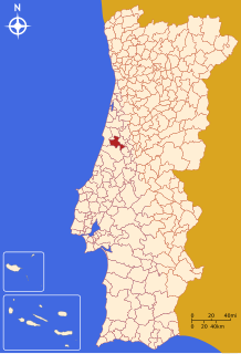 | |
| Coordinates: 40°03′N 8°38′W | |
| Country | |
| Region | Centro |
| Intermunic. comm. | Região de Coimbra |
| District | Coimbra |
| Parishes | 10 |
| Area | |
| • Total | 265.06 km2 (102.34 sq mi) |
| Highest elevation | 531 m (1,742 ft) |
| Lowest elevation | 6 m (20 ft) |
| Population (2011) | |
| • Total | 19,245 |
| • Density | 73/km2 (190/sq mi) |
| Time zone | UTC±00:00 (WET) |
| • Summer (DST) | UTC+01:00 (WEST) |
Parishes
Administratively, the municipality is divided into 10 civil parishes (freguesias):[3]
- Alfarelos
- Degracias e Pombalinho
- Figueiró do Campo
- Gesteira e Brunhós
- Granja do Ulmeiro
- Samuel
- Soure
- Tapeus
- Vila Nova de Anços
- Vinha da Rainha
Climate
| Climate data for Soure | |||||||||||||
|---|---|---|---|---|---|---|---|---|---|---|---|---|---|
| Month | Jan | Feb | Mar | Apr | May | Jun | Jul | Aug | Sep | Oct | Nov | Dec | Year |
| Average precipitation mm (inches) | 125 (4.9) |
107 (4.2) |
88 (3.5) |
70 (2.8) |
65 (2.6) |
29 (1.1) |
8 (0.3) |
11 (0.4) |
39 (1.5) |
87 (3.4) |
112 (4.4) |
120 (4.7) |
861 (33.8) |
| Source: Portuguese Environment Agency[4] | |||||||||||||
References
- Instituto Nacional de Estatística
- Áreas das freguesias, concelhos, distritos e país
- Diário da República. "Law nr. 11-A/2013, pages 552 116-117" (pdf) (in Portuguese). Retrieved 31 July 2014.
- "Monthly Precipitation Soure". APA. Retrieved 4 June 2021.
External links
Authority control | |
|---|---|
| General |
|
| National libraries | |
| Other |
|
This Coimbra location article is a stub. You can help Wikipedia by expanding it. |
На других языках
- [en] Soure, Portugal
[es] Soure (Portugal)
Soure es una villa portuguesa del distrito de Coímbra, região Centro y comunidad intermunicipal de Coímbra, con cerca de 8 500 habitantes.[ru] Сори (Коимбра)
Сори (порт. Soure; ['so(ou)ɾ(ɨ)]) — посёлок городского типа в Португалии, центр одноимённого муниципалитета в составе округа Коимбра. Находится в составе крупной городской агломерации Большая Коимбра. Численность населения — 8,5 тыс. жителей (посёлок),20,9 тыс. жителей (муниципалитет). Посёлок и муниципалитет входит в экономико-статистический регион Центральный регион и субрегион Байшу-Мондегу. По старому административному делению входил в провинцию Бейра-Литорал.Текст в блоке "Читать" взят с сайта "Википедия" и доступен по лицензии Creative Commons Attribution-ShareAlike; в отдельных случаях могут действовать дополнительные условия.
Другой контент может иметь иную лицензию. Перед использованием материалов сайта WikiSort.org внимательно изучите правила лицензирования конкретных элементов наполнения сайта.
Другой контент может иметь иную лицензию. Перед использованием материалов сайта WikiSort.org внимательно изучите правила лицензирования конкретных элементов наполнения сайта.
2019-2025
WikiSort.org - проект по пересортировке и дополнению контента Википедии
WikiSort.org - проект по пересортировке и дополнению контента Википедии